


California and National Drought Summary for March 23, 2021
Summary
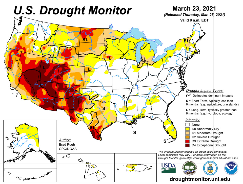
March 25, 2021 - A couple of low pressure systems resulted in widespread precipitation (0.5 to 3 inches, locally more) across the central and southern Plains, Ohio and Tennessee Valleys, Southeast, and Mid-Atlantic from March 16 to 22. However, mostly dry weather persisted across southern Texas, the Florida Peninsula, northern New England, the Great Lakes, and northern Plains. Periods of rain and high-elevation snow occurred across the Pacific Northwest, northern California, and the central Rockies, but the Southwest remained mostly dry. As of March 23, 7-day maximum temperatures averaged above normal across the northern Plains and Upper Mississippi Valley.
Northeast
Following below normal precipitation during the first half of March, widespread precipitation (0.5 to 1.5 inches) overspread the northern Mid-Atlantic and southern New England. However, much of Maine, northern New Hampshire and Vermont, Upstate New York, and parts of Massachusetts remained mostly dry. Therefore, a slight increase in D0 (abnormal dryness) and D1 (moderate drought) was made. Although 28-day streamflows generally are running average, soil moisture and SPI values at various time scales support the ongoing D0 and D1. Also, areas east of Lake Erie (northeast Pennsylvania and western New York) had an expansion of D0 this week.
Southeast
On March 17 and 18, a severe weather outbreak occurred with numerous tornado reports across Alabama, Georgia, Florida, North Carolina, and southeast Virginia. In addition to the severe weather, widespread rainfall (0.5 to 2 inches, locally more) soaked much of the Southeast which prompted a 1-category improvement to ongoing D0 (abnormal dryness) and D1 (moderate drought). 28-day streamflows and 60 day SPI values continue to support lingering areas of D0-D1 across Alabama. Parts of northern and central Georgia received less rainfall this past week which prompted an increase in abnormal dryness (D0) based largely on 60-day SPI. The Florida Peninsula remained mostly dry this past week and the D0 (abnormal dryness) was expanded. D1 (short-term moderate drought) was added to mainland areas of Monroe County in south Florida where less than 2 inches of rainfall has occurred during the past 90 days and fire danger is very high.
South
The severe weather outbreak that affected the Southeast Region began across the Lower Mississippi Valley on March 17 and local rainfall amounts exceeded 2 inches across parts of Arkansas, Louisiana, and Mississippi where 1-category improvements were made. More widespread rainfall amounts of more than 1.5 inches increased soil moisture throughout nearly all of Tennessee. Based on this past week’s rainfall of 1 to 3 inches and improving soil moisture conditions, improvements were made to much of Oklahoma and parts of northern to central Texas. Small 2-category improvements were justified for the northeast Texas Panhandle and northwest Oklahoma where the heaviest rainfall occurred. Periods of above normal temperatures, enhanced surface winds, and below normal precipitation this month supported a continued worsening of drought conditions throughout southern Texas. Soil moisture declines rapidly from central to west Texas where indicators support D3 (extreme) to D4 (exceptional) drought categories.
Midwest
Widespread precipitation (0.5 to 2 inches) fell from Missouri east to Kentucky, Illinois, Indiana, and Ohio on March 17 and 18. This recent precipitation maintained saturated soils, high streamflows, and minor to moderate river flooding across the Middle Mississippi Valley and Lower Ohio Valley. In areas that were drier preceding this precipitation, extending from northeast Missouri east to Ohio, a large decrease in D0 (abnormal dryness) and D1 (moderate drought) coverage was warranted. However, this recent rainfall had to be balanced with longer term SPIs. There was a sharp northward cutoff to this precipitation and D0-D1 coverage was increased across lower Michigan, extreme northern Indiana, and southern Wisconsin based on soil moisture and SPI values at various time scales.
High Plains
Frequent precipitation during the past two weeks continues to result in additional improvements to parts of the central Plains and central Rockies. 7-day total amounts (March 16-22) ranged from 1 to 3 inches, locally more, across a broad region including south-central Nebraska and much of Kansas. As of March 22, Grand Island Nebraska has received 6.95” so far this month which makes it the wettest March on record. The drought amelioration extends west to the central Rockies where numerous improvements were made including a two-category change from D3 to D1 in southwest El Paso County and southeast Teller County as SPIs are now D1 at all timescales. The removal of D3 in southeast Colorado and southwest Kansas was based on: SPIs are either neutral or positive dating back to 6 months and improving soil moisture conditions. In contrast to the major improvements across the central Rockies and central Plains during the past two weeks, persistent dryness continues to support additional expansion of D2 (severe) and D3 (extreme) drought across parts of North Dakota.
West
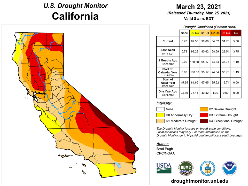
A slight expansion of severe drought (D2) was made to northeast Montana, based on 90-day SPI and soil moisture below the 10th percentile. These low soil moisture conditions are related to the lack of snowfall this winter. In contrast to the northern high Plains, snow water content is running close to average for late March and led to the elimination of abnormal dryness (D0) across south-central Montana. Since parts of western Arizona and southeast California have received little to no precipitation during the past two month, D3 (extreme) and D4 (exceptional) drought were slightly increased. This expansion of D3-D4 was supported by 9-month SPI values which covers the failed 2020 monsoon and this past winter. An expansion of D2 (severe) and extreme (D3) drought across parts of southern California was based on large water year to date precipitation deficits and 6-month SPI values. No other changes were made at this time to the remainder of California as 6 to 12 month SPIs generally support the current depiction and snow water content is running near two-thirds of average for the Sierra Nevada Mountains. During subsequent weeks, the drought depiction will be reassessed across California. Although much of the precipitation this past week fell along the coast or over the Cascades, a reassessment of longer term SPIs dating back 6 to 12 months supported removal of the D2 (severe) drought in southwest Oregon. Due in part to recent high-elevation snow and rainfall during the past two weeks, a slight decrease in D3 (extreme) and D4 (exceptional) drought was made to northern and northeast New Mexico. However, widespread D4 persists across southeast New Mexico where dust storms have been quite frequent this month and soil moisture remains in the lowest one percentile.
Alaska, Hawaii, and Puerto Rico
Abnormal dryness continues for northern and eastern Mainland Alaska with no changes this week. As of mid-March the water year precipitation remains below 70 percent for northeast parts of Alaska.
Numerous preliminary reports of 6-day totals, ending on March 13, exceeded 10 inches across parts of these islands and maximum amounts of more than 20 inches were reported. Based on this heavy rainfall during mid-March, a broad 1-category improvement was made to Hawaii which results in limiting long-term drought (D1) to only Maui.
After above normal precipitation resulted in a decrease of abnormal dryness (D0) and short-term moderate drought (D1) during the previous week, drier weather returned and no changes were made to Puerto Rico.
Pacific Islands
The weather features across the U.S.-Affiliated Pacific Islands (USAPI) during this USDM week (03/17/21-03/23/21) included near-equatorial troughs which persisted across Palau and Yap State, accompanied early in the week by a weak circulation; an Inter-Tropical Convergence Zone (ITCZ) across the central to eastern Federated States of Micronesia (FSM) and southern Marshall Islands (RMI), fed by wind-speed convergence and interlaced with surface troughs; and a dry trade-wind regime across the Marianas with minor interference from weak shear lines or surface troughs. South of the equator, American Samoa encountered a surface trough, mid- to upper-level low pressure, and nearby surface low early in the week, with a high pressure ridge taking control later in the week.
Satellite-based estimates of 7-day precipitation (QPE) showed a band of precipitation stretching east-west across Micronesia (the ITCZ), with areas of 2+ inches over Palau and Yap State, and areas of 4+ inches further east. The areas with the heaviest precipitation were between the equator and 5 degrees North latitude over central FSM, and southern portions of the RMI. Patchy areas of up to 1 inch of rain were detected by this tool near and over parts of the Marianas, but mostly no rain was indicated for the northern parts of the USAPI. A large area of 4+ inches of rain, with embedded 10+ inches, was indicated south of the Samoan Islands, with 2+ inches sweeping across American Samoa.
Both Palau and American Samoa were wet (more than the 2-inch and 1-inch, respectively, weekly minimum precipitation needed to meet most water needs) this week. Weekly rainfall totals in Palau included 2.48 inches at the Palau IAP and 3.40 inches at Koror COOP/ROR, and, in American Samoa, 1.94 inches at Pago Pago, 2.11 inches at the automated station at Toa Ridge, and 3.12 inches at the automated station at Siufaga Ridge. With monthly totals above the corresponding monthly minimums through March 23, D-Nothing continued at Palau and Tutuila.
With the exception of the NPS automated station at Saipan (1.13 inches), this week was dry (below the 1-inch weekly minimum needed to meet most water needs) in the Marianas. Based on data received for the week, a third of an inch or less was recorded at Guam (0.39 inch), Rota (0.11), Tinian (0.17), Saipan ASOS (0.22), and Saipan IAP (0.03). Guam (2.51 inches) and Rota (2.76 inches) had more than 2 inches for the month so far, but that was still below the corresponding monthly minimum. The Saipan stations had about an inch or less (1.30 at NPS, 0.60 at ASOS, and 0.21 at IAP). Abnormal dryness (D0-S) continued at Guam and Rota and moderate drought (D1-S) continued at Saipan.
The ITCZ gave eastern and southern portions of the FSM a wet week, with rainfall totals in the east ranging from 2.11 inches at Pohnpei to 3.27 inches at Kosrae, and in the south ranging from 1.98 inches at Kapingamarangi to 3.25 inches at Nukuoro, based on data through March 22 or 23. It was a dry week (less than the 2-inch weekly minimum) at stations in the western FSM and at Pingelap (1.34 inches) in the east. Weekly totals at the western stations ranged from 1.17 inches at Fananu to 1.45 inches at Yap. Ulithi reported 0.26 inch but with 3 days missing. Monthly totals were below the monthly minimum (for this point in March) at Nukuoro (5.31 inches) and Lukunor (5.70), but wet at the other FSM stations. D0-S continued this week at Fananu due to the dry week, but with 7.67 inches of rain for the month so far, improvement may be made next week if sufficient rain falls. D3-SL continued at Kapingamarangi, but with 6.07 inches so far this month, improvement may be made next week if sufficient rain falls to improve conditions on the ground. D-Nothing continued at the rest of the FSM stations.
In the Marshall Islands, no data was received from Utirik this week so an analysis could not be made for this station. The ITCZ soaked parts of the southern RMI while northern portions were dry. Mili recorded 8.67 inches of rain this week, Ailinglaplap 4.36 inches, Jaluit 3.01 inches, and Majuro 2.33 inches. On the dry side, Kwajalein reported 0.91 inch and Wotje 0.45 inch. With the month-to-date total (9.32 inches) now well above the 8-inch monthly minimum, Jaluit was improved from D0-S to D-Nothing. D1-S continued at Kwajalein, where the monthly total rainfall so far was 5.33 inches, and D3-S continued at Wotje where only 0.45 inch of rain has been reported for the month. The reservoir level at Majuro on March 22 was 25.2 million gallons, or 70% of maximum which was below the 80% threshold for concern, but sufficient rain has been falling to keep the status D-Nothing. D-Nothing continued at the rest of the RMI stations.
Virgin Islands
The weather conditions across the U.S. Virgin Islands (USVI) during this USDM week (03/17/21-03/23/21) were dominated by upper-level ridging and surface high pressure. Patchy shallow moisture fed spotty light showers triggered by weak trade-wind perturbations, but dry stable air was the rule.
Radar-based estimates of rainfall (QPE) for the 7 days ending at 12z on Tuesday showed a fourth of an inch or less of precipitation across western portions of St. Croix and St. Thomas, with less than a tenth of an inch to no precipitation further east. USGS data showed groundwater levels continuing to decline across all three islands. Reports indicated browning of vegetation across St. John.
Weekly rainfall totals on St. Croix ranged from no measurable rain at East Hill to 0.30 inch at the CoCoRaHS station at Frederiksted 0.5 N, on St. Thomas ranged from 0.06 inch at Anna's Retreat 2.5 ESE to 0.22 inch at Charlotte Amalie West 4.2 WNW, and on St. John from 0.12 inch at Cruz Bay 1.6 E to 0.23 inch at Windswept Beach and 0.65 inch at Cruz Bay 0.8 NE. Weekly normal rainfall is about a third of an inch at the airport stations. Monthly rainfall totals (through March 23) ranged from 0.23 inch (Rohlsen AP) to 1.53 inches (Frederiksted 0.5 N) on St. Croix, from 0.07 inch (Anna's Retreat 2.5 ESE) to 0.81 inch (Charlotte Amalie 1.4 NE) on St. Thomas, and from 0.44 inch (Cruz Bay 1.6 E) to 0.79 inch (Cruz Bay 0.8 NE) on St. John. Rohlsen AP had the fifth driest March so far (out of 62 years) while King AP ranked 13th driest out of 58 years and East Hill 22nd driest out of 48 years. Both King AP and East Hill had the seventh driest year-to-date. With the continued dryness, D1-SL continued on St. Croix and D2-S continued on St. Thomas and St. John.
Looking Ahead
During the next 5 days (March 25 to 29), a pair of low pressure systems are forecast to bring widespread precipitation (0.5 to 2 inches, locally more) to the Lower and Middle Mississippi Valley, Ohio and Tennessee Valleys, and Northeast. Farther to the south across the Florida Peninsula and southern Texas, dry weather is likely to persist. Little to no precipitation is also forecast for the northern Great Plains. Additional snow is expected throughout the Rockies, Intermountain West, and Cascades.
The CPC 6-10 day extended range outlook (valid from March 30 to April 3) favors near normal temperatures for much of the lower 48 in a variable pattern. Probabilities of above normal temperatures are elevated for the northern Plains, Florida, and California. Below normal temperatures are most likely across Alaska. Above normal precipitation is favored for the Northeast, Mid-Atlantic, western Gulf Coast, Rio Grande Valley, and Alaska. Increased chances of below normal precipitation are forecast across the Upper Mississippi Valley, much of the Plains, and throughout the West.
Author(s):
Brad Pugh, NOAA/CPC
Richard Heim, NOAA/NCEI
Dryness Categories
D0 Abnormally Dry—used for areas showing dryness but not yet in drought, or for areas recovering from drought.
Drought Intensity Categories
D1 Moderate Drought
D2 Severe Drought
D3 Extreme Drought
D4 Exceptional Drought
Drought or Dryness Types
S Short-term, typically less than 6 months (agriculture, grasslands)
L Long-term, typically more than 6 months (hydrology, ecology)
SL Area contains both short- and long-term impacts
Source: National Drought Mitigation Center

