


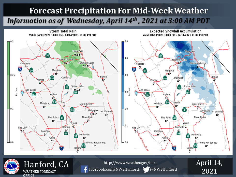
Projected Rainfall Totals for Yosemite Valley: 0.28"
April 14, 2021 - The National Weather Service Hanford Office reports a storm system will bring mountain rain and snow to parts of the Sierra Nevada from early this morning through later this evening.
Snow will mostly fall above 5,500 feet.
While the heaviest precipitation will fall near Yosemite National Park, measurable precipitation will reach as far south as Sequoia National Park by this afternoon.
Above are the latest projected rainfall and snowfall amounts.
  Area Forecast Discussion
  National Weather Service Hanford CA
  340 AM PDT Wed Apr 14 2021


  .SYNOPSIS...
  A closed low will bring a chance of light showers to the high
  Sierra through Wednesday. Winds will turn breezy again this
  afternoon across the Kern County mountains and desert. Cooler air
  will lower temperatures to near normal on Wednesday then a warming
  trend is expected to raise them to well above normal by the
  weekend.

  &&

  .DISCUSSION...
  Satellite images show a closed upper low over the Great Basin.
  This system will move slowly east and be the main weather feature
  for weather across the central CA interior. Radar indicated a
  couple of bands of precipitation south of Lake Tahoe and Reno.
  Showers were starting to develop just northeast of Hetch Hetchy in
  Yosemite Park this morning. Snow reported around 6000 feet near
  Lake Tahoe. Snow level may end up 5500-6000 feet across the
  southern sierra. The system is over land and lacks a source of
  moisture but appears very dynamic with disturbances moving around
  the upper low. Models indicated weak instability over the sierra.
  So thunder may be possible with several inches of snow over the
  sierra high country especially in the Yosemite Park area.
  Otherwise mainly light precipitation amounts expected in the
  remainder parts of the southern sierra. The low will track slowly
  eastward with cyclonic flow will remain over the sierra. Models
  show instability over the sierra with isolated showers possible
  each afternoon Thursday and Friday. Winds should pick up again
  this afternoon over the Kern County Mountains and desert as
  gradient increase with day time heating. Expect breezy, gusty
  winds below passes to be short lived and diminish during the early
  evening. The cooler temperatures are expected today and start
  warming Thursday. But will should feel spring like through
  Friday. A more significant warming will come in during the weekend
  as a ridge over the east Pacific build inland across much of the
  west.
Source: NWS

