


California and National Drought Summary for April 13, 2021
Summary
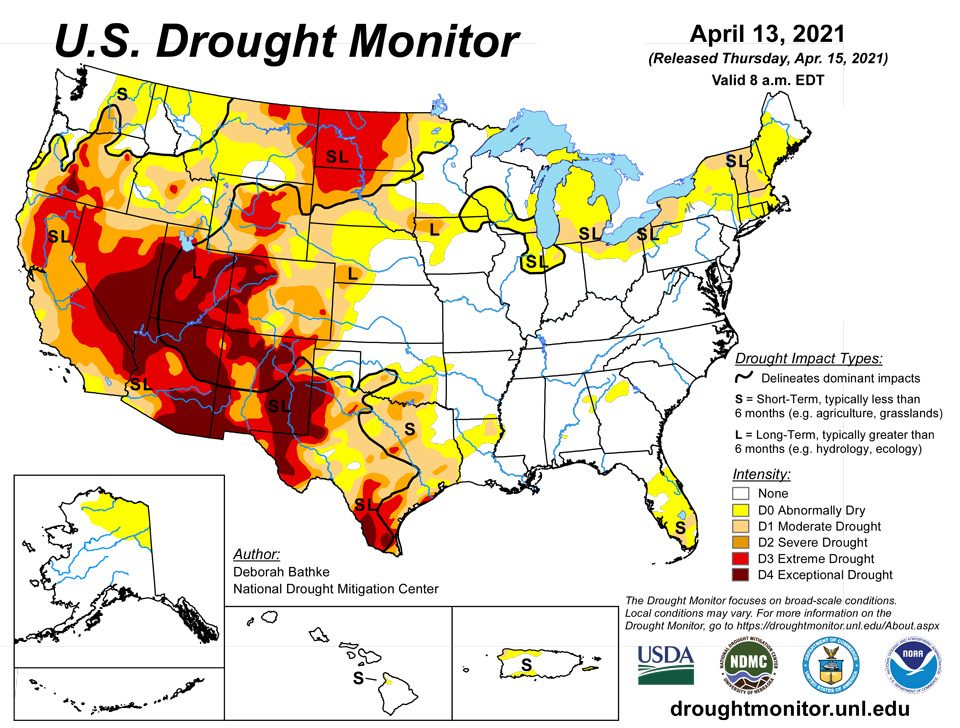
April 15, 2021 - Last week’s storm system brought heavy rain and thunderstorms to much of the central and eastern U.S., bringing drought condition improvements to parts of the Midwest and eastern Plains. Meanwhile, warm, dry conditions persisted in the West and New England, resulting in deteriorating conditions. Parts of the Southwest are now experiencing record levels of dryness for the last 12 months. In New England, year-to-date precipitation ranks in the top 10 driest on record.
Northeast
Warm, dry weather across New England led to the expansion of moderate drought (D1). Here, daytime high temperatures over the last week ranged from 6 to 19 degrees above normal. Year-to-date precipitation at many stations ranks in the top 10 driest, down about 3 to 5 inches below normal. This has led to very low soil moisture, reduced streamflow, and declining groundwater. New Hampshire state officials urged the public to conserve water in response to the growing deficits and are preparing to adopt restrictions if the dry conditions persist. Likewise, Massachusetts residents and business are also being urged to curb water use. Widespread precipitation across the Mid-Atlantic last week helped prevent additional degradations in drought areas and alleviate any pockets of developing dryness.
Southeast
Much of the region remains free of drought, with pockets of D0 (abnormal dryness). The only exception is southern Florida, where D1 (moderate drought) remains. Showers and thunderstorms across the region held off potential degradations, but the precipitation wasn’t enough to make up remaining deficits of about 1.5 to 4 inches of rainfall.
South
Showers and thunderstorms across the South last week led to slight improvements to D0 (abnormally dry) and/or D1 (moderate drought) in Louisiana and East Texas. While the rain helped some, shortages still exist at 60 to 90 days. Having missed out on the rainfall, conditions continued to deteriorate in south-central Oklahoma and in North, South and West Texas, where another week of warm, dry weather continued to build long-term deficits and further dried out soils.
Midwest
Widespread precipitation across the Midwest led to broad improvements to drought across the region, erasing moisture deficits and improving soil moisture and streamflow. Locally heavy totals (more than 2 inches) led to a two-category improvement in western Minnesota. These short-term gains also finally chipped away at the D3 (exceptional drought) area in northwestern Iowa that had been in place since October 2020. Cooperative Extension notes that tile lines are running again and water is standing in roadside ditches. Soil moisture has also started to rebound.
High Plains
The High Plains generally saw cooler than normal temperatures and widespread precipitation over the last week. Locally heavy amounts of rainfall (more than 2 inches) helped erase long moisture deficits in eastern South Dakota and southeastern North Dakota, resulting in improvements to moderate drought. In the remainder of the region, precipitation wasn’t enough to prevent worsening conditions. Moderate drought (D1) expanded in South Dakota and extreme drought (D3) expanded in both North and South Dakota to reflect the growing moisture deficits and its effect on soil moisture. Agricultural field reports indicate planters are being idled, except in the southeastern corner of the state, and cattle are being culled.
West
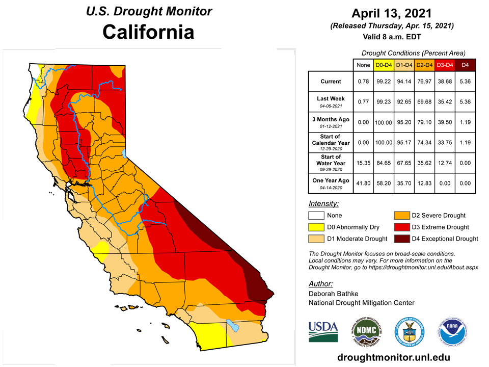
Once again this week, much of the West remained dry. Where precipitation did fall, in the Pacific Northwest and the Northern Rockies, it either missed the drought-inflicted areas or wasn’t enough to overcome shortages. The only exception was in north-central Wyoming and southern Montana, where last week’s snowfall lessened precipitation deficits and improved streamflow and soil moisture resulting in a one-category improvement to drought. In eastern Washington, D0 (abnormally dryness), D1 (moderate) and D2 (severe) drought expanded as precipitation deficits continued to increase, drying out soils and lowering streamflow. Conditions once again deteriorated in Oregon this week with expansions in D2, D3 (extreme) and D4 (exceptional drought). The warm, dry winter added to deficits that had been in place for more than a year, leaving soils extremely dry and limiting runoff. Crop condition reports that counties in the D3 and D4 regions are “heading into their worst water year ever for irrigators with the potential for large amounts of acres left fallowed.” Little to no water for irrigation is expected for Upper Klamath Lake this year. Similarly, drought also expanded in Idaho where a lack of precipitation for almost two months has limited runoff, resulted in earlier than normal snowmelt and put short-term precipitation below the 10th percentile at many locations. Drought conditions also expanded in northern and central California. Another week without rainfall has continued to build upon longer deficits. Cooperative Extension notes that the majority of the season’s creeks aren’t flowing and that stock ponds are still dry. Decreases in water allocation and reduced or negligible forage are causing producers to respond by culling and selling herds. Drought conditions are also prompting Cal Fire to bring in fire crews earlier in the season. Other changes to this week’s map include an expansion of D1 in western Wyoming, and D1, D2 and D3 in eastern Montana reflect the lack of precipitation over the last two to three months and its effect on soil moisture and streamflow. In the Southwest, D4 was expanded over southeast Arizona as another week of hot, dry weather showed its impact on streamflow, soil moisture, and vegetation. It’s worth noting that high temperatures ranged from 10 to 20 degrees above normal last week and that many areas are now at record dry levels for the past 12 months.
Alaska, Hawaii, and Puerto Rico
In Alaska, continued snowy conditions once again led to improvements along the southern and western edges of the abnormally dry area (D0) in the interior. In Hawaii, trade winds kept most of the rainfall confined to the east-facing windward slopes. Isolated, brief thunderstorms produced some rainfall on the leeward slopes, but the totals weren’t enough to keep conditions from deteriorating. Increasing rainfall deficits and declining vegetation health led to the expansion of D0 and the introduction of D1 on the Big Island. Puerto Rico also saw an expansion of D0 on the southwest part of the Island in response to growing rainfall shortages and low streamflow.
Pacific Islands
Following an extended period of slow organization, Tropical Storm Surigae (02W) formed while moving northwestward between Koror (Republic of Palau) and Yap (Federated States of Micronesia), passing near Ngulu Atoll on April 14. A broad moisture field surrounding the developing tropical circulation produced locally heavy showers across the Republic of Palau and Yap State, as well as neighboring islands. Farther north, however, only light precipitation fell across large sections of the Mariana Islands, where dryness (D0-S) and moderate short-term drought (D1-S) persisted. Meanwhile, significant drought continued to affect the northern islands in the Republic of the Marshall Islands, with Wotje remaining in extreme short-term drought (D3-S) and Kwajalein experiencing deterioration to severe drought (D2-S), compared to last week’s D1-S designation. Elsewhere, rainfall was sufficient to maintain drought-free conditions in all other areas, except Kapingamarangi (southernmost atoll in the Federated States of Micronesia), which is experiencing severe drought (D2-L) while continuing to slowly recover from acute long-term precipitation deficits.
In the Commonwealth of the Northern Mariana Islands, patchy showers embedded in a mostly dry trade wind pattern prevented further deterioration but did not provide much, if any, relief. Based on data from Guam International Airport, the Keetch-Byram Drought Index (KBDI) rose to 700 by April 14, up from 651 on April 5. KBDI values above 600 can be indicative of dryness/drought and potentially erratic fire behavior, when fires occur. From April 7-13, Guam International Airport received rainfall totaling just 0.20 inch, warranting a continuation of D0-S. On the west coast of Guam, the village of Agat received 2.04 inches during the same 7-day period. D0-S also persisted on Rota, where only 0.20 inch fell. Moderate drought (D1-S) continued across Saipan, where all reporting sites received less than an inch of rain from April 7-13.
In the Federated States of Micronesia (FSM), all islands were free of dryness and drought except Kapingamarangi, where long-term severe drought (D2-L) existed. Kapingamarangi, which endured the punishing effects of exceptional drought (D4) on crops and water supplies as recently as January 2021, has experienced slow recovery. Rainfall on Kapingamarangi has totaled at least 2 inches in four of the last 5 weeks, with more than 5 inches falling from April 7-13. Elsewhere in the FSM, most of the focus was on Tropical Storm Surigae, which led to the issuance of a Tropical Storm Warning on April 14 for Ngulu Atoll and Yap Island. Weekly (April 7-13) totals reached 8.12 inches at an observation site (North Fanif) in the Yap State municipality of Fanif and 7.76 inches on Woleai Atoll.
In the Republic of the Marshall Islands (RMI), water conservation measures remain in place on some northern islands. Wotje received 2.00 inches of rain from April 7-13 and reported a 2-week total of 3.02 inches. However, a protracted dry spell on Wotje since late 2020 warrants a continuation of extreme drought. On Kwajalein, where severe drought was introduced, there have been mostly only light rain showers since March 8-10, when 3.34 inches fell. Kwajalein’s rainfall from March 11 – April 13 totaled 3.16 inches. Although Kwajalein has high-quality water from reverse osmosis units, some neighboring islands are dependent on natural sources or water transported from Kwajalein. Ebeye, the most populous island of the Kwajalein Atoll, has experienced some water shortages, along with Mejatto and Ebadon. In addition, some crops on these islands are yellowing due to drought. Meanwhile, Majuro has turned drier in recent days, with a corresponding drop in reservoir storage. After peaking at 30.473 million gallons (85 percent of capacity) on April 3, Majuro’s storage fell to 27.218 million gallons (76 percent) by April 13. Majuro remains free of dryness, but short-term trends in rainfall and reservoir storage will need to be monitored.
Elsewhere, neither dryness nor drought is present across the Republic of Palau and American Samoa. Palau was on the periphery of nascent Tropical Storm Surigae, resulting in locally heavy showers. From April 7-13, rainfall at Palau International Airport totaled 5.54 inches. Meanwhile, slightly drier weather developed across American Samoa, with weekly totals less than 1.10 inches at all observation sites. However, earlier wetness in American Samoa currently precludes any dryness-related concerns.
Virgin Islands
Following some beneficial showers across the U.S. Virgin Islands in early April, mostly dry weather returned. In addition, some unusually dry air briefly overspread the islands. On April 10, for example, the dewpoint temperature fell as low as 57°F at Rohlsen Airport (TISX) on St. Croix, resulting in a relative humidity of 42 percent. On the same date, King Airport (TIST) on St. Thomas had a minimum dewpoint of 56°F. Weekly (April 6-12) rainfall totaled 0.01 inch at Rohlsen Airport and 0.16 inch at King Airport.
Among volunteer (CoCoRaHS) weather stations in the U.S. Virgin Islands, the highest April 6-12 total was 0.73 inch—all of which fell in a downpour on the 7th—along the northern shoreline of St. John at VI-SJ-3. Just miles away, near Cruz Bay, 0.12 inch fell during the drought-monitoring period at VI-SJ-5. According to the U.S. Geological Survey (USGS) well on St. John, depth to water has steadily increased throughout 2021 and is approaching 15.5 feet. Given the short-term dryness and groundwater shortages, severe drought (D2-S) persisted on St. John.
In recent days, depth to water on St. Thomas has stabilized near 13.35 feet, based on information from USGS well data. Aside from a period in 2020 when information was not available, depth to water has not been greater on St. Thomas since the summer of 2017, shortly before Hurricanes Irma and Maria devastated the U.S. Virgin Islands. During the drought-monitoring period, rainfall at four volunteer (CoCoRaHS) weather stations ranged from zero to 0.07 inch. Given the return to dry weather and lack of well recovery, St. Thomas retained a severe drought (D2-SL) designation.
On St. Croix, drought-monitoring period rainfall at all airport and volunteer (CoCoRaHS) sites totaled less than one-tenth of an inch. Depth to water at the USGS well on St. Croix increased to more than 22.4 feet for the first time since December 2016, although data was missing for part of 2020. As a result, the moderate drought (D1-SL) designation was maintained for St. Croix.
Looking Ahead
The National Weather Service Weather Prediction Center forecast for the next five days (April 15-19) shows slow moving storm systems affecting large parts of the Lower 48. This storm is expected to bring cold temperatures and late season snows across the Northern Plains, Central Rockies and Northern Great Basin. In the Southwest, dry weather combined with gusty winds is expected to persist, leading to an elevated fire risk. In contrast, the Lower Mississippi Valley and eastern Gulf Coast states are expected to see heavy rainfall. Moving into next week, the Climate Prediction Center six to 10 day outlook (valid April 19-23) favors above normal temperatures across the West, Northeast and Southeast. Below normal temperatures are most likely across the Great Plains, Midwest and Mississippi Valley. Below normal precipitation is expected across much of the country with the exception of the Southern High Plains, Florida and New England.
Author(s):
Deborah Bathke, National Drought Mitigation Center
Brad Rippey, U.S. Department of Agriculture
Dryness Categories
D0 Abnormally Dry—used for areas showing dryness but not yet in drought, or for areas recovering from drought.
Drought Intensity Categories
D1 Moderate Drought
D2 Severe Drought
D3 Extreme Drought
D4 Exceptional Drought
Drought or Dryness Types
S Short-term, typically less than 6 months (agriculture, grasslands)
L Long-term, typically more than 6 months (hydrology, ecology)
SL Area contains both short- and long-term impacts
Source: National Drought Mitigation Center

