


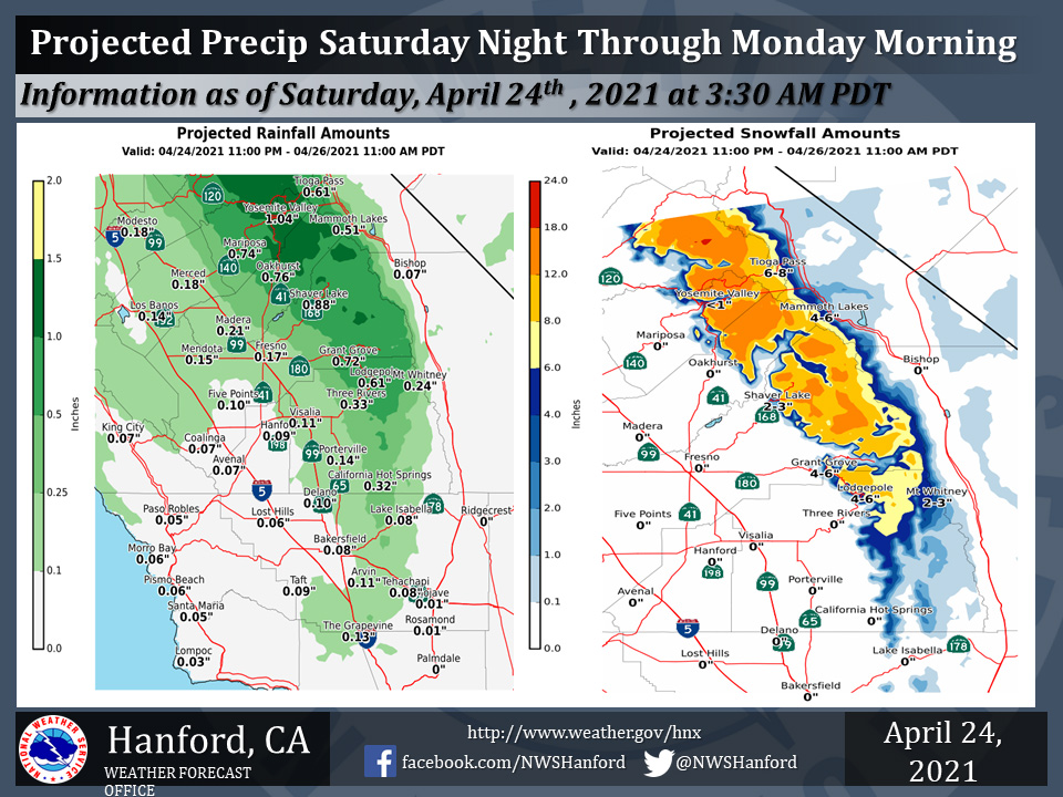
Projected rainfall totals for Mariposa: 0.74"
Projected rainfall totals for Oakhurst: 0.76"
Projected rainfall totals for Yosemite Valley: 1.04"
April 24, 2021 - The National Weather Service Hanford Office reports a storm system will impact Central California Saturday night through Monday morning.The majority of precipitation associated with this storm system will fall Sunday.
Snow levels will start at around 6,000 feet Saturday night, before falling to about 5,000 feet Sunday night
  Area Forecast Discussion
  National Weather Service Hanford CA
  424 AM PDT Sat Apr 24 2021


  .SYNOPSIS...
  A storm system will bring rain and mountain snow to the region
  from late tonight into Monday morning along with unseasonably
  cool high temperatures Sunday and Monday. Dry weather and a day to
  day warming trend will occur Tuesday through the end of next
  week. High temperatures of ninety degrees or warmer are likely in
  the San Joaquin Valley, lower foothills and the Kern County desert
  by Thursday.

  &&

  .DISCUSSION...
  Shortwave energy pushing into northern California ahead of a
  northeast Pacific low pressure system is spreading mid and high
  cloudiness across our region while radar indicates some light
  precip/virga brushing by our northern sections. Temperatures are
  running up a couple of degrees over much of our area beneath the
  increased cloud cover. Tightening onshore surface pressure
  gradients associated with the incoming trough are producing
  increasing southwest to west gusty winds across the mountains and
  desert areas of Kern County.

  The shortwave trough will continue to push inland today while the
  northeast Pacific low pressure system swings southeastward toward
  the coast. Onshore pressure gradients will continue to strengthen
  and gusty winds will further increase, so a Wind Advisory is in
  effect for the Kern County desert areas beginning at noon today.

  Model solutions are consistent with the incoming low pressure
  system, bringing it ashore by early Sunday morning and swinging it
  inland through Monday. Showers are expected to spread southward
  into central California overnight and affect all of our area by
  Sunday. There is little change in forecast precipitation amounts,
  with Valley locations expected to receive around 1/10 to 1/4 of an
  inch, lighter on the west side. Amounts will increase in higher
  elevations of the Sierra, with up to 3/4 of an inch in the
  foothills and around 1 inch at higher elevations. Snow levels will
  run around 6000 ft and we can expect 6-12 inches of snowfall
  accumulating north of Kings Canyon, up to 18 inches at the highest
  elevations. A Winter Storm Warning is therefore in effect for this
  area 2 AM Sunday to 11 AM Monday. Snow fall amounts farther south
  in Tulare County will be lesser, with around 3-7 inches expected,
  and A Winter Weather Advisory is in effect there 5 AM Sunday to 11
  AM Monday.

  The passing system will maintain the gusty wind pattern and the
  Wind Advisory for the Kern County desert will remain in effect
  through 6 PM Sunday. Precipitation will taper off, with just some
  lingering Sierra showers by Monday evening. Temperatures will also
  trend downward through the weekend, a couple of degrees below
  normal today then likely to reach around 15-20 degrees below
  normal on Sunday. Dry and warming conditions will follow the
  exiting system for early next week, with temperatures up to 4-8
  degrees above normal by Wednesday.

  As high pressure strengthens over our area, temperatures will
  continue to warm into the end of the week. By Friday there is
  around a 65 percent probability of high temperatures into the
  lower 90s across the San Joaquin Valley, lower foothills and
  desert areas.
Source: NWS
