


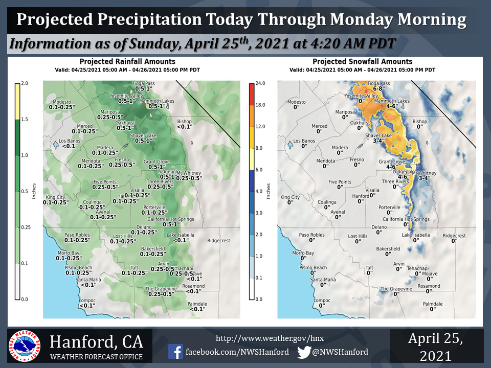
Projected rainfall totals for Mariposa: 0.25" to 0.50"
Projected rainfall totals for Oakhurst: 0.50" to 1.00"
Projected rainfall totals for Yosemite Valley: 0.50" to 1.00"
April 25, 2021 - The National Weather Service Hanford Office reports a storm system will continue to impact Central California through Monday morning.The majority of precipitation associated with this storm system will fall today.
Snow levels will start at around 6,000, before falling to about 4,000 feet Monday morning.
  Area Forecast Discussion
  National Weather Service Hanford CA
  345 AM PDT Sun Apr 25 2021


  .SYNOPSIS...
  A storm system will move into the region this morning, and will
  continue through Monday morning. This system will bring some very
  beneficial precipitation for the entire district, as well as below
  average temperatures on Sunday and Monday. Dry weather will
  return by Tuesday as temperatures trend up. Temperatures will then
  increase to well above average by mid- week into the weekend.

  &&

  .DISCUSSION...
  Change in the weather is occurring across Central California as
  precipitation is once again being observed. Currently, very light
  precipitation is starting to reach the Yosemite NP area along with
  portions of Merced, Mariposa and Madera Counties. Regional Radar
  estimated precipitation rates are showing mainly trace amounts.
  Upper-air analysis, along with satellite IR imagery is showing the
  upper low still off the West Coast and expected to make landfall
  this morning. Until the upper low makes landfall the district will
  be under the influence of the warm sector ahead of the advancing
  cold front. This has allowed surface temperatures across the area
  to remain in the 50s along with a lull in winds. Once the upper
  low makes landfall and begins pushing ashore, the cold front near
  the Northern California coast will begin sweeping through the
  state and is expected to move pass Kern County before sunset.

  Unsettled weather conditions are expected this Sunday, mainly,
  during the passage of the cold front across the region. The light
  precipitation currently being observed will become heavy at times
  during cold frontal passage along with stronger winds. Precip-
  water satellite imagery is showing a good plume of higher moisture
  values pushing in from the west. Therefore, support will exist on
  having the heavier precipitate rates today as a surge of cold air
  invades the Central California Interior. This combination will
  allow for Winter-like conditions to exist across the Sierra Nevada
  as significant snowfall is expected today. Weak Atmospheric River
  conditions along with a +100 knot jet max will provide good
  orographic (mechanical) lift of the higher moisture values
  entering the district. Therefore, even with the movement of the
  upper low remaining north of the district and keeping the bulk of
  its dynamic energy over Northern California, enough energy could
  sweep through the area as a very high potential of receiving
  widespread measurable precipitation will exist.

  Furthermore, instability will increase during cold frontal
  passage this afternoon. A threat of thunderstorms will exist and
  could reach as far south as the San Joaquin Valley portion of Kern
  County. Along with the other unsettled weather conditions,
  temperatures this afternoon with is poor recovery and may not rise
  much higher then where they will be at sunrise. This surge of
  cold air will also allow for snow level to reach the 5000 foot
  level for late April. Yet, being late April, the cold air
  conditions will be short-lived as the area will quickly rebound by
  mid-week.

  Tuesday may still see lingering effects of the storm as ensembles
  are still leaning in the direction of another ridge pattern by
  mid-week. Having to deal with a closed low, uncertainty is still
  to high to call the next ridge a blocking pattern, yet, the
  ensemble mean is attempting to develop and then break down the
  ridge toward next Friday. At the moment, will lean in the
  direction of keeping the ridge pattern in existence over the West
  Coast for the remainder of next week. Therefore, will see
  precipitation in the short term and then return to a dry pattern
  for the remainder of the forecast period.
Source: NWS

