


California and National Drought Summary for April 27, 2021
Summary
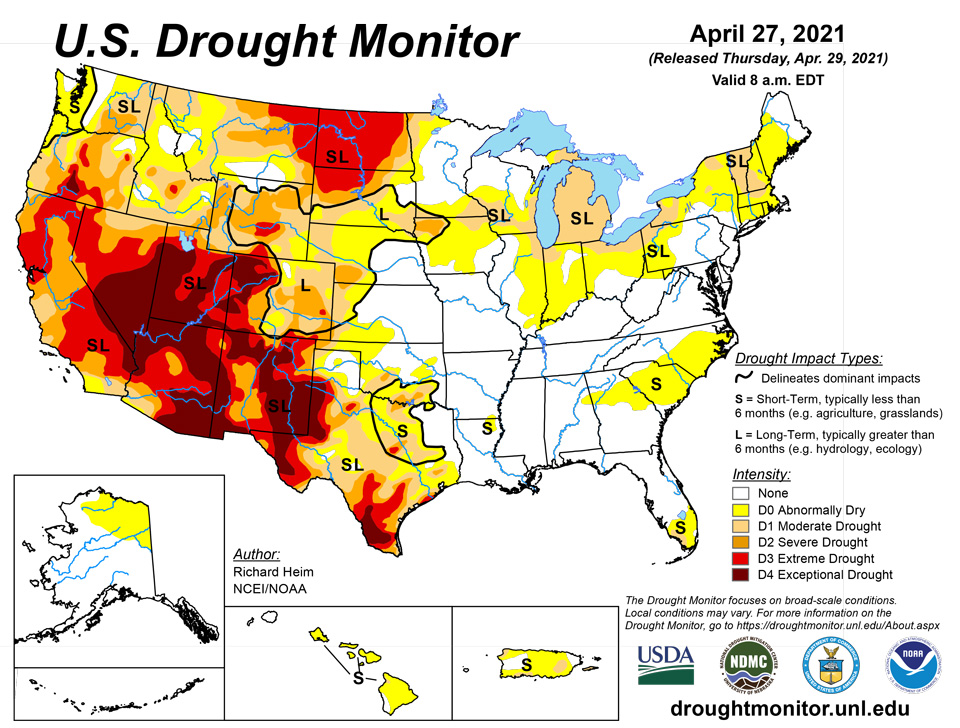
April 29, 2021 - Several upper-level troughs and closed lows moved in the westerly jet stream flow across the contiguous U.S. (CONUS) during this U.S. Drought Monitor (USDM) week. They dragged surface fronts and low pressure systems along with them. The weather systems moved across the West then generally followed two storm tracks after crossing the Rockies – one track was along the Canadian border, while the other track was along the Gulf Coast states. As a result, above-normal precipitation fell across parts of the West, much of the Gulf Coast from eastern Texas and Oklahoma to Georgia, parts of the Mid-Mississippi Valley, and parts of the northern Great Lakes and Maine. Precipitation amounts were generally 0.5-2.0 inches in the West where precipitation fell, but exceeded 2 inches across a large part of the Gulf Coast states. The rest of the CONUS had below-normal precipitation for the week. A swath from New Mexico to Lower Michigan, and parts of the northern Plains and Far West, had little to no precipitation. With upper-level troughs and surface cold fronts dominating the circulation pattern, weekly temperatures averaged below normal across most of the CONUS. Drought or abnormal dryness contracted in parts of the southern Plains to Southeast, where heavy rains fell, and in parts of the northern Plains and Northeast, where overall conditions warranted improvement. But drought or abnormal dryness expanded or intensified across parts of the West, Midwest, other parts of the Plains, and the Carolinas, as well as much of Hawaii and Puerto Rico. In these areas, precipitation deficits grew and soils continued to dry. These changing conditions were reflected in several drought indices and indicators, including the Standardized Precipitation Index (SPI), streamflow and groundwater levels, soil moisture measurements on the ground and from satellite as well as soil moisture models, vegetation-based indices such as VegDRI, and mountain snow water content (SWE) in the West.
Northeast
Precipitation fell across most of the Northeast this week, but amounts varied considerably. An inch or more was observed across parts of northern New England, and there were patchy areas of 0.5-1.0 inch, with many other areas receiving less than 0.5 inch. Topsoil improved in some areas and worsened in others, increasing to 61% of Maine with topsoil moisture short or very short (dry or very dry) and 25% of New Jersey, according to U.S. Department of Agriculture (USDA/NASS) statistics. Dry topsoil percentages improved slightly but were still high in New Hampshire (55%), Connecticut (28%), and Massachusetts (26%). D1 was pulled back slightly in western and northeastern New York, while D0 expanded across southwest Pennsylvania into West Virginia. In Massachusetts, 2021 Phase II water restrictions were now in effect in the town of Mansfield and other communities, while in New Hampshire, “concerningly low levels” of aquifers prompted the city of Dover to urge voluntary water conservation.
Southeast
Rain soaked Alabama and Georgia and adjacent parts of South Carolina, where 2+ inches covered large parts of the states and streaks of 5+ inches occurred in southern portions. Parts of central Florida and the panhandle received 1 to locally 2+ inches, while 0.5-1.0 inch fell across North Carolina and Virginia. Dry areas included eastern North Carolina and adjacent parts of Virginia and South Carolina, as well as parts of Florida, where a half inch or less of rain was noted. Abnormal dryness contracted in Alabama, Florida, and Georgia, but expanded in eastern North Carolina. Moderate drought expanded in far southwest Florida where 1- to 3-month precipitation deficits were significant. USDA statistics revealed 46% of South Carolina’s topsoil was short or very short, while the value was 24% for Florida.
South
In the southern Plains, the western half of Texas and Oklahoma were dry this week, with little to no rain falling. But a half inch or more of rain was widespread across the rest of the South, with 2+ inches in streaks across eastern Oklahoma and Texas, Arkansas and Louisiana, and southern Mississippi. D0-D3 contracted in eastern Texas, D0-D2 contracted in parts of Oklahoma, D1 disappeared and D0 contracted in Louisiana. But further west, D0-D4 expanded in southern and southwest Texas and D0 expanded in western Oklahoma. Dry or very dry soils grew in area to 67% of Texas and 29% of Oklahoma, according to USDA statistics, and 43% of the winter wheat crop in Texas was in poor to very poor condition. In the Midland-Odessa, Texas, area, 2020-2021 had the driest 13-month April-April period on record, and the fourth driest any 13-month period ever (behind 2011 which had the top 3 driest 13-month periods). Falling levels of the Edwards Aquifer triggered water restrictions in several Texas communities, including San Antonio, New Braunfels, and San Marcos.
Midwest
In the Midwest, a half inch of precipitation fell along the Ohio and Mid-Mississippi Rivers, parts of northern Ohio and Indiana, and central Minnesota to Upper Michigan. Parts of far northern Wisconsin had an inch or more. But much of the Ohio Valley states, and Iowa to Lower Michigan, had little to no precipitation this week. Streamflow, soil moisture, and 1- to 2-month SPI indicators prompted expansion of D0 in Illinois, Indiana, and Ohio, while D1 expanded in northern parts of Indiana and Illinois, across southern Wisconsin, into southeast Minnesota and northeast Iowa where deficits were mounting as seen in 1- to 4-month SPI values. D0 also expanded in the latter 3 states. D1 was expanded across Lower Michigan where precipitation deficits over the last 90 days have been building, streams are low, and soil moisture continues to dry. USDA statistics show 30% of the state is experiencing topsoil moisture that is short to very short (dry to very dry), an increase of 17% over the last week. The statistics increased to 34% in Iowa, 25% in Minnesota, and 21% in Wisconsin.
High Plains
There were patches of 0.5-1.0 inch of precipitation in southeast Kansas, the Dakotas, Wyoming, Colorado, and the western half of Montana this week. But most of the region was dry, with less than 0.25 inch of precipitation falling. With improving conditions in the short-term (last 1-6 months), D0-D2 were pulled back in parts of South Dakota and northeastern Wyoming. But D4 expanded in northwest Colorado, and D3 expanded in eastern North Dakota where this week was dry and 6-9-month SPI are D3-D4, deeper soils are bone dry, streams are low, and stock ponds are dry or almost empty. D1-D3 expanded in northern Montana, D0-D2 expanded in western Wyoming, and D0 expanded in southwest Kansas. In the Montana Highline, reports were received from Blaine and Hill Counties of low soil moisture and stockwater ponds failing to fill. Three dozen reports were received from North Dakota, through the Condition Monitoring Observer system, of drying ponds and creeks, hay and feed shortages, and fire risk. USDA statistics rate more than half of the topsoil short or very short of moisture in Colorado (57%), Montana (57%), and Wyoming (55%), and nearly two-thirds or more so rated in South Dakota (62%) and North Dakota (80%); 32% of the winter wheat crop in Colorado was rated in poor to very poor condition. Several Colorado communities were asked to voluntarily conserve water.
West
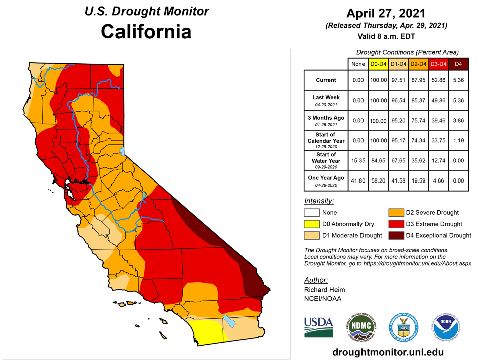
Precipitation amounts from the Pacific weather systems that moved across the West this week were patchy and not enough to erase months of deficits. Half an inch to locally 2 inches fell across coastal areas and coastal ranges of Oregon, Washington, and northern California; in the Sierra Nevada; northern and central Rockies; and Great Basin ranges. Rainshadow areas and valleys, and much of the Southwest, received little to no precipitation. There were minor contractions of D4 in New Mexico and D0 in Idaho, but worsening dry conditions prompted expansion of drought and abnormal dryness in several western states. D1-D3 expanded along the northern California coast, D0-D2 expanded in the Pacific Northwest, and D3 expanded in western New Mexico. In California, the Marin Municipal Water District board unanimously approved mandatory restrictions for its 195,000 customers in south and central Marin County which would take effect on May 1. The goal was to curb overall district-wide water use by 40%. The potential for water shortages in Marin County was so high that the Marin Municipal Water District was talking with East Bay officials about building a pipeline across the Richmond-San Rafael Bridge to bring water into the county if the upcoming winter is similarly dry as the past two. Such a measure was used during the 1976-77 drought. Record low reservoir levels contributed to California Governor Gavin Newsom proclaiming a regional drought emergency for the Russian River watershed in Sonoma and Mendocino counties. A super bloom of lupine covered parts of the Folsom Lake lakebed in the Beeks Bight nature area in Granite Bay as historically low rainfall left the lake unusually low. Folsom Lake is at 37% of capacity and 50% of the historical average for April 27, according to the California Department of Water Resources Data Exchange Center. Shallow wells were going dry in the San Joaquin Valley, while Tulare County ranchers were culling cattle for sale months earlier than usual and were considering idling row crops to leave water for higher-value permanent crops like nut trees. The prolonged drought is causing significant die-offs of juniper trees in large areas of central and northern Arizona, according to Forest Service officials. Between 50,000 acres and 100,000 acres of junipers were affected in areas of the Prescott and Kaibab national forests between Paulden and Ash Fork and north of Williams. The cause of death appeared to be water stress, although some insects were observed. Die-offs ranged from 5% to 30% of the tree population, with some pockets of dead junipers up to 15 acres. USDA statistics showed increases in the percentage topsoil moisture short or very short – up to 89% in New Mexico, 70% in California, 69% in Oregon, 61% in Washington, 50% in Utah, and 32% in Idaho. According to media reports, the Biden-Harris administration announced the formation of an Interagency Working Group to address worsening drought conditions in the West and support farmers, Tribes, and communities impacted by ongoing water shortages. The Working Group will be co-chaired by the Departments of the Interior and Agriculture to build upon existing resources to help coordinate across the federal government, working in partnership with state, local, and Tribal governments to address the needs of communities suffering from drought-related impacts. The Working Group will work to identify immediate financial and technical assistance for impacted irrigators and Tribes.
Alaska, Hawaii, and Puerto Rico
The week was dry and warmer than normal across Alaska, but since this is the dry season and snowpack in most areas (except the north) was near or higher than normal, no change was made to the depiction in the state. D1 was added in eastern Puerto Rico and Vieques and expanded in the southwest, and D0 expanded almost island-wide, due to below-normal precipitation, rapidly dropping stream levels, low groundwater levels, and expanding dry soils. Reports have been received of grass fires and a decreasing trend in reservoirs. This week continued a dry trend in Hawaii, which has resulted in plummeting streamflow levels on many islands (except Kauai) and deteriorating pasture conditions on the Big Island. D0 expanded across Maui County, Oahu, and the Big Island, with D1 pushing up the slope to Waimea town on the Big Island.
Pacific Islands
Koror, Palau had 1.43 inches of rain this week, resulting in a month-to-date rainfall total of 20.95 inches. Drought free conditions remain since the month-to-date total exceeds the monthly 8 inches threshold to meet most water needs.
Dry conditions persisted across parts of the Marianas this week, with Saipan’s manual gauge (0.23 inch) and Rota (0.45 inch) receiving less than half an inch of rain. Guam and Saipan’s NPS had the most rain at 0.85 inch and 1.35 inches, respectively. Since this week marked Rota’s third consecutive week with rainfall totals less than half an inch, Rota's drought classification was changed to moderate short-term drought, while Guam and Saipan continued in moderate short-term drought.
Across the Federated States of Micronesia, Pohnpei, Kosrae, Lukunoch, Kapingamarangi, and Nukuoro had a wet week with rainfall totals surpassing 4 inches. Although Kapingamarangi has been receiving beneficial rains the last three weeks, it continued in moderate long-term drought as vegetation in the region continues to recover. Meanwhile, the other locations continued in drought free conditions. Chuuk Lagoon had over 1 inch of rain this week, while Yap, Fananu, Pingelap, Ulithi, and Woleai had less than 1 inch of rain. Although this was a dry week for these locations, drought is not a concern at this time.
This was a dry week for the Marshall Islands with little to no rain in some locations. Kwajalein had the most rain at 1.39 inches, while Jaluit and Wotje had no rain. Wotje’s lack of rain secured another week of extreme short-term drought, while Kwajalein continued in severe drought. The other locations continued to be drought free.
Pago Pago had less than 1 inch of rain, while Siufaga Ridge and Toa Ridge had 1.43 and 1.45 inches, respectively. Drought free conditions continued across Tutuila as the month-to-date rainfall totals surpassed the threshold of 4 inches to meet most water needs.
Virgin Islands
Rainfall was meager across the USVI this week, with rainfall totals ranging between 0.07 - 0.20 inch across St. Thomas and St. John. The Henry Rohlsen airport at St. Croix had only 0.04 inch of rain, while the CoCoRaHS stations had a bit more at 0.51-0.73 inch. Month-to-date rainfall totals at Cyril E. King Airport at St. Thomas was at 81.8% of normal rainfall, while year-to-date was at 57.9% of normal. Henry Rohlsen airport (St. Croix) month-to-date rainfall total was 34.5% of normal, while year-to-date was 54.9% of normal. Groundwater levels have continued to decrease, reaching levels last seen in 2016. SPI values for Cyril E. King airport at the 3, 9, and 12-month periods were indicative of abnormally dry conditions. The Henry E. Rohlsen airport's SPI values at all levels were indicative of abnormally dry conditions to moderate drought. The Windswept Beach, St. John's SPI values were indicative of abnormally dry conditions to moderate drought at the 3,6, and 12 month periods. Severe short and long-term drought continued to affect St. Thomas and St. Croix, while St. John remained in severe short-term drought.
Looking Ahead
A large low pressure trough moving out of the Southwest triggered areas of rain across parts of the southern and central Plains into the Midwest, and another system spread precipitation across the Northeast, as the new USDM week began. During April 29-May 3, another Pacific system will move into the country. These weather systems are forecast to spread an inch or more of precipitation across the southern Plains, Lower to Mid-Mississippi Valley, Tennessee and Ohio Valleys, southern Great Lakes, and Northeast. Bands of heavy precipitation – 3 inches or more – are expected across Texas to Arkansas and along the Ohio River. An inch or more of precipitation is projected to fall across parts of northeast Colorado, Wyoming, and northwest Washington. Half an inch or less of precipitation should fall across the Southeast from Florida to Virginia, New Mexico to the central Plains, the rest of the Great Lakes, and central to northern Rockies. No precipitation is forecast to fall over much of the northern Plains and most of the rest of the West. Temperatures are predicted to be near to above normal for the week across the CONUS. The outlook for May 4-8 shows drier-than-normal weather is favored for much of the West to Great Plains with wetter-than-normal conditions for most of the Mississippi River to East Coast region. Warmer-than-normal weather is likely across most of the western, southern, and East Coast states, except for the Mid- to Upper-Mississippi Valley, Great Lakes, and New England. Odds favor wetter-than-normal weather for southern Alaska and cooler-than normal weather for most of the state.
Author(s):
Richard Heim, NOAA/NCEI
Ahira Sanchez-Lugo, NOAA/NCEI
Dryness Categories
D0 Abnormally Dry—used for areas showing dryness but not yet in drought, or for areas recovering from drought.
Drought Intensity Categories
D1 Moderate Drought
D2 Severe Drought
D3 Extreme Drought
D4 Exceptional Drought
Drought or Dryness Types
S Short-term, typically less than 6 months (agriculture, grasslands)
L Long-term, typically more than 6 months (hydrology, ecology)
SL Area contains both short- and long-term impacts
Source: National Drought Mitigation Center

