


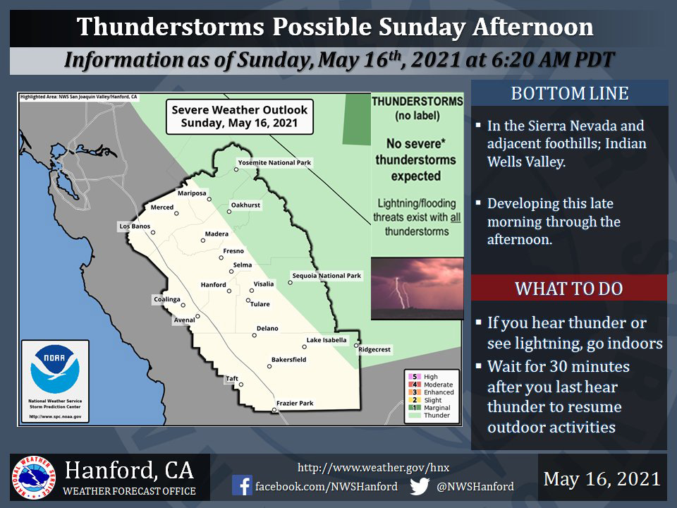
Includes Eastern Mariposa and Madera Counties and Yosemite National Park
Small hail and wind gusts near 40 miles per hour are a couple of hazards associated with strong thunderstorms.
In addition to dangerous cloud to ground lightning strikes, any thunderstorm can produce intense rainfall rates, leading to localized flooding.
  Area Forecast Discussion
  National Weather Service Hanford CA
  124 AM PDT Sun May 16 2021

  .SYNOPSIS...
  Low pressure will move southeastward across the region today
  with showers and thunderstorms a good bet over the Sierra
  and Indian Wells Valley this afternoon. As the low moves east into
  the Four Corners region on Monday, left over moisture over the
  Sierra will allow for some additional afternoon showers and
  thunderstorms. Temperatures will be below normal today however a
  warming trend will begin Monday and Tuesday as high pressure
  becomes reestablished over the West. Another trough of low
  pressure will bring cooling temperatures beginning Wednesday with
  below normal values expected later in the week.

  &&

  .DISCUSSION...
  Nicely formed area of low pressure is well noted on water vapor
  imagery spinning around its center over the San Joaquin Valley
  early this morning. Around the periphery of the low radar shows
  some snow showers over the Sierra crest from the northern edge of
  Kings Canyon Park to Yosemite. This low will be the main driving
  factor today for the development of showers and thunderstorms
  later today as plenty of colder air aloft will bring instability
  to the Sierra.

  Forecast models move the low pressure center southeast across
  Kern County later this morning and this afternoon and the
  resulting northerly flow (and the best instability due to cold air
  aloft) behind the low will likely move and/or form thunderstorms
  across the Indian Wells Valley this afternoon and early evening.
  Model forecast precipitation totals will range from zero to as
  much as 0.50" in heavier showers and thunderstorms. Again most
  areas in the Sierra and desert won`t receive measurable
  precipitation however a some will. The remainder of the area will
  have mainly partly cloudy conditions with much remaining at or
  just below normal.

  On Monday, models are in good agreement in moving the low quickly
  east across Arizona with heights making a quick rise as a short
  wave ridge edges in from the west. Flow into the Sierra will be
  from a northerly direction. This will allow for some additional,
  but not nearly as widespread as today, showers and thunderstorms
  with the remainder of the area remaining dry and warming up a few
  degrees. Continuing the warm up, on Tuesday the short wave ridge
  reaches its maximum heights over Central California Interior thus
  the warmest day of the upcoming week will occur. No real extremes
  of heat this week as values on Tuesday will be just slightly above
  normal.

  Wednesday will mark the beginning of another cool down as a
  trough of low pressure pushes into the Pacific Northwest and then
  on Thursday and Friday a robust area of low pressure moves into
  the north state and Great Basin. Central California Interior
  should remain dry, however a cooler than normal period of weather
  will be the result.
Source: NWS

