


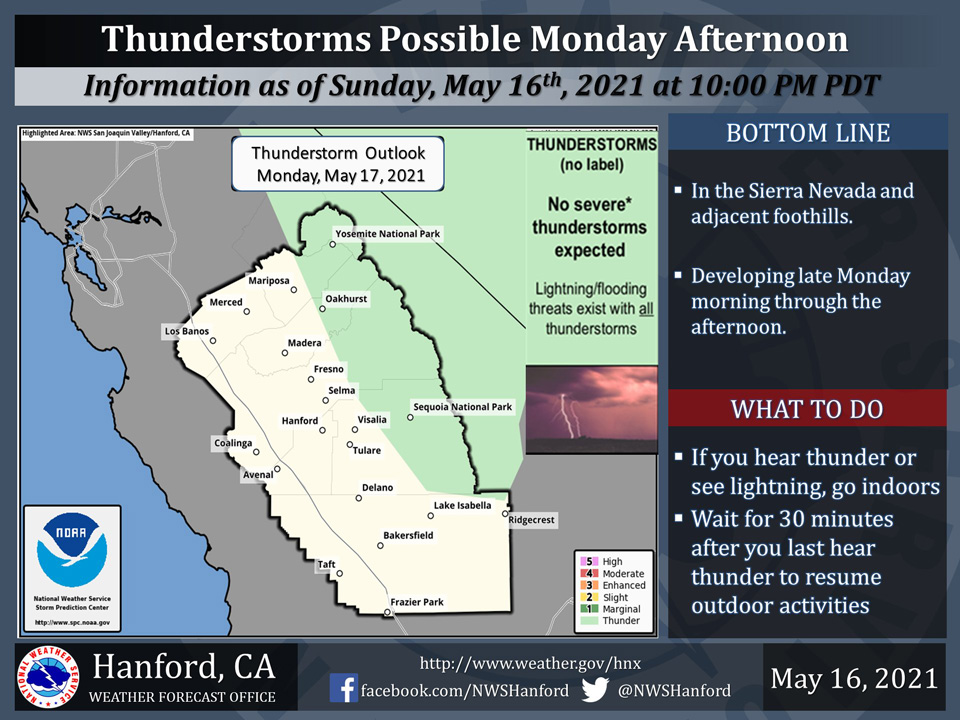
Includes Eastern Mariposa and Madera Counties and Yosemite National Park
Deadly lightning, brief downpours, small hail, and wind gusts near 40 mph will be possible. If you hear thunder, go indoors.
  Area Forecast Discussion
  National Weather Service Hanford CA
  132 AM PDT Mon May 17 2021


  .SYNOPSIS...
  Showers and thunderstorms are possible again this afternoon over
  the Sierra Nevada as instability aloft remains in place. Brief
  warming trend through Tuesday as high pressure builds. A slow
  moving trough will impact the region later in the week, sending
  afternoon high temps down into the mid 70s. Afternoon highs should
  rebound by the weekend as the trough slowly weakens and exits the
  area.

  &&

  .DISCUSSION...
  Another round of afternoon thunderstorms is in store for the
  Sierra Nevada and adjacent foothills this afternoon as instability
  on the backside of the trough remains over the area. However, areal
  coverage may not be as large as yesterday due to the trough
  exiting the area with shortwave high pressure moving in. Afternoon
  highs will rise several degrees today from yesterday`s highs as a
  result of the building ridge. The ridge axis will be directly
  overhead by Tuesday afternoon, so expect highs to rise a bit
  again, likely into the upper 80s for most of the San Joaquin
  Valley and low to mid 90s across the Mojave Desert.

  By Tuesday night, a trough of low pressure will dig southward from
  Western Canada and will begin impacting the area Wednesday, which
  will lead to a period of breezy conditions in the wind-prone areas
  of the CWA through Friday. Afternoon highs will drop accordingly
  as the trough approaches, and NBM guidance is forecasting highs
  ranging from 77-83 degrees for the valley, with the upper 70s
  occuring in Merced County. Increasing onshore flow overnight
  Wednesday and lowering 500 mb heights will send afternoon highs
  into the low to mid 70s for the valley for Thursday, which will be
  around 5-10 degrees below average for this time of the year. The
  upper low is forecast to meander southward on Friday, with the
  cold core likely centering over central Nevada. This will give a
  bit of a boost to the instability over the mountains due to the
  cold air aloft being closer in proximity to the Sierra Nevada, so
  afternoon thunderstorms are possible in the mountains Friday. A
  bit of a blocking pattern will prevent the trough from quickly
  leaving the area on Friday and Saturday, so expect a slow rebound
  in afternoon high temperatures over the weekend. On Sunday, EPS
  and GEFS guidance is showing the upper trough weakening and
  opening up into an open wave. It is then forecast to exit the area
  Sunday afternoon or Sunday night, which will allow for a bit of a
  warm up early next week. Blended model guidance is showing highs
  around 90 for next Monday, however this is subject to change some
  as there is some uncertainty in just how long the trough takes to
  leave the area on Sunday.
Source: NWS

