


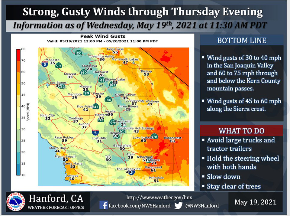
Mariposa Wind Gusts Up To 24 MPH
Oakhurst Wind Gusts Up To 26 MPH
Yosemite Valley Wind Gusts Up To 36 MPH
May 19, 2021 - The National Weather Service Hanford Office reports strong, gusty westerly winds will impact much of the central California interior through Thursday evening and create difficult driving conditions for motorists.
In addition, the wind will create areas of blowing dust in the SJ VLY and the Kern Co desert.
Here is a graphic of forecast peak gusts.
  Area Forecast Discussion
  National Weather Service Hanford CA
  320 AM PDT Wed May 19 2021


  .SYNOPSIS...
  A storm system will bring blustery, unseasonably cool weather to
  the district during the next few days. Strong and gusty winds will
  frequent the Kern county mountains and desert and the west side
  of the San Joaquin Valley through Thursday evening. The storm will
  also bring a chance of showers and thunderstorms to the Sierra
  from late Thursday through Saturday with the possibility of a few
  inches of snow above 6,000 feet.

  &&

  .DISCUSSION...
  Strong winds continue to blow across the Kern County Mountains
  and Desert this morning with breezy winds being felt across most
  of the district. The cold front associated with the current strong
  winds is situated over Kern County and continues to push south
  this morning. Based on the movement of the cold front and the
  resultant surface pressure gradient from KSFO to KLAS running at
  near 14mb, support for the High Wind Warning will remain in effect
  at least through 6 AM PDT this morning. Following the strong
  winds, temperatures will now start a cooling trend that will
  continue through the end of the week. A disturbance approaching
  the region toward the end of the week will introduce unsettled
  weather conditions to the mountains before another ridge enters
  the region next week.

  Ensemble model coming into better agreement with the closed low
  solution over California by the end of the week. Based on the
  possible trajectory of the low, winds may continue to be an issue
  as the Central California Interior will reside under a cyclonic
  flow pattern. At the same time, lowering temperatures may be
  favored over much of the district while any possible precipitation
  will remain over the higher terrain of the Sierra Nevada. While
  moisture will be lacking, enough moisture will be noted for
  isolated showers during the event as the upper low will not take
  an oceanic route. Yet, models are leaning more in the direction of
  possible wrap-around moisture that will sweep across the district
  during the Thursday and Friday precipitation events. Therefore,
  along with the area of best instability (CAPE), the Sierra Nevada
  will see a jet perpendicular of the mountain range to provide the
  area with mechanical lift. Therefore, the three ingredients will
  come into phase over the Sierra Nevada Crest for some afternoon
  convective (possible thunderstorm) conditions on for the days in
  question.

  Being a closed low, models confidence began to lower early next
  week as the low moves closer to the Four Corners region. While
  ensemble members begin to drift on the exact trajectory,
  confidence in the closed low exiting the district remains high as
  unsettled weather conditions diminish. Longer-range models
  continue to lean in the direction of another ridge pattern over
  the West just before mid-week. Will hold off on any big warm-ups
  until ensemble members agree on the ridge pattern solution.
Source: NWS
