


California and National Drought Summary for May 18, 2021
Summary
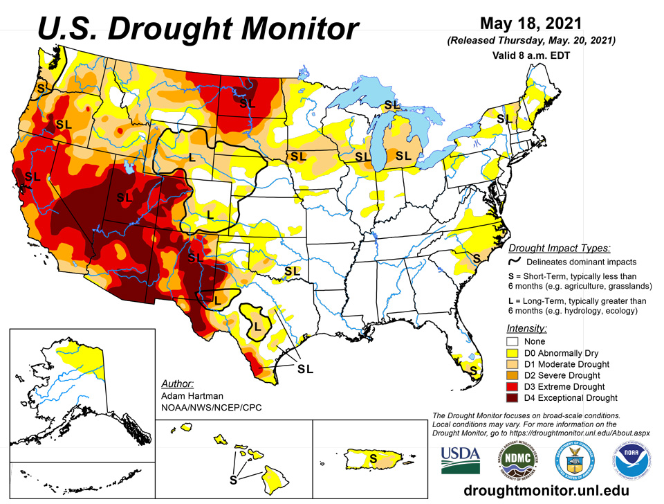
May 20, 2021 - Troughing over the western CONUS and ridging over the East resulted in strong southerly flow over the Southern and Central Plains, leading to widespread heavy rainfall (0.5 to 3 inches, and more) over portions of the Great Plains, Lower Mississippi Valley, and into western areas of the Corn Belt this week. The heaviest precipitation fell over southeastern Texas and southern Louisiana, where some locations received over 10 inches of rainfall. The heavy rainfall resulted in widespread removal and improvement in drought conditions from the Front Range eastward to Nebraska and Kansas, and southward to the Mexico border. Unfortunately, the moisture was unable to make it farther north than Nebraska, resulting in continued degradations across the Northern Plains, Upper Midwest, and Great Lakes. The Northeast experienced below normal precipitation, but due to below normal temperatures and near-normal precipitation over the past 30-60 days across much of the region, only minor changes to abnormally dry (D0) areas were warranted in southeastern Pennsylvania. In the Southeast, portions of Virginia and North Carolina have continued to dry out over the past 90 days, warranting D0 expansion. Locally heavy rainfall (2 inches) also fell over areas experiencing abnormally dry and moderate drought (D1) in South Carolina and Florida, leading to some modifications in those locations based on rainfall 7-day rainfall totals. The La Nina signal in the West was evident in the precipitation totals at the end of the climatological wet season in March. The presence of this antecedent dryness has resulted in much below-normal snowpack throughout much of the West, leading to continued drought deterioration since the region began its transition into a climatologically drier time of year during April.
Northeast
Despite below-normal precipitation this week across most of the Northeast, excluding northeastern Maine which received 1 to 2 inches of rainfall, 7-day average temperatures were below-normal, with the largest negative anomalies (6°F to 10°F) across western Pennsylvania. Rainfall has also been near-normal in the region over the past 30-60 days. However, D0 was expanded southwestward into southeastern Pennsylvania, as there has been a drying trend over the past 30-90 days, culminating in D2 30-day SPIs. Additionally, USGS 7-day stream flows have fallen below the 24th percentile, with a couple of stations falling below the 10th percentile.
Southeast
Over the past 60 to 90 days, Virginia and the Carolinas have continued to dry out. With D3-D4 equivalent 30-day SPIs, USGS 7-day average stream flows falling below normal (10th to 24th percentile), and with having received 25 to 50 percent of normal precipitation (per AHPS), D0 was expanded into the mountains of southwestern Virginia and northwestern North Carolina, and northward across northeastern North Carolina into the Tidewater. In South Carolina, some minor retractions and expansions of D0 (abnormally dry) and D1 (moderate drought) areas was warranted, based on 7-day rainfall totals and 30-60 day rainfall deficits. D0 and D1 areas were also modified in a similar manner across the southern Florida Peninsula for similar reasoning. Elsewhere in the Southeast, sufficient 30 to 90-day rainfall totals and widespread below-normal 7-day average temperatures (more than 5°F negative departures) warranted a status quo depiction this week.
South
Heavy rainfall and flooding was the main concern in many areas of the Southern Region. Across eastern Texas, the Ark-La-Tex, and southern Louisiana, many areas received in excess of 3 inches of rainfall. Southeastern Texas and southern Louisiana were the hardest hit areas, with several locations receiving up to, and exceeding, 10 inches of rainfall. On Monday, the National Weather Service issued flood warnings in the Lake Charles, Louisiana area, where 11 inches of rain fell in a 6-hour period. Near Baton Rouge, Louisiana, locations east, southeast, and south of the city picked up nearly 12 inches of rainfall Monday night into Tuesday. Farther west in Texas, large reduction in drought coverage was warranted in areas receiving over 2 inches of rainfall. Some locations in southern Texas picked up 5 to 10 inches of rain, warranting 2 to 3-category improvements and removal in the drought depiction. From northern Mississippi to central Tennessee, 30-day rainfall deficits are beginning to increase. This area remains drought free this week, but bears watching if deficits continue to increase.
Midwest
In the Midwest, the heaviest rain (1.5 to 3 inches, and more) fell across central Illinois, southwestern Iowa, and central Missouri, extending to west-central Indiana. Most of this rainfall occurred in drought-free areas, but some D0 (abnormally dry) removal was warranted in east-central Illinois and west-central Indiana. In areas that received little to no precipitation across central Illinois, short-term (30-60 day) SPIs and USGS 7-day average stream flows tipping below normal warranted expansion of D0. In the Chicago area, extending across Lake Michigan into southwestern Michigan, D2 (severe drought) was introduced, as CPC soil moisture percentiles have fallen into the bottom 1% (corroborated by NASA SPoRT), D3 to D4 equivalent 30-day to 6 month SPIs, and USGS average stream flows below the 10th percentile. D0 and D1 were expanded northward in southern Minnesota and D0 into north-central Wisconsin, associated with CPC soil moisture falling below the 10th percentile, below to much below-normal USGS 7-day average stream flows (below the 24th percentile), and D0 to D1 30-90 day SPIs in D0 (abnormally dry) areas and D3-D4 SPIs in D1 (moderate drought) areas over the same periods. D0 was also expanded eastward across northern Minnesota, as 30-day SPIs have shown sharp declines and vegetation has become increasingly stressed. The Minnesota Department of Natural Resources indicates an extreme fire danger extending from Koochiching County southeast to Saint Louis County, where there is an ongoing wildfire sparked by lightning that has burned more than 1,600 acres.
High Plains
The High Plains Region was a tail of two extremes. From Nebraska southward, and westward to the Front Range saw widespread heavy precipitation (0.5 to 3 inches, with locally higher amounts of greater than 5 inches stretching from west to east across Kansas), leading to large reductions in D0 (abnormally dry) to D2 (severe drought) coverage in Colorado, Nebraska, and Kansas, with some D3 (extreme) reduction in southeastern Colorado. Some moderate precipitation also fell across portions of the Front Range of Wyoming also, further improving SWE across the Big Horn Basin. This warranted some improvements from D2 (severe drought) to D1 (moderate drought) along the east-facing slopes of the Absaroka and Wind River Ranges, and D1 was also improved to D0 for interior parts of the basin. In addition, AHPS percent of normal precipitation exceeds 150% for all periods going back at least 90 days, SPIs indicate near to abnormally dry conditions going back 180 days, and USGS 7-day and 28-day average stream flows are near normal. NASA SPoRT and NASA GRACE also show improvements in soil moisture and groundwater, respectively. Across the Dakotas, near to above normal temperatures and below normal precipitation this week warranted some further degradations. Targeted expansions of D1 and D2 drought occurred in South Dakota, as the state continues to fall behind during a climatologically wetter time of year, which are depicted in the 30-90 day SPIs. There are also continued reports of poor water quality in livestock water sources in northwestern parts of the state. In North Dakota, warm (2°F to 4°F positive average temperature anomalies), dry, and windy conditions continued. CPC soil moisture ranks in the bottom 1% across much of the state, USGS 7-day average stream flows are much below normal, and VegDRI and VHI indicate extreme stress on vegetation. As such, D4 (exceptional drought) was introduced for parts of north-central North Dakota. Furthermore, many farmers have been forced to plant in dry soils this year, but erosion and lack of rainfall have resulted in poor and/or a lack of germination. Fire also continues to remain a high risk across the state and most counties have imposed burn restrictions. Since the beginning of the year, there have been more than 1,000 fires reported across North Dakota, with over 100,000 acres burned.
West
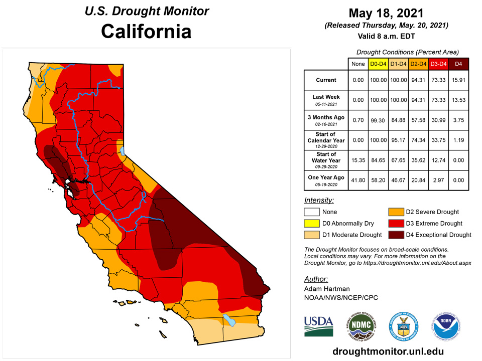
Most basin snow water equivalent (SWE) percentiles across the Western Region are well below normal for the period of record (near and below the 65th percentile), especially in the Four Corners region (below the 5th percentile in Arizona and New Mexico). Only parts of the Pacific Northwest and areas of central Montana experienced near and above-normal seasonal snowfall. However, above-normal temperatures over much of the West over the past 60 days has resulted in rapid snowmelt and, due to dry topsoil, much of the melt water has not made it into the rivers, lakes, and reservoirs. In California, the water level in Lake Tahoe is 2.5 feet lower than this time last year. USGS 7-day average stream flows across the coastal ranges near the Bay Area have dropped below the 2nd percentile. In addition, CPC soil moisture ranks below the 1st percentile, NASA GRACE indicates severely depleted groundwater, and vegetation indices (VegDRI and VHI) indicate severe vegetation stress. There are increasing reports of reduced pasture forage, livestock requiring supplemental feed and/or being sold off, and some reports of livestock mortality. Additionally, stock ponds are running dry and farmers have been forced to haul water in some locations. Given the worsening conditions, drought was deteriorated from D3 (extreme) to D4 (exceptional) in areas along the coastal ranges near the Bay Area. Targeted degradations were also made in portions of Idaho as a result of deteriorating soil moisture conditions (NASA SPoRT 0-10 cm and 0-40 cm depths and CPC soil moisture below the 5th percentile state-wide), supported by widespread D1-D3 30-90 day SPIs. New Mexico was the only state in the Western Region where improvements were warranted, as severe weather along the Front Range of the Rockies resulted in some small improvements in areas experiencing D3 and D4 drought conditions in northern and eastern parts of the state.
Caribbean
D1 (moderate drought) was expanded northeastward to southern Rio Grande County in Puerto Rico. This area has experienced less than 50 percent of normal precipitation in the last 30 days and USGS 7-day average stream flows have fallen below the 10th percentile.
The U.S. Virgin Islands remained dry for another week, with all three islands remaining at D2. The NWS’s quantitative precipitation estimates for the past 7 days indicated that none of St. Thomas or St. John received more than a quarter of an inch. St. Croix was similarly dry with the southwest part of the island receiving a quarter of an inch or less while the eastern tip remained dry.
Vegetation remained stressed across all islands. Precautions such as ordering hay and water deliveries were being taken to get through the dry season. Forests and grasslands were at risk for fire.
St. Thomas remained at D2-SL. Precipitation at Cyril E. King AP was 0.05 inches, or much below normal. The CoCoRaHS stations reported from 0.03 to 0.11 inches. The SPI values for the King Airport indicated drought-free conditions at 1, 3 and 12 months, moderate drought at 6 months, and abnormal dryness at 9 months. The Grade School 3 well was 14.752 feet below land surface and has not been so low since 2017.
St. John remained at D2-S. The Windswept Beach CoCoRaHS station reported 0.10 inches. Other CoCoRaHS stations reported from 0.10 to 0.44 inches. The SPI values for Windswept Beach indicated abnormal dryness at 1, 9 and 12 months, moderate drought at 3 months and severe drought at 6 months. The Susannaberg DPW 3 well was at 16.91 feet below land surface, the water level steadily falling since late 2020, when the water level was more than 7 feet below the land surface.
St. Croix remained at D2-SL. Precipitation at Henry Rohlsen AP amounted to 0.22 inches. The CoCoRaHS stations reported from 0.06 to 0.12 inches. The SPI values for Henry Rohlsen AP indicated moderate drought at 1, 3, 9 and 12 months and extreme drought at 6 months. The water level in Adventure 28 well was at 23.71 feet below land surface, the water at its lowest level since late 2016.
Pacific
Abnormal dryness (D0) continues for northern and eastern Mainland Alaska with no changes this week. Temperatures have verified above-normal over the past 30 days, but with near and above-normal snowpack across much of the state, no changes to the depiction were warranted this week
In Hawaii, persistent trade winds over the past couple of weeks have resulted in sufficient rainfall along the windward slopes and USGS stream flows to remain near-normal. USGS stream flows are mixed in the leeside streams of Oahu and NDVI supports a continued D0 depiction there as well. As such, no changes warranted this week in Hawaii.
The weather features across the U.S.-Affiliated Pacific Islands (USAPI) during this USDM week (05/12/21-05/18/21) included several surface troughs which migrated westward across Micronesia; trade-wind convergence associated with a developing Inter-Tropical Convergence Zone (ITCZ) over the Federated States of Micronesia (FSM) and Marshall Islands (RMI); weak circulations which developed over Yap State and Palau waters; and an old frontal boundary, with convergent trade-wind flow to its south, which lingered near the northern Marianas. One of the circulations developed into Tropical Depression 03W west of Palau. The surface convergence associated with these features was enhanced by divergence aloft associated with an upper-level trough and upper-level lows that stretched the length of Micronesia mainly north of 10 degrees North latitude. South of the equator, a high pressure ridge dominated the weather over the Samoan Islands, with scattered trade-wind showers bringing light rain to American Samoa.
Satellite-based estimates of 7-day precipitation (QPE) showed a band of precipitation stretching from Indonesia and the Philippines eastward across Micronesia and beyond, associated with the climatological ITCZ, and patchy areas of precipitation south of the equator bracketing the Samoan Islands. A continuous band of 1+ inches of rain ran from Palau, across the FSM, to the RMI, with embedded 4+ inch areas. Wisps of half an inch or less of rain were evident on the QPE over the Marianas. The Marianas showers were likely shallow and warm-topped, and precipitation from events like this is hard to detect by this satellite QPE tool. The QPE showed an area of 2+ inches of rain east of American Samoa, but little precipitation was detected over the Samoan Islands.
Rainfall for the Republic of Palau was above normal with Palau IAP receiving 5.45 inches and Koror COOP reporting 5.11 inches for the week. The area remained free of dryness.
The Mariana Islands remained at D0. Rainfall was above normal for Guam where 2.62 inches fell. The island was receiving frequent showers, greening the vegetation. Conditions were drier on Rota and Saipan. Rota received 0.99 inches, while Saipan received from 0.39 to 0.70 inches. Saipan was receiving just enough rain to turn vegetation green here and there.
The Federal States of Micronesia were mixed in terms of precipitation for the week, with some locations receiving less than the 2 inches needed for minimum weekly water needs. Ulithi has been dry, so D0 was introduced as rainfall was 0.51 inches, following three weeks of below normal precipitation. Kapingamarangi remained at D0 and received 1.36 inches. Rainfall was also below normal for Nukuoro, 0.59 inches; Pohnpei, 1.83 inches; and Yap with 1.40 inches. Chuuk and Fananu reported 4.01 and 6.78 inches, respectively.
The Marshall Islands were mostly wet for the week, apart from Ailinglaplap which received 0.50 inches, far below the weekly minimum of 2 inches to meet most water needs. All other locations all reported more than 2 inches for the week. Wotje remained at D2 and received 2.25 inches. Water was being rationed, and some crops were dying. Kwajalein continued at D1 and benefited from 2.74 inches of rain. Vegetation was recovering on Kwajalein island; on northern atolls, vegetation was not green or particularly lush. Residents of the northern Marshall Islands continue to conserve water, especially atolls with limited water resources and catchment tanks. Mili, Majuro and Jaluit received considerably more rain, reporting 6.90, 9.97, and 5.21 inches, respectively.
American Samoa was on the dry side for the past week, but remained free of dryness overall, as the previous week was wet, leaving the islands in good standing. Pago Pago received 0.77 inches, Siufaga Ridge reported 0.64 inches, and Toa Ridge received 0.38 inches.
Looking Ahead
During the next 5 days (May 20 to 24), the Southern and Central Plains, much of the Corn Belt, and Northern Tier states are favored to remain wet. Temperatures are also forecast to remain below-normal for much of the period across the Northern Tier. High pressure is expected to dominate over the eastern U.S., coinciding with little to no rainfall and above-normal temperatures. The Southwest and Coastal California will likely remain dry also. However, temperatures are favored to remain below-normal, moderating to near-normal as the week progresses toward Tuesday.
The CPC 6-10 day extended range outlook (valid from May 25 to 29) favors above normal temperatures across the eastern U.S. and Central and Southern Plains, with enhanced probabilities in the Southeast. Above normal temperatures are also favored over northern and western Mainland Alaska, with above-normal probabilities extending to the eastern Aleutians. Below-normal temperatures are favored from the Pacific Northwest eastward to the Dakotas. Above-normal precipitation is predicted across the Southern and Central Plains, Corn Belt, and Lower Great Lakes. In Alaska, odds tilt toward above-normal precipitation for the Southwest Mainland, Eastern Aleutians, and along the South Coast to the Northwest Panhandle. Below-normal precipitation is favored in the Southeast U.S. and along the East Coast, with enhanced probabilities in the Deep South and Florida. Below-normal precipitation is also favored for the Central Pacific Coast, Great Basin, and Eastern Rockies to the High Plains.
Author(s):
Adam Hartman, NOAA/NWS/NCEP/CPC
Denise Gutzmer, National Drought Mitigation Center
Dryness Categories
D0 Abnormally Dry—used for areas showing dryness but not yet in drought, or for areas recovering from drought.
Drought Intensity Categories
D1 Moderate Drought
D2 Severe Drought
D3 Extreme Drought
D4 Exceptional Drought
Drought or Dryness Types
S Short-term, typically less than 6 months (agriculture, grasslands)
L Long-term, typically more than 6 months (hydrology, ecology)
SL Area contains both short- and long-term impacts
Source: National Drought Mitigation Center
