


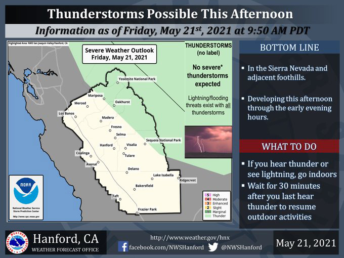
Includes Eastern Mariposa and Madera Counties and Yosemite National Park
May 21, 2021 - The National Weather Service Hanford Office reports a few thunderstorms are possible along the Sierra Nevada and foothills starting late this morning through the afternoon and evening hours.
Small hail and wind gusts near 40 miles per hour are a couple of hazards associated with strong thunderstorms.
In addition to dangerous cloud to ground lightning strikes, any thunderstorm can produce intense rainfall rates, leading to localized flooding.
  Area Forecast Discussion
  National Weather Service Hanford CA
  355 AM PDT Fri May 21 2021

  .SYNOPSIS...Unseasonably cool weather will continue over the
  district through Saturday with scattered showers and isolated
  thunderstorms over the Sierra during the afternoon and early
  evening hours both days. Dry weather can be expected Sunday
  through the end of next week. Temperatures will recover to
  seasonable levels Sunday. Much of next week will average
  slightly warmer than normal.

  &&

  .DISCUSSION...Another exceptionally cool day is on tap for the
  central California interior, but at least it will not be as
  windy as Thursday. Although northwesterly breezes may still gust
  to about 25 mph on the west side of the San Joaquin Valley this
  afternoon and westerly winds could gust up to 40 mph through and
  below the Kern county mountain passes, wind speeds will remain
  below advisory levels in most locations. Otherwise, afternoon
  temperatures today will average a good ten degrees below normal.

  The storm system that brought this unseasonably cool air mass into
  the district is currently centered over Mono County. Although it
  is limited on moisture, it will produce showers over the Sierra
  today, primarily from midday into this evening. A few showers may
  also pop up over the coastal ranges west of I-5 this afternoon as
  well. By late this afternoon, a few showers will probably develop
  over the Sierra foothills, and as they wander toward the east side
  of the San Joaquin Valley, most will probably evaporate as they
  come into an otherwise very dry air mass that resides over the San
  Joaquin valley. Nonetheless, some sprinkles could fall out of
  these otherwise ominous looking clouds in the eastern third of the
  valley very late this afternoon or this evening. It will be cold
  enough for precipitation to fall as snow showers above 5500 feet
  today and it`s possible that a few inches could accumulate above
  this elevation in some locations by this evening. Backpackers and
  hikers in the Sierra high country should be prepared for wintry
  weather this afternoon and evening. In addition, a few showers may
  be accompanied by some thunder, lightning and small hail over the
  Sierra this afternoon into early this evening.

  By later this evening, the storm system will drift into the Great
  Basin where it will sit nearly idle through Saturday as a strong
  anticyclone over the Eastern U.S. slows its eastward movement this
  weekend. That being said, Saturday could bring a recurrence of
  mainly afternoon showers and higher elevation snow showers over
  the Sierra. Otherwise, a cool northerly flow aloft will reside
  over central California through the first half of this weekend.
  Although the air mass over the CWA modifies somewhat on Saturday,
  high temperatures will still run several degrees below normal.

  Sunday looks like the best day, weatherwise, this weekend, with
  mostly sunny skies. Despite another chilly start to the day,
  temperatures should finally rebound to seasonable levels Sunday
  afternoon. A weak upper level ridge will move over central
  California Monday and bring further warming. Thermometer readings
  will flirt with the 90 degree mark in many locations of the San
  Joaquin Valley, lower foothills and the Kern County desert Monday
  afternoon. The ensembles bring a short wave trough through the
  Pacific Northwest early next week which in turn will flatten the
  upper level ridge over central California and probably trim high
  temperatures a bit on Tuesday and Wednesday.

  The models become polarized in their solutions on days 6 and 7.
  Some of them forecast weak ridging aloft over central California
  while other ensemble members forecast a weak upper level trough
  to reside over the Golden State. Confidence in temperature trends
  during this period is medium at best, so we`re opting for a middle
  of the road solution and keeping high temperatures slightly above
  normal later next week. Otherwise, dry weather will be the rule.
Source: NWS

