


Includes Eastern Madera and Mariposa Counties and Yosemite National Park
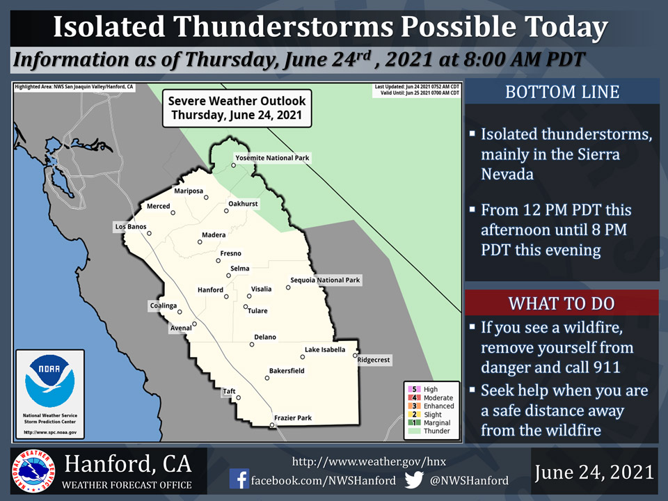
June 24, 2021 - The National Weather Service Hanford Office reports isolated thunderstorms are possible in the Sierra Nevada, mainly over the higher elevations, during this afternoon and evening.
Gusty erratic winds, brief heavy rainfall, and dangerous lightning are expected with any thunderstorms although it is possible some thunderstorms may produce little or no precipitation at the surface.
  Area Forecast Discussion
  National Weather Service Hanford CA
  323 AM PDT Thu Jun 24 2021

  .SYNOPSIS...Temperatures will average close to normal over the
  area through Friday. There is a slight chance of afternoon and
  evening thunderstorms over the Sierra Nevada today and Friday.
  Above normal temperatures will return this weekend and continue
  through next week with a return of isolated thunderstorms to the
  region.

  &&

  .DISCUSSION...
  Closed upper level low off the CENCAL coast is remaining nearly
  stationary. Onshore flow continues through the Delta and into the
  San Joaquin Valley with near normal temperatures expected today
  and tomorrow. Valley temps will once again get back into the
  triple digits and stay there through the upcoming week. We are
  expecting a few showers and a possible thunderstorm this afternoon
  and evening across the Sierra north of Kings Canyon.

  Models are in decent agreement with the track of the upper level
  low center moving inland and dissipating over CENCAL as an upper
  level high pressure center rapidly develops across the PAC NW on
  Friday. The ridge will take over the pattern across our area. A
  secondary low center will move to about the same location as the
  current low center by Sunday night. This is where we will see the
  Delta breezes kick in across Merced, Mariposa and by Monday...
  Madera counties. This will lower temperatures north of Fresno
  county in the valley and provide some relief as temps may drop
  below the century mark on Monday. The cooler air will be confined
  to the mainly the eastern side of the SJV through Thursday as the
  low remains nearly stationary through Monday before lifting
  northeast towards the NORCAL coast. This will also play a role in
  possible diurnal convection across the SJV and the Sierra on
  Tuesday and continue through Thursday as easterly flow will bring
  sub-tropical moisture into CENCAL. We will continue to monitor the
  thunderstorm potential for next week as the mid and upper level
  flow will become favorable to bring in mid level moisture to the
  region.

  &&

  .AVIATION...Areas of MVFR ceiling with local mountain obscuring
  IFR in showers and thunderstorms over the Sierra Nevada from
  Fresno County northward 18Z Thu through 03Z Friday. Otherwise,
  VFR conditions will prevail throughout the central CA interior for
  at least the next 24 hours.
Source: NWS
