


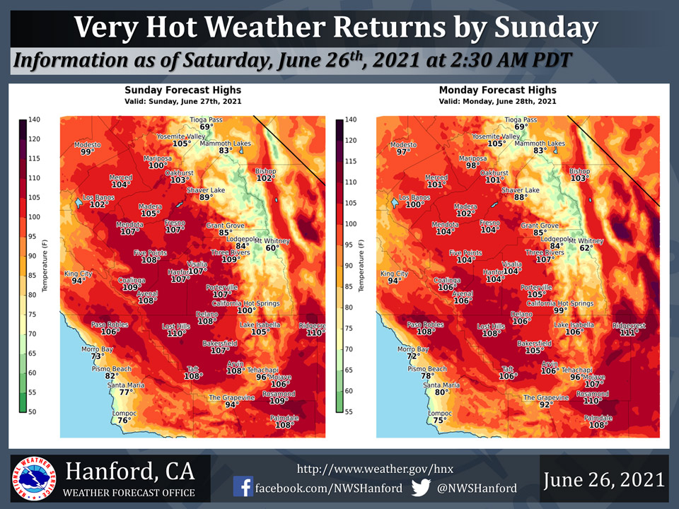
Mariposa projected high temperature for Sunday: 100 degrees, Monday: 98 degrees
Oakhurst projected high temperature for Sunday: 103 degrees, Monday: 101 degrees
Yosemite Valley projected high temperature for Sunday: 105 degrees, Monday: 105 degrees
June 26, 2021 - The National Weather Service Hanford Office reports a warming trend will begin with high temperatures throughout Central California returning to several degrees above average.
Very hot weather returns to much of Central California starting on Sunday. Expect daytime highs to reach around 10 to 15 degrees above average for Sunday through at least next Wednesday with little day to day change expected, and overnight lows may also be quite warm in some locations, such as urban areas.
Drink plenty of fluids, wear loose fitting clothing, and limit outdoor activity during peak daytime heating hours, or starting around 10 AM.
Never leave children or pets unattended in vehicles.
  Area Forecast Discussion
  National Weather Service Hanford CA
  315 AM PDT Sat Jun 26 2021


  .SYNOPSIS...A warming trend will continue over the weekend
  resulting in well above normal temperatures through next week.
  An Excessive Heat Warning is in effect for much of the lower
  elevations on Monday and Tuesday. Scattered showers and isolated
  thunderstorms are possible over much of the region beginning
  Monday and continuing through the week.

  &&

  .DISCUSSION...
  Satellite loops showing clear skies across the central California
  interior tonight. A modest onshore surface flow is evident looking
  at the SFO-LAS surface pressure around 8 mb. This has winds gusting
  up to 35 mph through the Kern County mountain passes. Otherwise,
  the upper low that was spinning off the central coast for a few
  days has now weakened and shifted inland as an upper ridge begins
  building over the west coast. Temperatures warmed slightly Friday
  with highs right around climatological normals for late June.

  The amplified upper ridge which extends all the way up into British
  Columbia, will bring further warming through the weekend. Expecting
  widespread triple digit heat to develop across the lower elevations
  this afternoon. By Sunday, high temperatures are forecast to climb
  to as much as 15 degrees above normal in some lower elevation areas.
  Temperatures look to nudge down a couple of degrees on Monday. An
  Excessive Heat Warning is in effect for the Kern County Desert, the
  West Side Hills, and for much of the San Joaquin Valley on Sunday
  and Monday. The latest NBM probabilistic guidance is giving Fresno
  a 52% chance of reaching at least 105 degrees on Sunday, and gives
  Bakersfield a 50% chance. While this does not look to be quite as
  hot as the heat wave a week ago, it will create a dangerous heat
  risk. Also, the triple digit heat is expected to continue
  throughout the week and into next weekend.

  Models are continuing to advect moisture into the region from the
  east and south beginning on Monday. A slight chance of afternoon
  and evening showers and thunderstorms is painted across the Sierra
  Nevada on Monday. The moisture is fairly shallow initially and not
  much rainfall is likely on Monday. By Tuesday, the moisture becomes
  deeper and more widespread, extending precip chances down into the
  Kern County mountains and desert and also the eastern and southern
  ends of the San Joaquin Valley. Chances continue through the week
  as an easterly wave may bring an additional surge of moisture.

  &&

  .AVIATION...VFR conditions will prevail throughout the central CA
  interior for at least the next 24 hours.

  &&

  .AIR QUALITY ISSUES...
  On Saturday June 26 2021...Unhealthy for sensitive groups in Kern
  and Tulare Counties and Sequoia National Park and Forest. Further
  information is available at Valleyair.org
Source: NWS
