


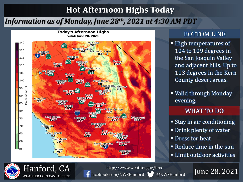
Mariposa projected high temperature for Monday: 98 degrees
Oakhurst projected high temperature for Monday: 101 degrees
Yosemite Valley projected high temperature for Monday: 106 degrees
June 28, 2021 - The National Weather Service Hanford Office reports an Excessive Heat Warning is in effect from this afternoon until Monday evening for portions of the San Joaquin Valley, West Side Hills, and the Kern County desert areas.
Counties included in the warned area include: Fresno, Kings, Tulare, and Kern Counties.
High temperatures will be 104 to 109 degrees in the San Joaquin Valley and West Side Hills.
Very hot temperatures, including highs 108 to 113 degrees, are likely in the Kern County desert areas.
Heat related illnesses, such as heat exhaustion and heat stroke will be possible.
Drink plenty of fluids, stay out of the sun, and remain in an air-conditioned room.
In addition, warm overnight and morning temperatures are expected, with lows in the 70s to the lower 80s.
  Area Forecast Discussion
  National Weather Service Hanford CA
  328 AM PDT Mon Jun 28 2021


  .SYNOPSIS...
  Hot temperatures will continue through the week, with dangerous
  heat expected again this afternoon. Isolated to scattered showers
  and thunderstorms are possible over the Sierra Nevada today and
  spreading over much of the region for the remainder of the week.

  &&

  .DISCUSSION...
  Strong, amplified ridging continues over the far west with the
  main high centered over the British Columbia/Washington border.
  Very hot temperatures were observed throughout lower elevations
  with afternoon highs well into the triple digits. Many areas had
  highs around 12 degrees above climatological normals for the end
  of June. While there were no record high temperatures set across
  the San Joaquin Valley on Sunday, Fresno did set a new record high
  minimum temperature of 79 degrees for June 27th, and Bakersfield
  tied the record high minimum temperatures of 80 degrees. The heat
  will change little today and the Excessive Heat Warning remains in
  effect until 8 PM this evening. The Heat Warning may be extended
  into Tuesday but there is some potential for cloud cover from the
  east that could hold temperatures down a few degrees.

  The cloud cover referenced would be due to mid-level sub tropical
  moisture that will be increasing over the net couple of days. Hi-
  resolution modeling shows fairly isolated convection popping over
  the Sierra Nevada this afternoon. But the lower atmosphere remains
  dry, thus little if any rainfall is expected with any thunderstorm
  that develop this afternoon. This in combination with the very dry
  fuels will create an increased threat of wildfire starts from dry
  lightning. A Red Flag Warning is in effect for the Sierra Nevada
  beginning this afternoon. While the moisture increases in coverage
  on Tuesday, spreading the thunderstorm threat down into Kern County
  and even into the eastern side of the SJ Valley, the lower levels
  of the atmosphere may take longer to moisten up. Therefore, the
  Red Flag Warning will remain in effect for the Sierra through 8 PM
  Tuesday. Also, the Lake Isabella and Tehachapi zones go under the
  Red Flag Warning on Tuesday from 1 PM until 8 PM. RH progs suggest
  the storms should turn wet after Tuesday. There could even be some
  nocturnal convection Tuesday night into Wednesday morning. Showers
  and thunderstorms possible across the same areas on Wednesday then
  a gradual decrease in moisture will reduce the threat to just the
  Sierra by Friday. Drier southwest flow aloft develops next weekend.
  Temperatures will remain several degrees above normal from midweek
  on with much of the SJ Valley seeing highs around the century mark.

  &&

  .AVIATION...
  Local MVFR/IFR due to isolated thunderstorms possible over the
  Sierra Nevada from 18z today until 04z Tuesday. Otherwise, VFR
  conditions will prevail throughout the central CA interior for at
  least the next 24 hours.

  &&

  .AIR QUALITY ISSUES...
  On Monday June 28 2021...Unhealthy for sensitive groups in
  Fresno...Kern and Tulare Counties and Sequoia National Park and
  Forest. Further information is available at Valleyair.org
Source: NWS
