


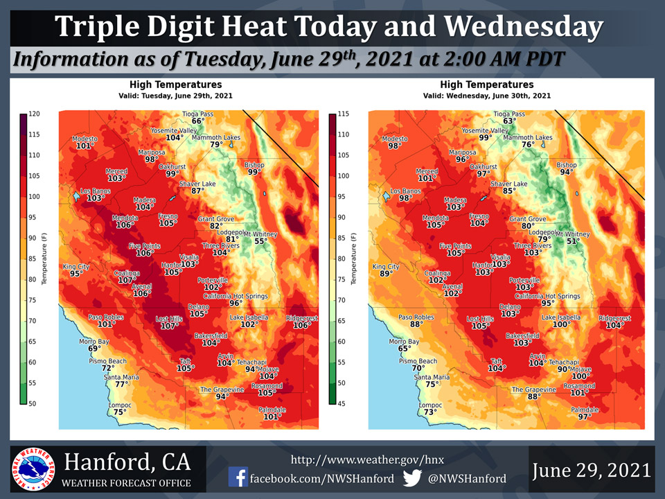
Mariposa projected high temperature for Tuesday: 98 degrees, Wednesday: 96 Degrees
Oakhurst projected high temperature for Tuesday: 99 degrees, Wednesday: 97 Degrees
Yosemite Valley projected high temperature for Tuesday: 104 degrees, Wednesday: 99 Degrees
June 29, 2021 - The National Weather Service Hanford Office reports widespread triple digit heat is expected in the San Joaquin Valley, Coastal Range, and Kern County desert this afternoon and Wednesday afternoon.Limit outdoor activities, reduce time in the sun, and drink plenty of water.
As always, never, ever leave a child or pet in an enclosed automobile.
  Area Forecast Discussion
  National Weather Service Hanford CA
  302 AM PDT Tue Jun 29 2021


  .SYNOPSIS...
  Hot temperatures will continue through the week, with dangerous
  heat expected again this afternoon. Isolated to scattered showers
  and thunderstorms are expected over the mountains and desert today
  and Wednesday, with a small chance a storm could drift over the
  east side or south end of the San Joaquin Valley. Isolated storms
  continue over the Sierra Nevada each afternoon through the end of
  the week.

  &&

  .DISCUSSION...
  Amplified ridge remains in control over the west with the strong
  high centered slightly eastward from yesterday over the British
  Columbia/Washington border. High temperatures on Monday were a
  little lower than forecast, partly due to cirrus clouds spreading
  downstream from from Sierra convection. While there is potential
  for the same occurrence today, afternoon highs across the lower
  elevations could reach 102-107 degrees, creating a high risk for
  heat related illness. Therefore, an Excessive Heat Warning is in
  effect today across the Kern County Desert, the San Joaquin Valley
  from Fresno County southward, and the adjacent West Side Hills.
  The upper ridge will gradually shift east the next few days with
  the center of the high becoming established over the more typical
  Four Corners region by this weekend. Temperatures will trend a
  little lower with afternoon highs generally around 4 to 8 degrees
  above climo. Afternoon highs in the SJ Valley later this week and
  weekend are generally expected to top out around the century mark.

  The other weather concern is the potential for thunderstorms over
  the next several days. Mid-level moisture continues to stream in
  from the east and high resolution models are showing an increase
  in mountain convection over yesterday. But the potential for dry
  lightning is still there as it may take another day for the lower
  atmosphere to moisten up. A Red Flag Warning for dry thunderstorms
  and gusty outflow winds is in effect for the Sierra Nevada and the
  Kern County Mountains today. It`s even possible a thunderstorm
  could drift over the east side or south end of the valley today.
  Also, cannot rule out a little nocturnal convection tonight into
  Wednesday morning. Similar coverage is expected on Wednesday but
  there are some signs of some drier air trying to push in from the
  coast. Moisture decreases after Wednesday with the thunderstorm
  threat trimming back to just the Sierra Thursday through Saturday.


  &&

  .AVIATION...
  Local MVFR/IFR over the mountains due to isolated thunderstorms
  after 18Z Tuesday. Otherwise, VFR conditions will prevail across
  the central CA interior for at least the next 24 hours.

  &&

  .AIR QUALITY ISSUES...
  On Tuesday June 29 2021...Unhealthy for sensitive groups in Kern
  County and Sequoia National Park and Forest. Further information
  is available at Valleyair.org
Source: NWS
