


Includes Yosemite National Park and Oakhurst
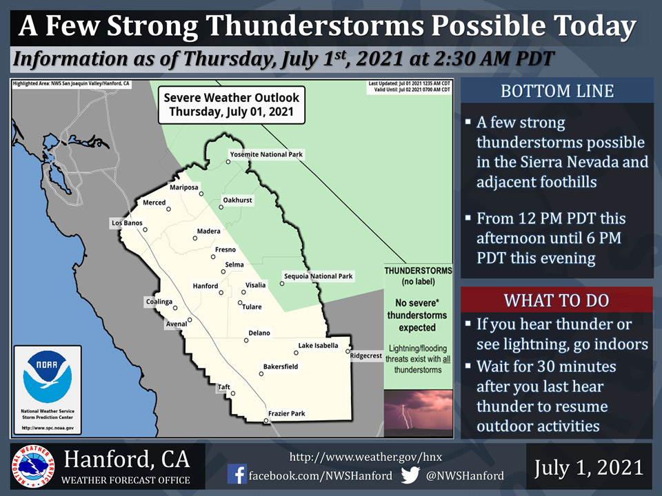
July 1, 2021 - The National Weather Service Hanford Office reports a few strong thunderstorms are possible in the Sierra Nevada and adjacent foothills this afternoon into this evening. Dangerous cloud to ground lightning strikes, localized flooding, small hail, and wind gusts near 45 mph are hazards associated with strong thunderstorms.
  Area Forecast Discussion
  National Weather Service Hanford CA
  305 AM PDT Thu Jul 1 2021


  .SYNOPSIS...
  High temperatures will be around the century mark in San Joaquin
  Valley Thursday into early next week. Moisture aloft will continue
  to allow for a chance of thunderstorms over the Sierra Thursday
  however a turn to a more southwest flow on Friday and Saturday
  will diminish the threat.

  &&

  .DISCUSSION...
  After another active day of convection across the Sierra Nevada,
  local radar is free of echoes and satellite imagery showing just
  some residual clouds now. Elsewhere, temperatures climbed to well
  above normal again with widespread triple digit highs across the
  San Joaquin Valley, Sierra Foothills, and Kern County Desert. A
  couple high temepratures of note were 108 degrees at Three Rivers
  and Taft, and 107 degrees at Lemoore.

  The strong ridge of high pressure responsible for the heat wave
  over the last several days is weakening a little and shifting east.
  Temperatures are forecast to lower slightly today but will remain
  several degrees above normal. Most of the SJ Valley is expected to
  top out around the century mark today. But a little onshore flow
  should hold parts of Merced and Madera County in the mid to upper
  90s. The National Blend of Models shows little changes in temps
  from today through the weekend.

  With monsoon moisture in place, daytime heating will trigger another
  round of afternoon showers and thunderstorms over the Sierra Nevada.
  Some drier air in southwest flow aloft will keep convection north
  of Kern County with the thunderstorm threat mainly from Yosemite NP
  to Sequoia NP. Light steering flow will cause slow moving storms and
  the potential for localized heavy rainfall to occur. Further drying
  of the airmass from the south will occur on Friday. A few showers
  and thunderstorms will remain possible around Yosemite NP on Friday
  afternoon. Models are showing a little surge of mid- level moisture
  from the south on Saturday for a possible uptick in the coverage of
  convection across the Sierra. That moisture dwindles on Sunday for
  one more day of Sierra convection.

  Model ensembles agree with a high pressure cell developing over the
  climatologically favored Four Corners region early next week. This
  high may strengthen and build westward over southern California by
  midweek for another warming trend towards well above normal temps.

  &&

  .AVIATION...
  VFR conditions will prevail throughout Central California this
  morning. MVFR/IFR conditions in and near scattered showers and
  thunderstorms over the Sierra Nevada and adjacent foothills from
  19z this afternoon until 03z this evening.

  &&

  .AIR QUALITY ISSUES...
  On Thursday July 1 2021...Unhealthy for sensitive groups in Kern
  and Tulare Counties and Sequoia National Park and Forest. Further
  information is available at Valleyair.org
Source: NWS
