


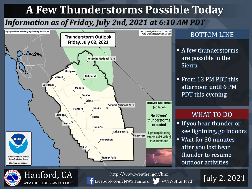
Includes Yosemite National Park and Oakhurst
July 2, 2021 - The National Weather Service Hanford Office reports a few thunderstorms are possible in the Sierra Nevada and adjacent foothills this afternoon into this evening. Small hail and wind gusts near 45 miles per hour are a couple of hazards associated with these thunderstorms.
In addition to dangerous cloud to ground lightning strikes, any thunderstorm can produce intense rainfall rates, leading to localized flooding.
  Area Forecast Discussion
  National Weather Service Hanford CA
  345 AM PDT Fri Jul 2 2021


  .SYNOPSIS...
  High temperatures will hover right around the century mark in the
  San Joaquin Valley into early next week. Drier air will diminish
  the chances of Sierra thunderstorms to around Yosemite NP this
  afternoon. But a quick shot of moisture will bring another chance
  for most of the Sierra on Saturday. Drier air Sunday through
  Tuesday will bring little to no threat of thunderstorms anywhere
  in the Central California Interior.

  &&

  .DISCUSSION...
  Satellite loops are showing mainly clear skies across the central
  California interior early this morning. Thunderstorm activity was
  more limited on Thursday, with most of the activity confined to
  right along the Sierra crest from Yosemite NP to Kings Canyon NP.
  Drier air continues to push in from the south and will limit the
  threat even further today to mainly around Yosemite NP during the
  afternoon. Models are still showing a surge of moisture from the
  south on Saturday. This will expand the thunderstorm threat from
  Yosemite NP south to Sequoia NP. The threat retreats a bit farther
  north on Sunday with the slight chance of afternoon thunderstorms
  from Yosemite NP to Kings Canyon NP. The air mass looks to dry out
  enough on Monday to end the thunderstorm threat. Models show a few
  pushes of moisture next week around a Four Corners high pressure
  cell. This moisture looks rather shallow and may only provide for
  some mid/high level clouds at times next week.

  Temperatures will change little from yesterday with highs mainly a
  few degrees above normal for early July. Most of the San Joaquin
  Valley will top out around the century mark though cooler marine
  air will help keep parts of Merced and Madera Counties in the 90s.
  Persistence looks to prevail through the weekend and into at least
  the middle of next week as the Four Corners high dominates. Slight
  warming is forecast next Thursday and Friday. Signs are pointing to
  another heat wave as model ensembles build the high pressure dome
  westward over California as a 600 DM high by the following weekend.

  &&

  .AVIATION...
  MVFR/IFR conditions in and near showers and thunderstorms around
  Yosemite NP from 19z this afternoon until 02z this evening. VFR
  conditions will prevail elsewhere throughout Central California
  for the next 24 hours.

  &&

  .AIR QUALITY ISSUES...
  On Friday July 2 2021...Unhealthy for sensitive groups in Kern
  and Tulare Counties and Sequoia National Park and Forest. Further
  information is available at Valleyair.org
Source: NWS
