


Includes Yosemite National Park
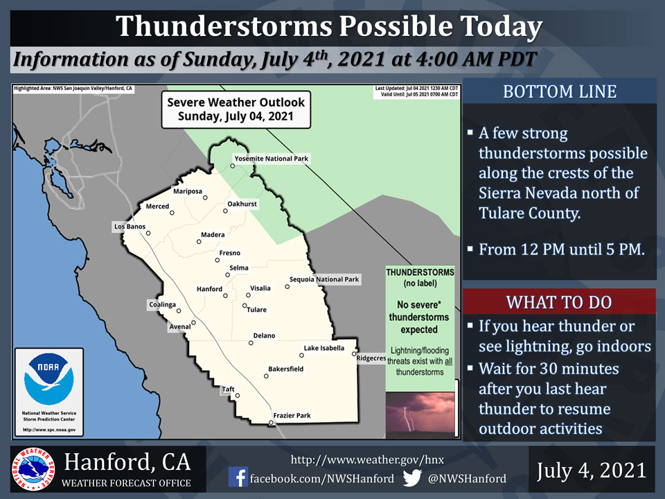
July 4, 2021 - The National Weather Service Hanford Office reports a few strong thunderstorms are possible along the crests of the Sierra Nevada north of Tulare County this afternoon. Small hail and wind gusts near 45 miles per hour are a couple of hazards associated with strong thunderstorms.
In addition to dangerous cloud to ground lightning strikes, any thunderstorm can produce intense rainfall rates, leading to localized flooding.
  Area Forecast Discussion
  National Weather Service Hanford CA
  333 AM PDT Sun Jul 4 2021


  .SYNOPSIS...
  Isolated thunderstorms will be possible over the Sierra Nevada
  crest around Yosemite NP this afternoon. Otherwise dry and warm
  weather is expected, with temperatures running a few degrees above
  normal through the middle of the week. Temperatures will trend
  much warmer later in the week into next weekend, increasing the
  risk of heat related illnesses.

  &&

  .DISCUSSION...
  Satellite loops show mainly clear skies across central California
  early this morning. A push of moisture from the south kicked off
  a few thunderstorms along the Sierra Nevada high country yesterday
  afternoon, from Yosemite NP to Kings Canyon NP. A drier southwest
  flow aloft will limit the thunderstorm today to right along the
  crest from Yosemite NP to Devils Postpile. Elsewhere, sunny skies
  will prevail this 4th of July with high temperatures a few degrees
  above normal for this time of the year. The San Joaquin Valley is
  expected to see most areas top out around the century mark, though
  a little marine air will keep areas from around Los Banos to Merced
  to Madera in the mid to upper 90s again. The Kern Desert will see
  max temps of 100-105 degrees today, while the Indian Wells Valley
  remains the hot spot with highs up to 108 degrees this afternoon.

  High pressure will remain over the Four Corners region through the
  middle of the week. Temperatures will change little from day to day
  with highs generally a few degrees above normal. Models show little
  moisture until Wednesday but even that looks fairly shallow and may
  only provide a few mid/high level clouds. Model ensembles agree in
  building the ridge westward over Nevada/California next weekend. A
  600 decameter H5 high is projected which would mean a warming trend
  to well above normal temperatures. Excessive heat could affect the
  Desert later this week and then the San Joaquin Valley, the lower
  foothills, and the mountain valleys by next weekend. In fact, there
  is potential for significant heat related impacts by next weekend if
  this pans out. The NBM (National Blend of Models) gives China Lake
  a 58% chance of reaching 115 degrees or higher on Saturday, July 10.
  It`s giving Fresno a 32% chance of reaching at least 110 degrees on
  Sunday, July 11.

  &&

  .AVIATION...
  MVFR/IFR conditions possible in and near isolated thunderstorms
  along the Sierra crest near Yosemite NP from 19z Sun until 02z Mon.
  VFR conditions will prevail elsewhere throughout Central California
  for the next 24 hours.

  &&

  .AIR QUALITY ISSUES...
  On Sunday July 4 2021...Unhealthy for sensitive groups in Sequoia
  National Park and Forest. Further information is available at
  Valleyair.org
Source: NWS
