


July 10, 2021 - Yosemite National Park officials report on Monday, June 28, 2021, through July 2, thunderstorms developed over Yosemite National Park, creating lightning that ignited 19 fires. Fire managers have been assessing all fires for an appropriate response. Due to the risk of visitor safety and park values, the King Fire has been suppressed in the Illilouette Creek drainage, and five fires, Harden, Pothole, Ridge, Coyote and Kerrick are out. The Fork Fire east of Mt. Starr King, has been contained at 12 acres. Remaining fires are burning in high elevation areas located in wilderness ranging from 7,000 to 9,700 feet. One additional fire, North, was reported on July 8 and is an escaped campfire; this fire has been suppressed. The weather is forecast to be hot and dry through this weekend, with record temperatures potential scattered thunderstorms.
Yosemite National Park is a fire-adapted ecosystem. The overall strategy for managing all wildland fires is to provide for the safety of employees and the public and protect and enhance natural and cultural resources.
King
Location: South of Nevada Falls, north of Mount Starr King. 7220 elevation.
Discovery Date: June 29, 2021 Size: 10 acres
Containment: 100% Strategy: Suppression
Cause: Lightning
Quartzite
Location: West of Quartzsite Peak. 8781 elevation.
Discovery Date: June 29, 2021 Size: .5 acre
Containment: 0% Strategy: Monitor
Cause: Lightning
Harden
Location: North of Harden Lake, south of Hetch Hetchy. 6665 feet elevation.
Discovery Date: July 1, 2021 Size: .25 acre
Containment: Out 7/4/2021 Strategy: Suppression
Cause: Lightning
Stubblefield
Location: Northern end of Yosemite NP, near Stubblefield and Kerrick canyons. 8000 elevation.
Discovery Date: June 28, 2021 Size: .1 acre
Containment: 0% Strategy: Monitor
Cause: Lightning
Porcupine
Location: Northeast of Porcupine Campground, and Tioga Road. 8210 elevation.
Discovery Date: June 28, 2021 Size: 1. acres
Containment: 0% Strategy: Monitor
Cause: Lightning
Coyote
Location: Coyote Rocks, north of Tioga Road. 9742 elevation.
Discovery Date: June 28, 2021 Size: .1 acre
Containment: Natural Out. Strategy: Monitor
Cause: Lightning
Hidden
Location: Northwest of Olmsted Point, Tioga Road. 9017 elevation.
Discovery Date: June 28, 2021 Size: .1 acre
Containment: 0% Strategy: Monitor
Cause: Lightning
County Line
Location: Near Yosemite Creek Campground Road. 8361 elevation.
Discovery Date: June 28, 2021 Size: .6 acres
Containment: 0% Strategy: Monitor
Cause: Lightning
Lukens
Location: West of Lukens Lake, North of Tioga Road. 8243 elevation.
Discovery Date: June 28, 2021 Size: 1.4 acre
Containment: 0% Strategy: Monitor
Cause: Lightning
Wegner
Location: East of Yosemite Creek Picnic Area and east of Tioga Road. 8256 elevation.
Discovery Date: June 28, 2021 Size: .25 acre
Containment: 0% Strategy: Monitor
Cause: Lightning
Half Moon
Location: West of Ten Lakes near Half Moon Meadow. 8256 elevation.
Discovery Date: June 28, 2021 Size: .1 acre
Containment: 0% Strategy: Monitor
Cause: Lightning
Pothole
Location: South of Glacier Point Road. 7885 elevation.
Discovery Date: June 28, 2021 Size: .1 acre
Containment: Out Strategy: Suppressed
Cause: Lightning
Fork
Location: 1 mile southeast of Mt. Starr King. 8500 elevation.
Discovery Date: June 28, 2021 Size: 12 acres
Containment: 100% Strategy: Confine and Contain
Cause: Lightning
Ridge
Location: South of Glacier Point Road, across from Sentinel Parking area. 8000 elevation.
Discovery Date: July 3, 2021 Size: .10 acre
Containment: Out 7/4/2021 Strategy: Confine and Contain
Cause: Lightning
Lake
Location: West slope of Mt Hoffman. 9000 elevation.
Discovery Date: July 3, 2021 Size: .10 acre
Containment: Natural Out. Strategy: Confine and Contain
Cause: Lightning
Lost
Location: Northeast Starr King Meadow. 8700 elevation.
Discovery Date: July 6, 2021 Size: .25 acre
Containment: 100% Strategy: Suppression
Cause: Lightning
North
Location: North side of North Dome.
Discovery Date: July 8, 2021 Size: .10 acre
Containment: 100% Strategy: Suppression
Cause: Escaped campfire
For the most up-to-date fire information follow Inciweb: https://inciweb.nwcg.gov/
Yosemite Fire 7.10.2021 Updates Printable PDF
Yosemite Fire Map 7.10.2021 Printable PDF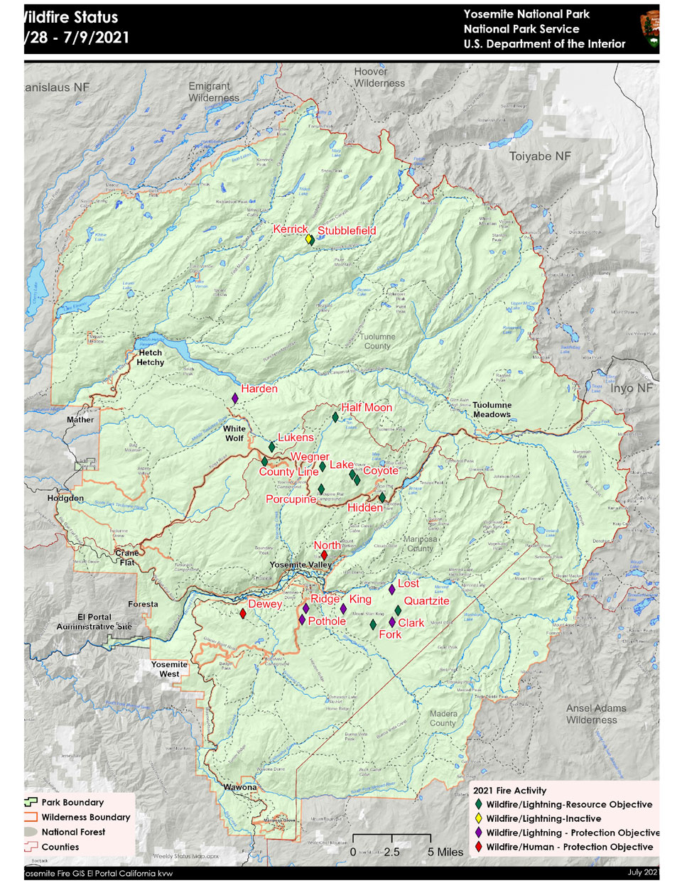
-
Air Quality: Yosemite Air Quality Page or airnow.gov or airnow.gov/fires
-
Trail Closures: https://www.nps.gov/yose/planyourvisit/conditions.htm
-
Fire Restrictions: https://www.nps.gov/yose/planyourvisit/firerestrictions.htm
-
National Weather Service Yosemite area forecast: www.weather.gov/hanford
-
Sign-up for Alerts: go.nps.gov/alert
-
Yosemite National Park Fire Information webpage: go.nps.gov/yosefire
-
Facebook: @YosemiteFire
-
Twitter: @YosemiteFire
Source: NPS
