


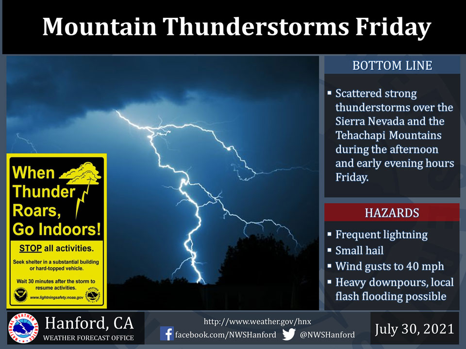
July 30, 2021 - The National Weather Service Hanford Office reports scattered thunderstorms will develop over the mountains this afternoon and linger into the evening hours.
In addition to dangerous cloud to ground lightning, a few thunderstorms will bring small hail, wind gusts to about 40 mph and heavy rainfall with the potential for flash flooding.
Hikers should be prepared to seek a safe place when skies turn ominous and thunder is heard.
  Area Forecast Discussion
  National Weather Service Hanford CA
  229 AM PDT Fri Jul 30 2021


  .SYNOPSIS...
  Slightly warmer than average high temperatures look likely into
  the foreseeable future over the forecast area. Monsoonal moisture
  will provide the Sierra Nevada with a chance of afternoon and
  evening thunderstorms each day until Sunday.

  &&

  .DISCUSSION...Latest radar images show a few remnant showers over
  the Sierra Nevada. Otherwise, expect a warm and muggy morning with
  mid-level cloud cover throughout Central California with yet
  another warmer than average afternoon today. Additional showers
  and thunderstorms are expected to develop by this afternoon in the
  mountains and desert, so these areas may not be quite as warm as
  on Thursday. There is even a slight chance for showers with
  afternoon and evening thunderstorms along the east side of the San
  Joaquin Valley from today until Saturday. The upper-level ridge
  over the Plains and much of the Western U.S. combined with the
  offshore trough will continue to bring a south to southeast flow
  carrying additional subtropical moisture along with embedded
  impulses. We will keep the Flash Flood Watch in effect until
  Saturday evening for the mountain areas from Yosemite to the
  Tehachapi Mountains as these areas will be most favorable for
  storms that produce heavy rainfall. Also, the precipitable water
  will be sufficient for scattered thunderstorms to produce heavy
  rainfall in these areas during today and Saturday.

  By Sunday, expect a decrease in storm coverage, or mainly over the
  Sierra Nevada. The monsoonal moisture will begin to shift
  northeastward, as the flow aloft turns more southwesterly while
  the upper-level trough approaches the coast of Northern CA.
  Afterward, a drying trend is likely for much of next week.
  However, we will likely see little relief over the next several
  days from triple digit temperatures in the warmest areas,
  including in the San Joaquin Valley and Kern County desert areas.
  The only exception is some locations in the Central Valley and
  Kern County desert may not quite reach 100 degrees on Saturday,
  but that will depend on the amount of cloud cover.

  A gradual warming trend is expected for Sunday until the middle
  of the week as high pressure redevelops over much of Southern
  California and the Desert Southwest and builds northward, per
  latest deterministic and ensemble guidance. The position of the
  ridge will likely keep any monsoonal moisture over Arizona and
  eastward from Monday until at least Thursday. Also for later next
  week, the desert region of eastern Kern County might heat back up
  a bit, as there is a probability of about 40 percent that high
  temperatures will reach near 110 degrees by Thursday in portions
  of the Kern County desert, such as in the Indian Wells Valley.
  Otherwise, many Kern County desert locations will top 105 degrees
  by the middle of the week. Probabilities of triple digits remain
  at least 50 percent in much of the San Joaquin Valley over the
  next several days. In addition, blended guidance shows around
  20-25 percent chance of highs returning to 105 degrees in the
  Central Valley by next Friday.


  &&


  .AVIATION...
  Mountain obscurations in showers and scattered thunderstorms
  possible over the Sierra Nevada for mainly this afternoon and
  evening, or 19Z Friday until 03Z Saturday. Also expect isolated
  to scattered thunderstorms with local MVFR ceilings and visibility
  possible at times over the Kern County mountains and desert
  during this afternoon and evening. Otherwise, VFR conditions will
  prevail through the next 24 hours.

  &&

  .AIR QUALITY ISSUES...
  On Friday July 30 2021... Unhealthy for sensitive groups in
  Fresno... Kern... Madera... Merced and Tulare Counties and Sequoia
  National Park and Forest.
  Further information is available at Valleyair.org
Source: NWS
