Click here for Friday's Updates: KNP Complex Wildfires in Sequoia National Park Friday, October 15, 2021 Updates
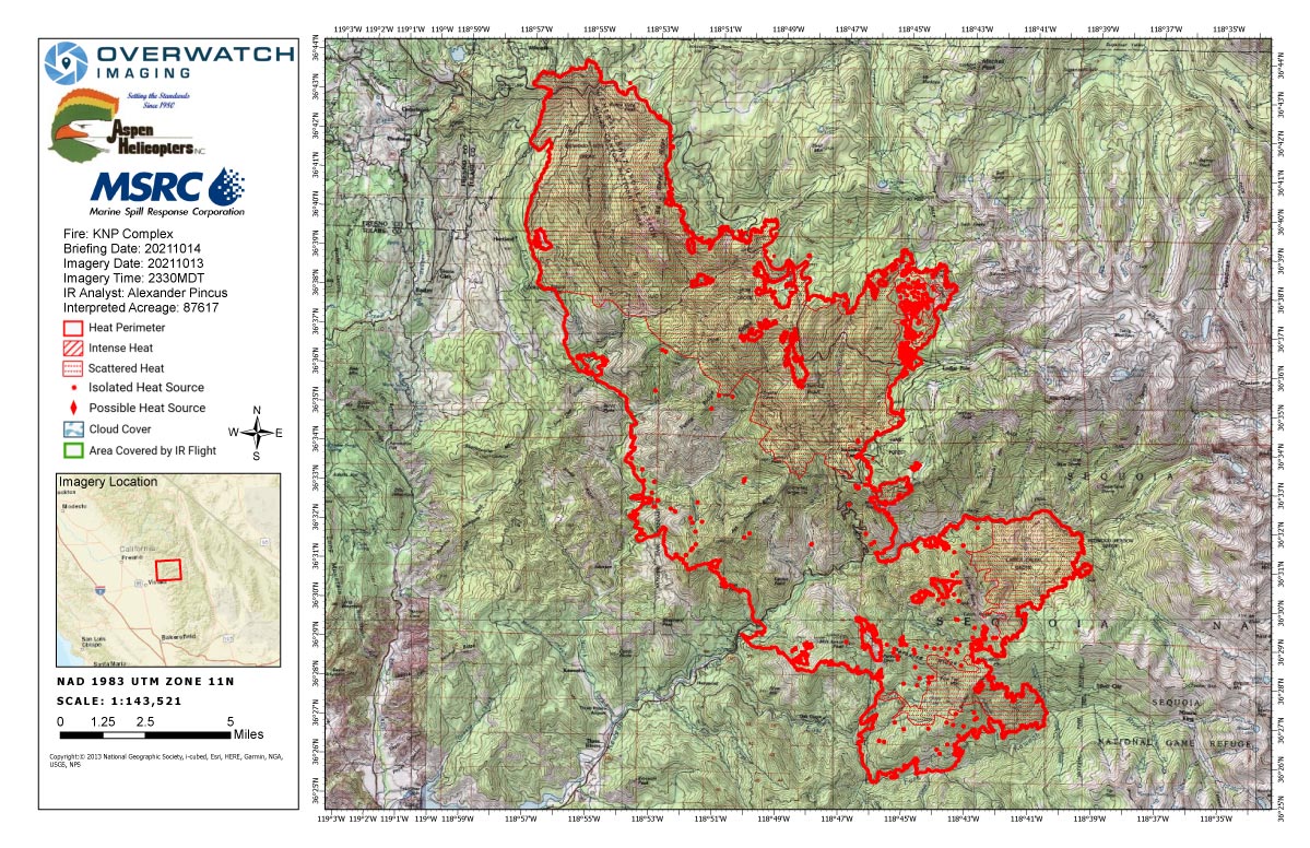
Thursday's Infrared Map
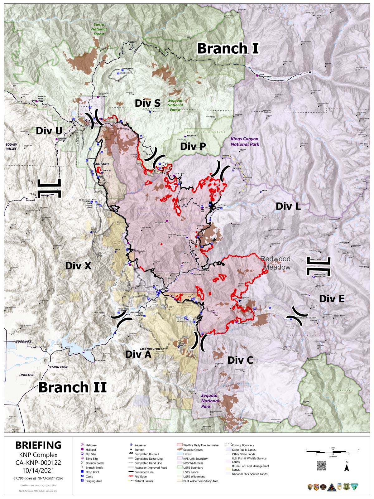
Note: Map is 1,200 pixels wide.
Click here for Friday's Updates: KNP Complex Wildfires in Sequoia National Park Friday, October 15, 2021 Updates
Update:
Tulare County Sheriff to Downgrade Evacuation Orders for Some Areas Impacted by the KNP Complex Fire
Effective immediately, Sheriff Boudreaux will downgrade Mineral King Road to the Sequoia National Park boundary from an Evacuation Order to Evacuation Warning. This will allow residents on Mineral King Road to the Park Gate to return to their residences.
At this time, Sequoia National Park is still closed to the public.
Sheriff Boudreaux, the National Park Service and the U.S. Forest Service want to remind everyone the National Forest and Sequoia and Kings Canyon National Park remain closed. Fire personnel and heavy equipment are still traveling throughout the area. Please be mindful of the personnel on the ground and equipment in the area.
Road Closures: Mineral King Road at the Park gate and the Milk Ranch/Oriole Lake Road at the Park Gates.
Remaining in an Evacuation Order: Upper Mineral King Road from the Park Gate, and the cabin communities of Cabin Cove, Silver City, and Mineral King. For more information please visit the Tulare County Sheriff's Facebook Page
Update: Acres: 87,786 acres
Containment: 45%
Start Date: September 10, 2021
Cause: Lightning
Jurisdiction: Sequoia and Kings Canyon National Parks; Sequoia National Forest
Resources: 1,588 personnel including: 26 crews, 92 engines, 38 water tenders, 9 dozers and 14 helicopters
Along the western flank of the KNP Complex today, crews will patrol and mop up along strong containment lines. No challenges are anticipated. In these areas, suppression repair will also commence. Suppression repair consists of actions designed to mitigate adverse effects to resources as a result of fire suppression activities. Resource advisors from public land management agencies with ownership within the KNP Complex have cooperatively developed site-specific repair recommendations and will monitor repair activities along roads, constructed fire lines, safety zones, drop points, and water sources. Restoring areas to pre-fire conditions is not immediately possible because vegetation recovery is necessary but preparing the land for recovery is critical to ensuring long-term health of the land.
Along the eastern and southern flanks, the fire is expected to produce more smoke which will settle in the valleys and canyons. From Montecito Lodge to Stony Creek, containment line construction will progress. Aerial operations will mostly be focused on the area of the fire upslope from the Middle Fork of the Kaweah River. Unmanned aircraft systems and drones will be utilized in areas too unsafe for crews to enter. Structure protection groups will be patrolling and monitoring the full perimeter of the fire, focusing on ensuring that previously identified values at risk are still intact and safe, and that suppression equipment is properly winterized.
Fire containment, returning residents back to their homes and communities, opening critical infrastructure, and restoration/repair of natural resources all remain incident objectives even through transition among management teams and firefighting resources. Although fire activity has slowed, safety of firefighters and the public is the top priority. Residents and visitors are reminded to remain vigilant to changing conditions, increased emergency response activity, and changing weather patterns which may impact weakened trees and create additional overhead hazards or ground instability.
Weather: Weather conditions will remain warm and dry through the end of the week. No appreciable changes other than a few clouds are anticipated through the end of the week.
Safety: Please be aware of and respect closures and reduce speeds when traveling in and around the fire area.
Evacuations: Evacuation ORDERS and WARNINGS are in place. For the most up-to-date information, visit: https://nifc.maps.arcgis.com/apps/webappviewer/index.html?id=4b2ac27b5c8943ed92c0e77aa94daca0. Learn to prepare for an evacuation by visiting https://www.readyforwildfire.org/.
Closures: Sequoia and Kings Canyon National Parks are closed west of the Pacific Crest Trail and south of the ridgeline which lies north of Ionian Basin. In addition, the BLM Case Mountain Extensive Recreation Management Area and major portions of the Sequoia National Forest are also closed. View closures at https://inciweb.nwcg.gov/incident/closures/7838/.
Smoke Impacts: Current air quality updates can be found at https://www.wildlandfiresmoke.net/outlooks/FresnoCA.
Basic Information
| Current as of | 10/14/2021, 8:14:42 AM |
| Incident Type | Wildfire |
| Cause | Lightning |
| Date of Origin | Friday September 10th, 2021 approx. 07:00 AM |
| Location | Sequoia National Park |
| Incident Commander | Michael Minton CAIIMT2 |
| Incident Description | Complex |
| Coordinates | 36.567 latitude, -118.811 longitude |
Current Situation
| Total Personnel | 1,588 |
| Size | 87,786 Acres |
| Percent of Perimeter Contained | 45% |
| Fuels Involved |
Timber (Litter and Understory) Chaparral (6 feet) Short Grass (1 foot) |
| Significant Events |
Fire behavior observed Minimal Creeping Smoldering Narrative: Little to no forward fire progression is expected on the fire. Fire-weakened trees will continue to fall. Main chances for forward progression will be from rollout. Expect mainly smoldering and creeping fire behavior. However, pockets of heavier fuels will continue to burn along with surface fuels under tight canopies. There is a minimal chance of spot fires from torching trees. Expect to see more open surface fire as one hour fuels have become more receptive to spot fires. |
Outlook
| Planned Actions |
Utilize direct tactics with ground resources.Holding and securing direct line. Continued protection and mitigation measures for all sequoia groves within and adjacent to the fire area. When attributes of fire behavior are favorable to the landscape, allow fire to spread to aid in fuels reduction in around the groves. Continue to patrol, monitor, and mop up. Continue work on suppression repair, where feasible. Repopulation is in progress, and continues. |
| Projected Incident Activity |
12 hours: Minimal fire activity. Moderate to good nighttime humidity recovery coupled with decreased number of hotspots and smokes due to available fuels be consumed, suppression action or humidity recovery great enough to put the heat out. Some heat has remained and primarily lies dormant/passive in stump holes, logs, snags, edges of interior pockets of unburned fuels and uncontained fireline and riparian areas. After gradually drying out again, fine dead fuels will become available again, heavies and other large diameter fuels will not be affected by the little precipitation and moisture, retaining seasonally low fuel moistures until a multi-day wetting event occurs. 24 hours: Minimal to moderate fire activity as fuels continue to dry out from the recent precipitation. Grass, broad and needle-leaf litter fuel beds will support surface fire on the south aspects. Potential for some torching trees will increase the chances of short-range spotting. 48 hours: Fine dead fuel moistures are readily available for ignition and fire spread. Minimal to moderate fire activity as fuels dry out and some increase where fuels are available. 72 hours: Minimal to moderate fire activity. Grass, broad- and needle-leaf litter fuel beds will support surface fire but low intensity in areas that underburned. Potential for some torching trees will increase the chances of short-range spotting. Anticipated after 72 hours: Minimal to moderate fire activity expected. Any areas where pockets of unburned fuels, uncontained fireline and fire activity exists expect an increase in activity as fuel moistures lower and dry out. |
Current Weather
| Weather Concerns |
Mostly sunny skies, light terrain driven winds and warmer temperatures prevailed over the fire today as high pressure built over the region. A weak weather system will pass to the north of the fire area on Thursday but other than a few clouds no appreciable changes to the weather will occur. Warmer and dry through the next few days. |
October 14, 2021 - KNP Complex Fire in Sequoia National Park updates for Thursday: 87,617 Acres with 40% Containment.
Overnight Infrared Flight Notes: Interpreted Size: 87,617 Interpreted Acres - Growth since last flight: About 9 Acres
-Very little growth
-interior continues to cool
Click here for: KNP Complex Wildfires in Sequoia National Park Wednesday, October 13, 2021 Updates
Thursday's Briefing Map
Briefing Map Shows Divisions, Uncontrolled Fire Edge, Completed Dozer Lines.
Note: Map is 1,200 pixels wide.