


California and National Drought Summary for November 16, 2021
Summary
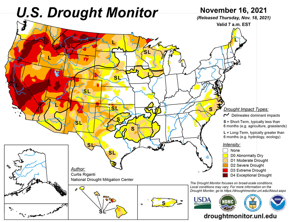
November 18, 2021 - Drier weather in the southwestern United States, western Great Plains, and Southeast led to drought conditions developing or worsening for parts of these regions this week. The northern Great Plains, western Great Lakes, the Northeast, and the Pacific Northwest saw significant precipitation this week, which led to improving drought conditions in parts of these regions. Slightly warmer than normal weather occurred in the Northeast, and warmer weather also occurred west of the Mississippi River. The warmest temperatures, compared to normal, were found in the northwestern Great Plains and in the West, with some areas seeing temperatures at least 6 degrees above normal. In Hawaii, drought conditions stayed the same or worsened after another drier week. Similar conditions occurred in Puerto Rico this week, where degrading conditions were spread across the island.
Northeast
Much of the Northeast region received at least a half inch of rain this week. Heavier amounts, locally reaching or exceeding 2 inches, fell in eastern Pennsylvania, New York, and New England. Temperatures were generally either near normal or a few degrees above normal. Some locations saw temperatures from 4 to 6 degrees warmer than normal, mostly in northern New England. Due to changing soil moisture and streamflow conditions, abnormal dryness evolved in coverage in northern West Virginia. No changes were made to the ongoing drought areas in northern New England. Recent precipitation, while beneficial in removing short-term drought, did not make up long-term precipitation deficits enough to result in changes to drought monitor categories.
Southeast
A quarter to a half inch of rain fell in western parts of the Carolinas and in northern Georgia and northeast Alabama. Near to slightly warmer than normal temperatures occurred in the Carolinas, while near to slightly cooler than normal temperatures occurred in Alabama and Florida. Outside of the aforementioned areas of rain, the weather this week was fairly dry in the region. Short-term drought continued to expand in southern Virginia, North Carolina, and South Carolina, where short-term precipitation deficits mounted and soil moisture lessened. The remainder of the region remained free of drought this week.
South
In the South this week, rain fell primarily to the east of Interstate 35 in Texas and Oklahoma, and in Arkansas, northwest Louisiana, and parts of Tennessee. Overall, though, the week was somewhat dry across the region. Along and west of I-35 in Texas and Oklahoma, temperatures generally ranged from 2 to 6 degrees above normal, and some areas locally reached 8 degrees above normal. East of there, temperatures were either near normal or slightly cooler than normal. In Texas and the Oklahoma Panhandle, drought conditions largely stayed the same or worsened, due to mounting short-term precipitation deficits, decreasing streamflow in some locations, high evaporative demand, and decreasing soil moisture in some areas. Moderate short-term drought also expanded in coverage in northern Louisiana, western Mississippi, western Tennessee, and southern Arkansas this week, where short-term precipitation deficits worsened and soil moisture decreased. Drought conditions in Arkansas, Louisiana, Tennessee, and east Texas, along the Red River, and in deep south Texas, are mostly short-term. Other areas experiencing drought in the South have drought conditions on both the short- and long-term.
Midwest
Much of the Upper Midwest saw significant precipitation this week, which led to some improvements in drought conditions. The biggest winners for precipitation totals were located from central Iowa to western Wisconsin and eastern Minnesota, where amounts of 1.5 to 2 inches were common. Temperatures in the Midwest region were relatively close to normal in most areas, though much of Missouri came in 2 to 4 degrees warmer than normal. The precipitation was sufficient to improve drought conditions in parts of Iowa, Wisconsin, and Minnesota. Additional drought condition improvements could occur in the Midwest next week after learning the effects of recent precipitation on soil moisture, streamflow, and other variables. A small area of central Wisconsin that missed out on heavier amounts saw its precipitation deficit grow, so moderate drought expanded there.
High Plains
The eastern edge of the High Plains region saw notable precipitation amounts this week, in particular the eastern parts of North Dakota and Kansas. Otherwise, largely dry weather ruled the week. Precipitation amounts were sufficient in northeast North Dakota to reduce long-term deficits enough to cause improvements in long-term drought. In eastern Colorado and western Kansas, drought worsened and expanded in some locations, as soil moisture continued to decrease and precipitation deficits on the short- and long-term continued to grow. Most of the High Plains saw a warmer than normal week, with the warmest temperature anomalies (4 to 10 degrees above normal) taking place in western Nebraska and Kansas, the western Dakotas, and eastern Colorado and Wyoming. Residual effects from the now mostly long-term drought continued in the Dakotas, where livestock producers had problems feeding herds due to alfalfa and hay shortages.
West
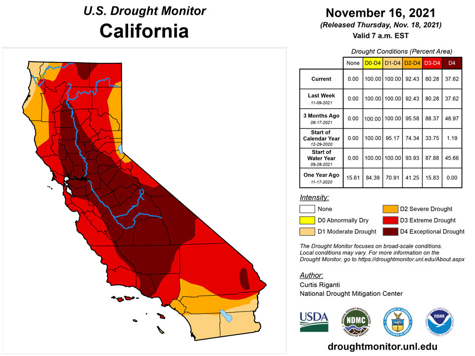
Mostly warmer than normal weather occurred in the West region this week. Many parts of the region saw temperatures range from 4 to 8 degrees above normal. Significant precipitation mostly occurred in the northern Sierra Nevada and in western Montana, northern Idaho, and in Washington and Oregon. In western Washington and Oregon, precipitation totals of 2 to 6 inches, with locally higher amounts, were common. Improvements were made to drought conditions in Washington, Oregon, Idaho, and western Montana where long-term precipitation deficits, soil moisture, and groundwater were improved the most. Conditions in south-central Wyoming and northwest Colorado also improved where short-term precipitation shortfalls had lessened and soil moisture had increased. In north-central Montana, short- and long-term precipitation deficits mounted and soil moisture and streamflow decreased, leading to the expansion of exceptional drought. In California, citrus crops have taken a hit as a result of the long-term drought conditions, and reservoirs continue to be very low.
Caribbean
Relatively dry weather enveloped Puerto Rico again this week. Streamflow decreased and short-term precipitation deficits continued to grow. As a result, moderate drought coverage increased along the southwest coast and in the northeast.
The U.S. Virgin Islands remained relatively dry for another week during a time of year that is typically the wettest, leading to a one-category degradation across the islands. St. Thomas received 0.5 to 1.0 inches of rain on the northern and western parts of the island and less to the southeast, according to the National Weather Service’s Quantitative Precipitation Estimates for the past 7 days. St. John and St. Croix each received 0.50 inches or less over most of the islands.
St. Thomas transitioned to D1-S from abnormal dryness last week. Precipitation at Cyril E. King AP was just 0.38 inches. The CoCoRaHS stations reported from 0.09 to 0.74 inches. The SPI values for the Cyril E. King Airport centered on moderate (D1) drought. The Grade School 3 Well on the island was 13.94 feet below land surface on Nov. 16, which is very low for the well.
Abnormal dryness was introduced on St. John. The Windswept Beach CoCoRaHS station reported 0.62 inches. Other CoCoRaHS stations reported from 0.50 to 0.54 inches. The SPI values centered on abnormal dryness for Windswept Beach. The Susannaberg DPW 3 Well on the island was at 14.81 feet below land surface on Nov. 16, which is very low for the well.
St. Croix went to D2-SL from D1-SL the previous week. Precipitation at Henry Rohlsen AP amounted to 0.05 inches. The CoCoRaHS stations reported from 0.08 to 0.65 inches. The SPI values centered on moderate to severe drought for Henry Rohlsen AP. The Adventure 28 Well on St. Croix was at 28.11 feet below the land surface, not far from matching the previous low of 28.32 feet set on the night of Oct. 31-Nov. 1, 2016.
Pacific
For the most part, temperatures were well below normal this week in Alaska. Temperatures from 5 to 20 degrees below normal were common outside of the Arctic Coast and southeast Alaska. Large snow water equivalent values were found in southern and central Alaska, and the state remained free of drought or abnormal dryness this week.
Drier weather enveloped Hawaii for the most part this week and streamflow decreased in many parts of the state, though there were a few locations that had heavier rainfall. On the Big Island, moderate, severe, and extreme drought expanded in coverage, and pasture conditions continued to struggle. Moderate drought expanded on Maui, Molokai, and Oahu this week.
The Republic of Palau continued to be free of dryness. Palau IAP and Koror reported 3.35 and 2.97 inches, respectively, for the week.
The Mariana Islands remained free of dryness. Guam received 1.12 inches this week, which is adequate, as these locations need one inch per week to meet minimum water needs. Rota recorded 0.76 inches, and received enough rain in previous weeks. All three gauges in Saipan received an inch or more.
The Federal States of Micronesia were mostly free of drought, apart from Kapingamarangi which remained at D2 and received no rain in the past two weeks. As reported in the Nov. 12 Drought Information Statement, most residential/private water tanks were running dry. Large community water tanks were at roughly 60% capacity. Crops and vegetation continued to yellow. Efforts were underway to increase water storage capacity for the community by constructing a water catchment system in Kapingamarangi in coming weeks.
Most other locations in the Federal States of Micronesia received 2 to 6+ inches in Chuuk, Fananu, Lukunor, Pingelap, Pohnpei and Woleai. Two inches of rain is adequate to meet minimum water needs. Kosrae and Nukuoro received less than 2 inches, but have received adequate rain in previous weeks. Ulithi and Yap were dry and on the cusp of abnormal dryness if more rain does not fall soon.
The Marshall Islands remained free of dryness. Majuro, Wotje, Ailinglaplap and Kwajalein reported 3 to more than 5 inches of rain, while Jaluit and Mili received less than 2 inches for the week, but have received enough rain in recent weeks.
American Samoa remained free of dryness. Pago Pago and Siufaga Ridge received 3.66 and 4.06 inches this week, while Toa Ridge reported 2.56 inches.
Looking Ahead
The Weather Prediction Center’s forecast (valid Nov. 17-24) shows a deep low pressure system over Canada affecting much of the central and eastern half of the Lower 48. The system’s warm front will bring a mix of snow, sleet, and freezing rain to the Northeast. Temperatures behind the front are expected to be up to 20 degrees above normal. The system’s cold front will push through the mid-section and eastern U.S. through Friday. It is expected to bring showers and thunderstorms to parts of the South and Southeast. Temperatures in the eastern half of the country are expected to drop 1 to 7 degrees below normal after the front passes. The cold air will set up lake-effect rain and snow showers over the Great Lakes. Meanwhile, a new storm system will affect the Pacific Northwest. This is expected to bring more rain and high elevation snow to the region. Temperatures across much of the West are expected to be 2 to 8 degrees above normal.
The Climate Prediction Center’s 8- to 10-day outlook (valid Nov. 24-30) favors below normal precipitation across much of the West and parts of the High Plains and Midwest. Above normal precipitation is favored from the eastern part of the Southwest along the Gulf Coast and into the Southeast. Above normal temperatures continue to be likely for the western U.S. Below normal temperatures are favored for much of the east.
Author(s):
Curtis Riganti, National Drought Mitigation Center
Denise Gutzmer, National Drought Mitigation Center
Dryness Categories
D0 Abnormally Dry—used for areas showing dryness but not yet in drought, or for areas recovering from drought.
Drought Intensity Categories
D1 Moderate Drought
D2 Severe Drought
D3 Extreme Drought
D4 Exceptional Drought
Drought or Dryness Types
S Short-term, typically less than 6 months (agriculture, grasslands)
L Long-term, typically more than 6 months (hydrology, ecology)
SL Area contains both short- and long-term impacts
Source: National Drought Mitigation Center
