


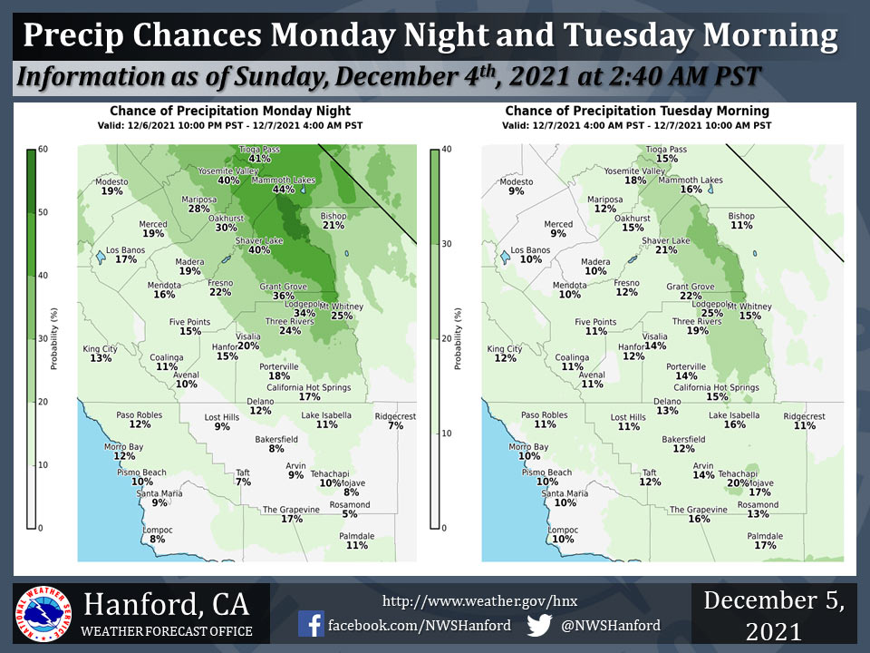
Note: Date is wrong on graphic: Actually Sunday, December 5th
Chance of Precipitation for Mariposa on Monday night: 28% - Tuesday morning: 12%
Chance of Precipitation for Oakhurst on Monday night: 30% - Tuesday morning: 15%
Chance of Precipitation for Mariposa on Monday night: 40% - Tuesday morning: 18%
December 5, 2021 - The National Weather Service Hanford Office reports a dissipating cold front will move southward through Central California Monday night.
This feeble atmospheric disturbance will be responsible for a chance of precipitation in the Sierra Nevada and a slight chance of precipitation in the San Joaquin Valley north of Kern County.
Precipitation amounts in the Sierra Nevada will remain below one quarter of an inch. Precipitation amounts, if any, in the San Joaquin Valley will remain well below one tenth of an inch.
Snow levels will be around 8,000 feet.
  Area Forecast Discussion
  National Weather Service Hanford CA
  219 AM PST Sun Dec 5 2021


  .SYNOPSIS...Dry conditions will prevail across the area, except
  for periods of low clouds with drizzle and fog over the Central
  Valley until Monday. A storm moving along the coast will bring a
  slight chance of precipitation on Monday night into Tuesday
  morning. Seasonably cool and dry conditions will prevail on
  Tuesday and Wednesday, and then a low pressure system will impact
  the area on Thursday and Friday that is expected to bring
  precipitation chances and much cooler temperatures.

  &&

  .DISCUSSION...Except for fog and low stratus clouds in the San
  Joaquin Valley, mainly clear skies and dry conditions will prevail
  until Monday. Dense fog will likely remain a problem for portions
  of the Central Valley until later this morning and could
  redevelop in the evening, depending on if low clouds clear out by
  the afternoon. Quite a few locations are reporting drizzle at
  times, so fog development could be inhibited in these areas.
  Daytime highs are expected to reach near or just below seasonal
  averages, at least in the San Joaquin Valley. Other areas in
  Central California will remain considerably warmer than average.
  So far tonight, the lowest visibility associated with dense fog
  is mainly in the southern San Joaquin Valley from around Visalia
  to Bakersfield. This weather pattern is due to a persistent
  upper-level ridge of high pressure in place.

  A brief break from the ridge pattern is expected on Monday evening
  into Tuesday as an upper-level low tracks southward off the coast
  of California. Some light showers remain a possibility in the
  Sierra Nevada. Fog development in the Central Valley will be less
  likely during this time, and a few light showers or sprinkles are
  possible.

  The high pressure will rebuild and be centered off the coast
  during midweek so that dry conditions will continue. However,
  valley fog development is a possibility during late Tuesday until
  Wednesday, given the time of year and expected pattern.

  Beginning Wednesday night, a stronger low pressure system will
  bring more widespread precipitation to Central California. Rain
  and mountain snow are in store for Thursday into Friday across
  much of our forecast area, with the bulk of precipitation
  occurring on Thursday. Rainfall in the region will be mainly light
  to moderate, but generally welcome. Local brief heavy
  precipitation is possible, so we will monitor this potential over
  any burn scars. Also expect several inches of snow in the Sierra
  Nevada, mainly at elevations above 6,000 feet. The probabilities
  of at least one half an inch of rain for Thursday in the Central
  Valley remain at around 20 to 35 percent. As for snow in the
  Sierra Nevada, the most likely amounts will be around five to
  nine inches mainly from Yosemite to Sequoia NP, with lesser
  amounts to the south. There is about a 20 percent chance that
  higher amounts, or around a foot, may occur towards Yosemite.
  Otherwise, total rainfall of around 0.50 to 1.00 inch is projected
  below 6,000 feet in the lower Sierra.

  For next weekend, the high pressure ridge pattern will likely
  return, based on ensemble guidance. It does not appear a blocking
  pattern will resume over the West Coast as in recent days, so it
  is possible another storm system could soon follow, perhaps by the
  early part of next week.

  &&


  .AVIATION...
  Areas of MVFR visibilities due to haze/mist with ceilings at or
  below 500 feet due to stratus, along with drizzle at times, will
  prevail over the San Joaquin Valley. However, LIFR conditions are
  expected in the San Joaquin Valley, mainly south of FAT, until 19Z
  Sunday due to dense fog. Otherwise, VFR conditions will prevail
  over the next 24 hours throughout the Central CA interior.

  &&

  .AIR QUALITY ISSUES...
  On Sunday December 5 2021... Unhealthy for sensitive groups in
  Fresno... Kern... Kings and Tulare Counties.  Fireplace/Wood Stove
  Burning Status is: No Burning Unless Registered in Kern (Greater
  Frazier Park Area)... Kings... Madera... Merced and Tulare
  Counties. No Burning For All in Fresno and Kern Counties.
  Further information is available at Valleyair.org
Source: NWS
