


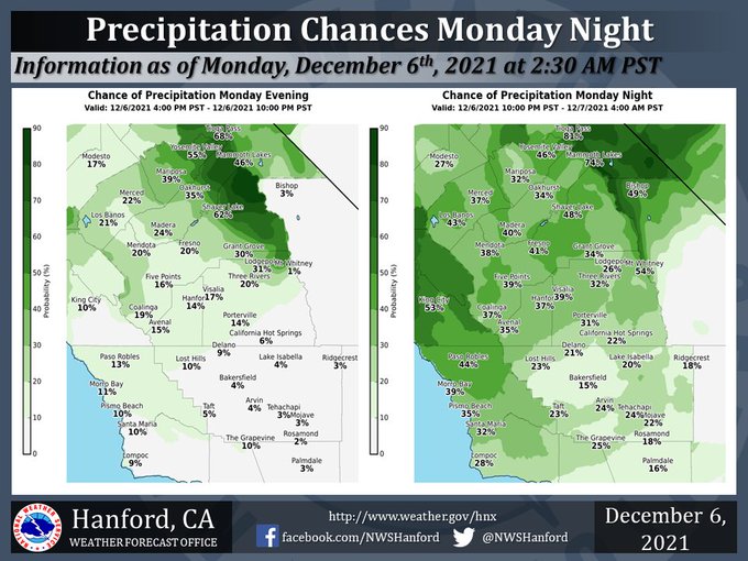
Chance of Precipitation for Mariposa on Monday evening: 39% - Monday night: 32%
Chance of Precipitation for Oakhurst on Monday evening: 35% - Monday night: 34%
Chance of Precipitation for Yosemite Valley on Monday evening: 55% - Monday night: 46%
December 6, 2021 - The National Weather Service Hanford Office reports a trough of low pressure will pass through Central California Tuesday morning.
Ahead of this trough of low pressure, precipitation is likely in the Sierra Nevada Monday night, while there is a chance of light rain in the San Joaquin Valley Monday night.
Rain amounts, if any, in the San Joaquin Valley will remain below one tenth of an inch.
Two to four inches of snow is possible in the Sierra Nevada above 8,000 feet.
  Area Forecast Discussion
  National Weather Service Hanford CA
  1252 AM PST Mon Dec 6 2021

  .SYNOPSIS...
  Light precipitation is possible tonight and Tuesday morning ahead
  of a trough of low pressure. A more organized storm system will be
  responsible for widespread precipitation across Central California
  Wednesday night through Thursday evening. Freezing temperatures
  are likely in the Kern County desert and most of the San Joaquin
  Valley Friday night.

  &&

  .DISCUSSION...
  A ridge of high pressure will shift southward over Southern
  California today. High temperatures in Central California this
  afternoon will be near normal for this time of year. A trough of
  low pressure will move southward through Northern California
  tonight. This trough of low pressure will pass over Central
  California Tuesday morning. Precipitation amounts of up to one
  quarter of an inch are expected in the Sierra Nevada tonight and
  Tuesday morning. Two to four inches of snow is possible in the
  Sierra Nevada above 8,000 feet tonight and Tuesday morning. There
  is a slight chance of light rain in the San Joaquin Valley tonight
  and Tuesday morning. Precipitation amounts, if any, will remain
  below one tenth of an inch.

  Zonal flow aloft is expected Tuesday afternoon through Wednesday.
  An Eastern Pacific cold front will approach the coast of
  California Wednesday night. This cold front will move eastward
  through Central California Thursday. Ahead of the cold front,
  widespread precipitation is likely. Rain amounts will remain under
  one tenth of an inch in the Coastal Range and Kern County desert.
  Precipitation amounts of one tenth of an inch to one quarter of
  an inch are possible in the western portion of the San Joaquin
  Valley and the Kern County mountains. Rainfall of one quarter of
  an inch to one half of an inch is conceivable in the eastern
  portion of the San Joaquin Valley. Finally, below the snow line,
  rain amounts of one half of an inch to one inch are possible in
  the Sierra Nevada and adjacent foothills. Speaking of the snow
  line, snow levels will start at around 7,000 feet Wednesday night,
  before falling to about 5,000 feet Thursday afternoon. Snow
  amounts of 6 to 12 inches are possible in the Sierra Nevada above
  7,000 feet. Snow amounts of 3 to 6 inches are conceivable in the
  Sierra Nevada from 5,000 feet to 7,000 feet.

  In wake of the aforementioned cold front, a relatively colder air
  mass will move into Central California Thursday night. Low
  temperatures Thursday night will be six to eight degrees colder
  than Wednesday night. High temperatures Friday afternoon will be
  around five degrees below normal for this time of year. Freezing
  temperature are probable in the Kern County desert and much of the
  San Joaquin Valley Friday night. Probabilities of freezing
  temperatures in the San Joaquin Valley Friday night are 64 percent
  or higher at Madera, Visalia, Hanford, Merced, Delano, and
  Lemoore. A Hard Freeze Watch will likely be required for the Kern
  County desert Friday night, while a Freeze Watch will likely be
  required for the San Joaquin Valley Friday night. An upward
  temperature trend is expected this weekend as cyclonic flow aloft
  transitions to anticyclonic flow.

  &&

  .AVIATION...
  IFR to local LIFR conditions are expected in the San Joaquin
  Valley this morning due to stratus clouds. These stratus clouds
  should lift to a MVFR deck this afternoon. MVFR or lower
  conditions are possible in the Sierra Nevada tonight due to light
  precipitation ahead of a trough of low pressure.

  &&

  .AIR QUALITY ISSUES...
  On Monday, December 6th, 2021, unhealthy for sensitive groups in
  Fresno and Kern Counties. Fireplace/wood stove burning status is:
  no burning unless registered in Kern (Greater Frazier Park Area),
  Kings, Madera, Merced, and Tulare Counties. No burning for all in
  Fresno and Kern Counties. Further information is available at
  Valleyair.org.
Source: NWS
