


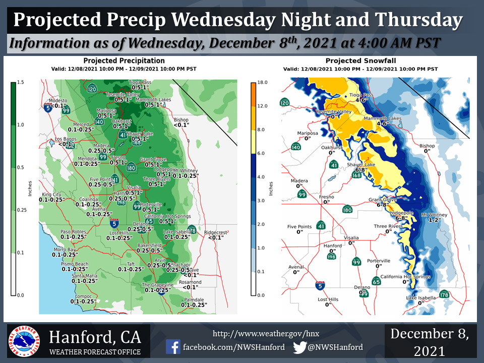
Projected Precipitation for Mariposa 0.50" - 1.00"
Projected Precipitation for Oakhurst 0.50" - 1.00"
Projected Precipitation for Yosemite Valley 0.50" - 1.00"
December 8, 2021 - The National Weather Service Hanford Office reports a cold front will move eastward through Central California Thursday.
Widespread precipitation is likely ahead of and along this cold front tonight and Thursday.
The majority of this precipitation will fall late tonight and Thursday morning.
Snow levels will drop from around 7,000 feet tonight to about 5,000 feet by Thursday morning.
A Winter Weather Advisory is in effect for the Sierra Nevada from 7:00 P.M. this evening until 4:00 P.M. Thursday afternoon.
  Area Forecast Discussion
  National Weather Service Hanford CA
  433 AM PST Wed Dec 8 2021


  .SYNOPSIS...
  A frontal system will impacts the region tonight and Thursday with
  rain and mountain snow. Sub-Freezing temperatures are likely in
  the Kern County deserts and much of the San Joaquin Valley Friday
  night and Saturday morning. A slow moving and robust storm system
  may impact our area early next week, bringing significant
  precipitation with it.

  &&

  .DISCUSSION...
  A weak shortwave ridge is nudging over central California behind
  an exiting trough, with some high cloudiness dropping over the top
  of the ridge. Some patchy dense fog has been developing at the
  surface and lifting in some areas to a low stratus deck. The
  extent and persistence of fog will be watched carefully this
  morning and a Dense Fog Advisory may be appropriate. Meanwhile,
  temperatures are seasonably cool across the area this morning.

  The next approaching low pressure system is pushing through the
  Pacific Northwest area and as additional energy and moisture swings
  southward, we will see precipitation pushing through central
  California by later this evening. Blended model guidance is
  trending drier with QPF from this system, but still indicates high
  probabilities of significant snowfall accumulations in the Sierra
  zones, with as much as 12-14 inches possible at the highest
  elevations. Snow levels will lower to around 5000 feet, and
  around 5-10 inches is expected to accumulate. A Winter Weather
  Advisory is in effect from 7 PM this evening through 4 PM
  Thursday. A couple of inches is possible over the higher Kern
  County mountains, but not expected to impact the pass areas. San
  Joaquin Valley rainfall totals will be generally around 1/4 to 1/2
  inch, with up to an inch in the foothills and a few hundredths in
  the desert areas.

  A cold and dry northerly flow behind the system will bring
  freezing temperatures to much of the area, and Saturday morning
  lows in much of the Kern County desert area will likely be below
  28 degrees. Temperatures in the San Joaquin Valley will drop to
  around the freezing mark. A more potent low pressure system is
  progged to drop into our area beginning Sunday and will bring
  more significant rain and mountain snow for early next week.


  &&


  .AVIATION...
  MVFR to IFR ceilings and visibility in the SJ Valley through 18z
  Wednesday in haze and mist. After 06Z Thursday, areas of MVFR and
  IFR with local LIFR and mountain obscuration in clouds and
  precipitation will spread southward across the region. Otherwise,
  VFR conditions will prevail across the central CA interior for
  the next 24 hours.

  &&

  .AIR QUALITY ISSUES...
  On Wednesday December 8 2021... Unhealthy in Kern County.
  Unhealthy for sensitive groups in Fresno... Kings... Madera and
  Tulare Counties.  Fireplace/Wood Stove Burning Status is: No
  Burning Unless Registered in Kern (Greater Frazier Park Area)...
  Kings... Merced and Tulare Counties. No Burning For All in
  Fresno... Kern and Madera Counties.
  Further information is available at Valleyair.org
Source: NWS
