


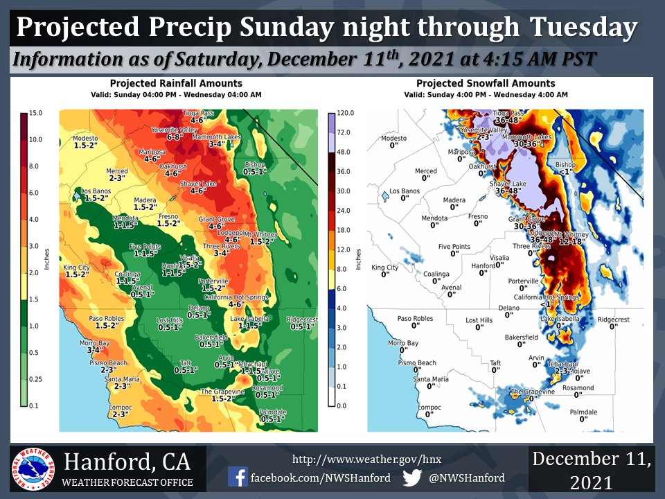
Projected Precipitation for Mariposa 4.00" - 6.00"
Projected Precipitation for Oakhurst 4.00" - 6.00"
Projected Precipitation for Yosemite Valley 6.00" - 8.00"
December 11 ,2021 - The National Weather Service Hanford Office reports a strong storm system will bring periods of moderate to heavy precipitation early next week.
Precipitation will begin Sunday night with the heaviest ran and snow expected Monday evening through Tuesday afternoon.
Snow levels will be around 5000 to 6000 feet for most of the event but will fall to around 3000 feet as the precipitation winds down Tuesday night.
  Area Forecast Discussion
  National Weather Service Hanford CA
  402 AM PST Sat Dec 11 2021

  .SYNOPSIS...Dry and cool conditions will prevail today. Sub
  freezing conditions are likely in the Kern Desert again tonight.
  A slow moving storm system may bring significant precipitation
  from late Sunday night through Tuesday evening. Another storm is
  expected to bring additional precipitation to the area on
  Thursday.

  &&

  .DISCUSSION...A cold northwest flow ahead of a high pressure
  center off the CA coast is providing for the coldest temperature
  readings in the San Joaquin Valley and Kern County Deserts in
  almost 10 months. Temperatures across the Kern County Deserts
  have already plunged below 28 Deg F at several stations and the
  Hard Freeze Warning that had been issued for the Mojave Desert and
  the Indian Wells Valley should easily verify this morning. Across
  the San Joaquin Valley, temperatures have already dropped into
  the mid 30s at several stations and are expected to drop below the
  freezing mark by daybreak. As a result, much of the San Joaquin
  valley is expected to have it`s first freeze of the season. Skies
  are mainly clear across our area with some thin high clouds noted
  by satellite imagery. The fog loop is showing a narrow strip of
  fog from Fresno southward through far western Tulare County, but
  the fog will be localized this morning due to the prevailing dry
  airmass.

  Following a mostly sunny and relatively cold day today, the flow
  aloft is progged to shift from northwest to west tonight and
  mid/high clouds will increase from north to south as a strong
  storm drops southward out of the Gulf of AK and takes aim at
  central CA. The increased clouds will result in temperatures
  tonight remaining above the freezing mark at most locations.
  However, the Kern County Deserts are expected to remain mainly
  clear with light winds. This will allow for good radiational
  cooling to take place once again and another night of temperatures
  below 28 Deg F is possible. A Hard Freeze Watch remains in effect
  for the Kern County Deserts for tonight and Sunday morning.

  The storm is progged to deepen off the PAC NW coast on Sunday
  which will push precipitation southward into central CA during
  the day. Precipitation will be possible from Fresno northward by
  Sunday afternoon with the snow level between 5000 and 6000 feet.
  The precipitation is expected to push further southward on Sunday
  night and become more widespread across our area by Monday
  morning. A very wet period is expected across our area Monday
  through Tuesday evening. Latest QPF progs are indicating 1 to 2
  inches of rain across most of the San Joaquin Valley during this
  time frame. Between 2 and 5 inches of rain is expected over the
  Sierra foothills and 3 to 7 inches of liquid precipitation across
  the higher Sierra Nevada. Heavy snowfall is expected above 5000
  feet and several feet of new snow are likely above 7000 feet. A
  Winter Storm Watch remains in effect for the higher Sierra Nevada
  between Monday morning and Wednesday morning. Significant
  precipitation is also expected across the Kern County Mountains
  and Deserts with 1 to 2 inches of liquid precipitation in the Kern
  County Mountains and a half inch to an inch of rainfall in the
  Deserts. Snow levels are expected to remain above the major passes
  in Kern County until Tuesday evening, but some light snowfall is
  possible on the passes late Tuesday evening.

  The slow moving storm is expected to move out of our area on
  Wednesday. Another storm is progged by the medium range models to
  move through central CA on Thursday bringing additional
  precipitation to our area. The medium range ensemble means are
  indicating that this system will move out of our area on Friday
  and high pressure will bring drier conditions to our area next
  weekend.

  &&

  .AVIATION...In the San Joaquin Valley, areas of MVFR and local IFR
  visibility in mist and haze through 20Z Sat. Otherwise, VFR
  conditions will prevail across the central CA interior for the
  next 24 hours.

  &&

  .AIR QUALITY ISSUES...On Saturday December 11 2021...
  Fireplace/Wood Stove Burning Status is: No Burning Unless
  Registered in Fresno... Kern... Madera and Tulare Counties.
  Further information is available at Valleyair.org
Source: NWS
