


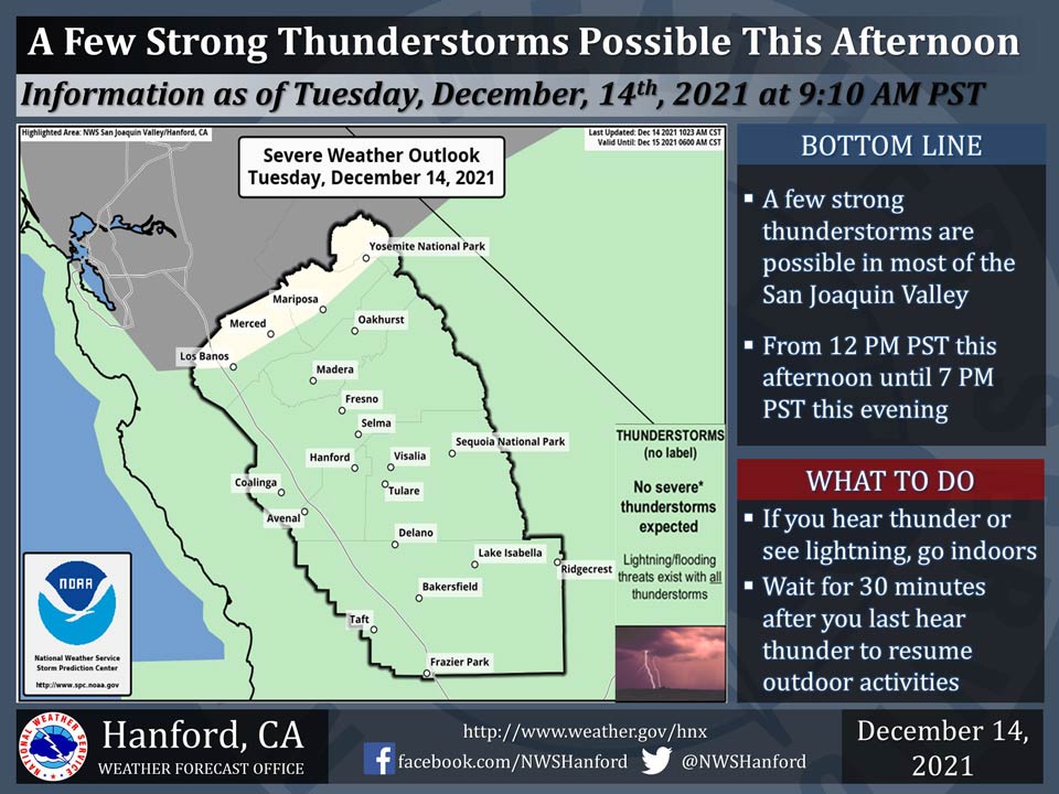
December 14, 2021 - The National Weather Service Hanford Office reports a few strong thunderstorms possible in most of the San Joaquin Valley this afternoon into this evening.
Dangerous lightning, small hail, and wind gusts near 45 mph are strong thunderstorm hazards.
Any thunderstorm can produce intense rain, leading to localized flooding.
  Area Forecast Discussion
  National Weather Service Hanford CA
  523 AM PST Tue Dec 14 2021


  .SYNOPSIS...Widespread light to moderate precipitation will continue
  this morning before tapering off from the north this afternoon and
  into the evening. There is a slight chance of thunderstorms late this
  morning through the afternoon. Strong wind gusts will continue in the
  Kern County Mountains and Desert through this evening. A weak system
  will bring a little additional precipitation to the area on Thursday.

  &&

  .DISCUSSION...
  Radar imagery shows widespread precipitation across the district as
  a strong storm system impacts the west coast. Some impressive rain
  amounts are already showing up with nearly 5 inches of rain thus far
  at Wawona RAWS in the foothills of Mariposa County. El Portal RAWS
  and Jerseydale RAWS have received around 3 inches of rain and in the
  San Joaquin Valley, Merced airport has nearly 1.25". Rain shadowing
  has limited amounts farther south in the SJ Valley. Precipitation will
  remain widespread through the morning then start to diminish from the
  northwest in the afternoon. The air mass will become more unstable as
  colder air aloft moves in later this morning. There is a slight chance
  of thunderstorms from late morning through early evening with the main
  threats being dangerous lightning, brief heavy rainfall, and small hail.
  Snow levels are running around 5000 feet across the Sierra Nevada and
  near 6000 feet in the Kern County Mountains. The Winter Storm Warning
  remains in effect for the Sierra Nevada until 10 PM this evening. Snow
  levels will lower near 2500 to 3000 feet later today as precipitation
  winds down with a dusting to some light accumulations possible. The
  Winter Storm Warning for the Kern County Mountains remains in effect
  until Midnight. Snow levels will fall to near 4000 feet later this
  morning with accumulating snowfall possible on the major passes such
  as Interstate 5 over the Grapevine and Highway 58 through the Tehachapi
  Pass. Latest forecast estimates give 3 to 6 inches over Tehachapi Pass.
  A Winter Weather Advisory goes into effect at 10 AM for the Grapevine
  and runs until Midnight, with potential for 1 to 3 inches of snowfall.
  Winds have subsided across much of the SJ Valley but strong gusts are
  continuing across the mountains and now in the Desert. A Wind Advisory
  has been issued for the Desert and adjacent slopes through Midnight.

  Dry weather and lighter winds will prevail on Wednesday but the next
  storm system will begin to spread precipitation in from the north on
  Wednesday night. While not nearly as strong as the current system, it
  could bring some decent precipitation amounts across the mountains
  through Thursday. Dry weather is expected Friday through the weekend
  then a slight chance of precipitation returns on Monday as a closed
  low pressure system drops down off the coast.

  &&

  .AVIATION...Areas of MVFR and local IFR conditions in rain across
  the San Joaquin Valley through 21Z Tuesday. Local MVFR to IFR in
  showers and isolated thunderstorms from 21Z through 02Z Wednesday.
  IFR and mountain obscurations in heavy rain and snow across the
  Sierra Nevada and the Kern County mountains through 06Z Wednesday.

  &&

  .AIR QUALITY ISSUES...
  On Tuesday December 14 2021...Fireplace/Wood Stove Burning Status is:
  No Burning Unless Registered in Kern County. Further information is
  available at Valleyair.org
Source: NWS
