


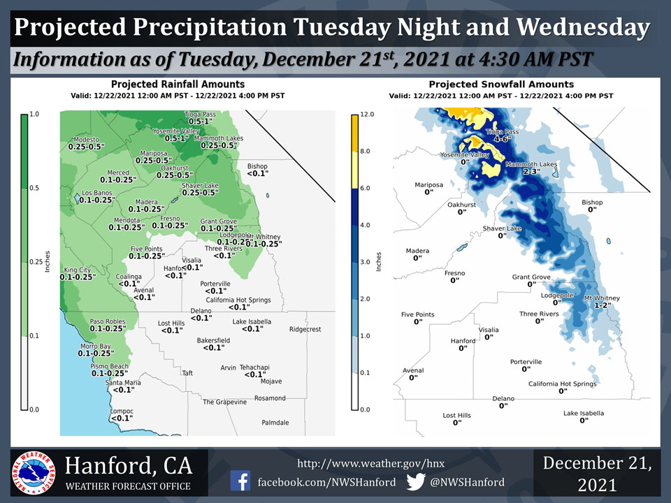
Projected Precipitation for Mariposa 0.25" - 0.50"
Projected Precipitation for Oakhurst 0.25" - 0.50"
Projected Precipitation for Yosemite Valley 0.50" - 1.00"
December 21, 2021 - The National Weather Service Hanford Office reports a the first in a series of atmospheric disturbances will impact Central California after midnight Tuesday night and Wednesday.
Most of this precipitation will fall Wednesday afternoon.
Much larger amounts of rain and snow are likely Wednesday night into the holiday weekend.
  Area Forecast Discussion
  National Weather Service Hanford CA
  311 AM PST Tue Dec 21 2021


  .SYNOPSIS...
  Cool and mainly dry conditions continue through most of the day
  Tuesday. Periods of occasionally moderate to heavy rain and
  mountain snow will begin by Tuesday night and continue into early
  next week.

  &&

  .DISCUSSION...
  A cool raw day in the San Joaquin valley yesterday due to a
  stubborn low stratus cloud cover. Most locales reported less than
  a 5 degree difference between the low and high temperature. The
  low clouds have been lowering to less than 1kft and will likely
  result in some patchy fog forming this morning. Some subtropical
  moisture has been streaming in from the southwest, making it
  difficult to see the lower level cloud cover on the differencing
  fog channel. Think the low stratus deck should mix out this
  afternoon due to an increasing low level south flow. Otherwise the
  remaining of the forecast area should see sunshine with some mid
  and high level clouds.

  Ensemble model solutions in fair agreement that dry pattern will
  turn wet by midweek and turn cooler and wet during the Christmas
  weekend. A storm off the pacific Northwest Coast will shift
  towards west coast as several short waves move through the north
  flow out of Alaska. 500MB cluster analysis show lots of variance
  in the timing of individual short waves. Models show subtropical
  moisture moving from the southwest with well above normal
  precipitable water across Central CA on Wednesday. The high
  moisture with atmospheric river values could last until Christmas
  morning.

  Precipitation associated with the incoming low pressure system is
  progged to begin impacting our area as late Tuesday night,
  spreading southward across the area through the day Wednesday.
  Snow levels will rise above 7000 feet in the warm southwesterly
  flow ahead of the approaching system. Rainfall amounts ranging
  from around 1/10 of an inch in the south San Joaquin Valley to 1/4
  inch farther north can be expected initially, with a bit higher
  amounts in the foothills. Where snow does accumulate in the higher
  elevations, around 8 to 16 inches is likely. A winter Weather
  Advisory is in effect for the Sierra Nevada from Sequoia National
  Park northward Tuesday night and Wednesday.

  Additional waves of energy will bring further precipitation across
  central California Wednesday night through the Christmas holiday
  weekend. Larger accumulations of rain and snow will occur, and
  snow levels will lower as colder air moves into the region. By
  Thursday snow levels begin lowering and will be down to around
  4000 ft by Friday, then as low as 3500 ft over the weekend. With
  additional widespread snow accumulations of 1 to 5 feet expected,
  A Winter Storm Warning has been issued for the Sierra north of
  Lake Isabella from Wednesday afternoon through Sunday afternoon.
  In addition to the snow, San Joaquin Valley locations will
  receive around 1 to 1.5 inches of rainfall, with around 2-3 inches
  in the foothills and 1/2 to 3/4 of an inch in the desert areas.
  Temperatures will run close to seasonal averages but turn cooler
  during the weekend due to a strong ridge over the NPac providing
  a cold north flow out of Alaska.


  &&


  .AVIATION...
  Widespread IFR and and local LIFR visibilities and ceilings in
  mist/fog and stratus across the San Joaquin Valley through 18z
  Tuesday. Otherwise, VFR conditions will prevail across the
  central CA interior for the next 24 hours.

  &&

  .AIR QUALITY ISSUES...
  On Tuesday December 21 2021... Fireplace/Wood Stove Burning Status
  is: No Burning Unless Registered in Fresno... Kern... Kings...
  Madera... Merced and Tulare Counties.
  Further information is available at Valleyair.org
Source: NWS
