


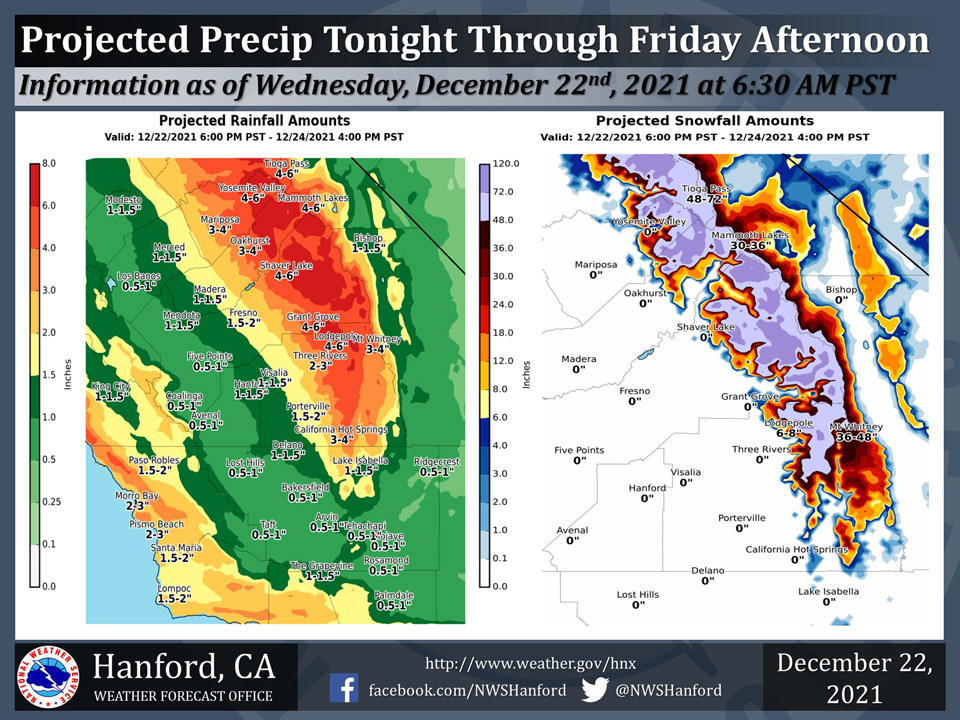
Projected Precipitation for Mariposa 3.00" - 4.00"
Projected Precipitation for Oakhurst 3.00" - 4.00"
Projected Precipitation for Yosemite Valley 4.00" - 6.00"
December 22, 2021 - The National Weather Service Hanford Office reports periods of moderate to occasionally heavy precipitation are expected in Central California tonight through Friday afternoon.
Extreme winter conditions are likely in the Sierra Nevada above 7,000 feet due to snow load and blowing snow.
The majority of this precipitation will fall Thursday.
  Area Forecast Discussion
  National Weather Service Hanford CA
  1229 AM PST Wed Dec 22 2021

  .SYNOPSIS...
  Dense fog will impact the central and southern portions of the San
  Joaquin Valley this morning. Periods of moderate to occasionally
  heavy precipitation are expected tonight through Friday. There may
  be a break in unsettled weather Friday night, before precipitation
  returns to Central California Saturday. Snow levels could fall to
  Kern County mountain pass levels Saturday night.

  &&

  .DISCUSSION...
  Dense fog has formed in the central and southern portions of the
  San Joaquin Valley this morning, resulting in a high
  transportation risk. Highways affected include, but are not
  limited to Highway 198, Highway 41, Highway 43, Highway 180, and
  Highway 99 south of Madera. If driving, slow down, use low beam
  headlights, and keep plenty of distance between your vehicle and
  the vehicle in front of you.

  A prolonged period of unsettled weather is expected tonight into
  the upcoming holiday weekend. Two to four feet of snow is likely
  in the Sierra Nevada above 5,000 feet, with isolated amounts up to
  six feet above 7,000 feet tonight through Friday afternoon.
  Extreme winter weather conditions are expected in the Sierra
  Nevada tonight through Friday afternoon due to snow load and
  blowing snow. Below the snow line, four to six inches of rain is
  possible in the Sierra Nevada foothills tonight through Friday
  afternoon, which could cause mudslides, rockslides, and debris
  flow flooding. One half of an inch to one inch of rain is probable
  in the western portion of the San Joaquin Valley and Coastal
  Range tonight through Friday afternoon. One to two inches or rain
  is likely in the eastern portion of the San Joaquin Valley tonight
  through Friday afternoon.

  There could be a break in unsettled weather Friday night, before
  precipitation returns to Central California Saturday. In the
  Sierra Nevada, snow levels will start at around 4,000 feet
  Saturday, before falling to about 3,000 feet Saturday night. In
  the Kern County mountains, snow levels will start at around 5,000
  feet Saturday morning. Snow levels in the Kern County mountains
  could fall to pass levels Saturday afternoon or Saturday night,
  resulting in light snow along Interstate 5 over Tejon Pass and
  light snow along Highway 58 over Tehachapi Pass as early as
  Saturday afternoon and more likely Saturday night. Motorists
  driving over these major mountain passes should be prepared for
  slick, hazardous roads and travel delays as early as Saturday
  afternoon. In the Sierra Nevada, an additional one to two feet of
  snow is possible Saturday and Saturday night. In the San Joaquin
  Valley, rain amounts should remain under one half of an inch
  Saturday and Saturday night.

  Another break in the unsettled weather is possible Sunday and
  Sunday night, before precipitation returns to Central California
  early next week. Stay tuned for specific information regarding
  this storm system.

  &&

  .AVIATION...
  LIFR conditions due to dense fog in the San Joaquin Valley will
  improve to MVFR conditions late this morning. MVFR conditions are
  likely in and near showers this afternoon and tonight. Local IFR
  conditions are expected in the Sierra Nevada through at least the
  next 24 hours.

  &&

  .AIR QUALITY ISSUES...
  On Wednesday, December 22nd, 2021, unhealthy for sensitive groups
  in Kern County. Fireplace/wood stove burning status is: no burning
  unless registered in Fresno, Kings, Madera, Merced, and Tulare
  Counties. No burning for all in Kern County. Further information
  is available at Valleyair.org.
Source: NWS
