


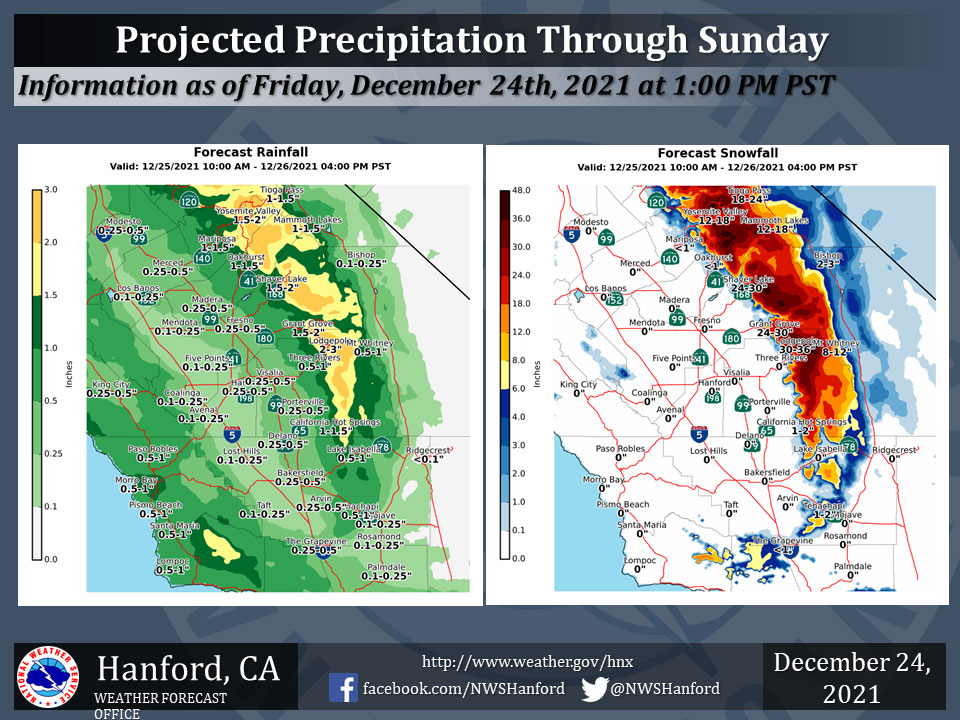
Projected Precipitation for Mariposa 1.00" - 1.50"
Projected Precipitation for Oakhurst 1.00" - 1.50"
Projected Precipitation for Yosemite Valley 1.50" - 2.00"
December 24, 2021 - The National Weather Service Hanford Office reports a cold storm system will move into the region Saturday afternoon into Sunday morning with snow levels dropping to 2000 feet.
Snow will drop down into the foothill communities Saturday night into Sunday morning.
Locally heavy snow is expected overnight Saturday.
  Area Forecast Discussion
  National Weather Service Hanford CA
  149 PM PST Fri Dec 24 2021


  .SYNOPSIS...A very wet weather pattern will continue through the
  holiday weekend with brief breaks as several weather disturbances
  move into and across the Central California Interior. Heavy
  mountain snow and significant lower elevation rain will occur
  through the middle of next week.

  &&

  .DISCUSSION...
  We are in the midst of another semi-break in action for the central
  California Interior. As with all of the expected breaks we still
  expect a threat of showers for many locations but on the whole the
  precipitation will be very light. Once the breaks end then the
  light to moderate precipitation commences. Todays break will
  continue through tomorrow late morning/early afternoon and
  then chances for precipitation greatly increases once again. This
  parade of precipitation is all caused by a seasonably semi-
  permanent high setting up over the Pacific Ocean just southwest of
  the Gulf of Alaska and the mid-latitude energy in the northern
  hemisphere pushes up and over the ridging and drops southward on
  the eastern periphery of the high into the SW Conus. This actually
  looks to continue into the New Year. So in the long term expect
  breaks in the precipitation followed by more activity.

  As for the next several days a colder system will move into the
  region beginning tomorrow late afternoon and into Sunday. Snow
  levels will drop from the current 6,000 to 7,000 foot heights down
  to 4,000 to 3,500 feet by Saturday (Christmas) evening and then
  down to 2,500 to 2,000 feet by early Sunday morning. The colder
  temperatures will be associated with another batch of
  precipitation Saturday evening into Sunday morning so the threat
  of foothill snowfall will be present. A Winter Storm Watch is
  currently in effect for the Sierra foothills and the Kern County
  Mountains until Monday morning to bring attention to this fact.
  As far as the passes are concerned the Walker and the Tehachapi
  Passes will have the greatest chances of seeing snowfall. There is
  a 44 percent chance of 1 inch or greater snowfall for Tehachapi on
  Saturday evening into Sunday morning. Meanwhile, the snow levels
  will be a bit higher for the Tejon Pass area (Grapevine) to around
  3,500 feet and the precipitation amounts will be less leaving
  about a 25 percent chance of a trace of snowfall on the Grapevine
  pass by Sunday morning. Again keep in mind that traffic levels
  could be higher due to the Holidays and even a trace of snowfall
  on the Grapevine could cause slowdowns. Snowfall on any of the
  passes is sure to at the very least slow things down but road
  closures could occur, so before traveling do yourself a favor and
  call our CalTrans friends` road condition hotline at
  1-800-927-7623 and potentially save you from being stuck in
  traffic or turning around to use another route.

  Another brief break is expected Sunday afternoon through Sunday
  evening when another cold system begins to enter the northern
  parts of the CWA and will move southward through Monday night.
  Snow levels look to drop to 2,000 to 1,500 feet increasing
  chances of low elevation snowfall. However, by the time this
  happens most of the precipitation chances will be minimal. But, if
  some of the precipitation hangs around longer and gets as cold as
  expected a few flakes could fall on the lowest foothill
  locations...dare I say higher valley locations. That is a very
  big BUT, and at this time does not look likely, however confidence
  either way is very low at this time so will need to closely
  monitor this situation. With this setup though Grapevine,
  Tehachapi, and Walker passes could see a bit better chances of
  snow on Monday night into Tuesday morning again potentially
  hampering travels on the roadways. The high desert areas of Kern
  County look to possibly get a dusting of snow in this Monday night
  to Tuesday morning timeframe.

  As if this all was not enough the active unsettled pattern looks
  to continue through the remainder of next week, and again as
  alluded to earlier, could continue into the New Year.

  &&

  .AVIATION...MVFR conditions are likely in and near showers over
  the next 24 hours. Mountain obscurations with areas of IFR
  conditions are expected in the Sierra Nevada through at least the
  next 24 hours.

  &&

  .AIR QUALITY ISSUES...
  None.
Source: NWS
