


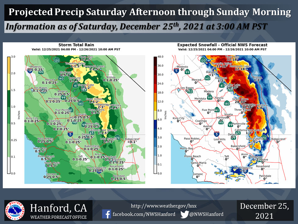
Projected Precipitation for Mariposa 0.50" - 1.00"
Projected Precipitation for Oakhurst 1.00" - 1.50"
Projected Precipitation for Yosemite Valley 1.00" - 1.50"
December 25, 2021 - The National Weather Service Hanford Office reports a storm system will impact Central California Saturday afternoon into early Sunday morning.
Snow levels will fall to around 2,000 feet in the Sierra Nevada foothills Saturday night.
Snow levels will fall to pass elevations in the Kern County mountains Saturday night.
  Area Forecast Discussion
  National Weather Service Hanford CA
  504 AM PST Sat Dec 25 2021


  .SYNOPSIS...A very wet weather pattern will continue into next
  week with brief breaks as several weather disturbances move
  across the Central California Interior. Heavy mountain snow and
  significant lower elevation rain will occur through the middle of
  next week. Snow levels will occasionally lower into the lower
  foothills and the mountain passes through Kern County.

  &&

  .DISCUSSION...
  Central California is currently experiencing a brief break from
  recent rain and high elevation snow. The next approaching low
  pressure system is pushing into the northwest coast and associated
  shower activity is currently tracking inland to the north of our
  area. Models spread these showers southward into central
  California by later this morning and periods of moderate to
  occasionally heavy rain will continue into Sunday morning.
  With a few feet of additional snowfall accumulations expected in
  the Sierra Nevada, the Winter Storm Warning continues there. This
  storm is colder than the last system and snow levels will lower
  into the foothills and several inches of snow is expected to
  accumulate there, with local amounts up to 1 foot possible through
  Sunday morning. Mountain passes in Kern county could see a few
  inches of accumulating snow as well. A Winter Weather Advisory is
  in effect for the foothills and Kern County mountain zones this
  afternoon through Sunday morning.

  Behind this system, another trough will drop out of the northeast
  Pacific and begin impacting our area by Sunday evening as rain and
  mountain snow push southward. This cold storm system will also
  drop snow levels down around 2000 ft and likely lead to
  impactful snow accumulations in the lower foothill communities
  and on the Kern mountain passes. This has prompted a Winter Storm
  Watch for the foothills and Kern County mountains Sunday evening
  through Monday night. The Winter Storm Warning in effect for the
  higher Sierra zones has meanwhile been extended through Monday
  evening in response to this next incoming system,

  After another break on Tuesday, model solutions are similar in
  showing another storm system impacting our area by the middle of
  next week. Precipitation amounts with this system are progged to
  be lower than the previous systems.


  &&


  .AVIATION...MVFR conditions are likely in and near showers over
  the next 24 hours. Mountain obscurations with areas of IFR
  conditions are expected in the Sierra Nevada through at least the
  next 24 hours.

  &&

  .AIR QUALITY ISSUES...
  None.
Source: NWS
