


Note: Cancelled on Sunday Morning
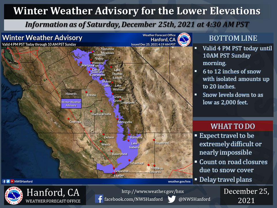
December 25, 2021 - The National Weather Service Hanford Office reports a Winter Weather Advisory is in effect for the lower Sierra Nevada, Lake Isabella, Frazier Park area, Grapevine, and Tehachapi areas from 4:00 P.M. today until 10:00 A.M. Sunday morning.
Travel will continue to be extremely difficult or impossible.
If you plan to travel, consider alternate strategies.
For information on road conditions, including closures or delays, call Caltrans at 1-800-427-7623 or Caltrans Quick Map.
Winter Weather Advisory
URGENT - WINTER WEATHER MESSAGE
National Weather Service Hanford CA
349 AM PST Sat Dec 25 2021

Mariposa-Madera Lower Sierra-Fresno-Tulare Lower Sierra-
South End of the Lower Sierra-Yosemite Valley-
San Joaquin River Canyon-Kern River Valley-Piute Walker Basin-
Tehachapi-Grapevine-Frazier Mountain Communities-
Including the cities of Bass Lake, Coarsegold, Fish Camp,
Oakhurst, North Fork, Auberry, Camp Nelson, Yosemite Valley,
Lake Isabella, Kernville, Tehachapi, Grapevine, Lebec,
and Frazier Park
349 AM PST Sat Dec 25 2021

...WINTER WEATHER ADVISORY IN EFFECT FROM 4 PM THIS AFTERNOON TO
10 AM PST SUNDAY...
...WINTER STORM WATCH IN EFFECT FROM SUNDAY AFTERNOON THROUGH
LATE MONDAY NIGHT...

* WHAT...For the Winter Weather Advisory, snow expected. Total
  snow accumulations of 6 to 12 inches possible with local amounts
  up to 20 inches. Winds gusting as high as 45 mph. For the Winter
  Storm Watch, heavy snow possible. Total snow accumulations of up
  to 30 inches possible. Winds could gust as high as 45 mph.

* WHERE...Mariposa-Madera Lower Sierra, Fresno-Tulare Lower
  Sierra, Yosemite Valley, San Joaquin River Canyon, Kern Lower
  Sierra, Kern River Valley, Piute Walker Basin, Tehachapi,
  Grapevine, Frazier Mountain Communities.

* WHEN...For the Winter Weather Advisory, from 4 PM this
  afternoon to 10 AM PST Sunday. For the Winter Storm Watch,
  from Sunday afternoon through late Monday night.

* IMPACTS...Travel could be very difficult to impossible. The
  hazardous conditions could impact the morning or evening
  commute.

* ADDITIONAL DETAILS...Snow level lowering to pass level this
  evening with a couple of inches snow accumulation possible. The
  hazardous conditions could impact the holiday weekend travel.
  Gusty winds could bring down tree branches.

PRECAUTIONARY/PREPAREDNESS ACTIONS...

If you must travel, keep an extra flashlight, food, and water in
your vehicle in case of an emergency. Monitor the latest
forecasts for updates on this situation.

The latest road conditions for the state you are calling from can
be obtained by calling 5 1 1.
Source: NWS
