


Updated at 8:20 a.m. includes new graphic
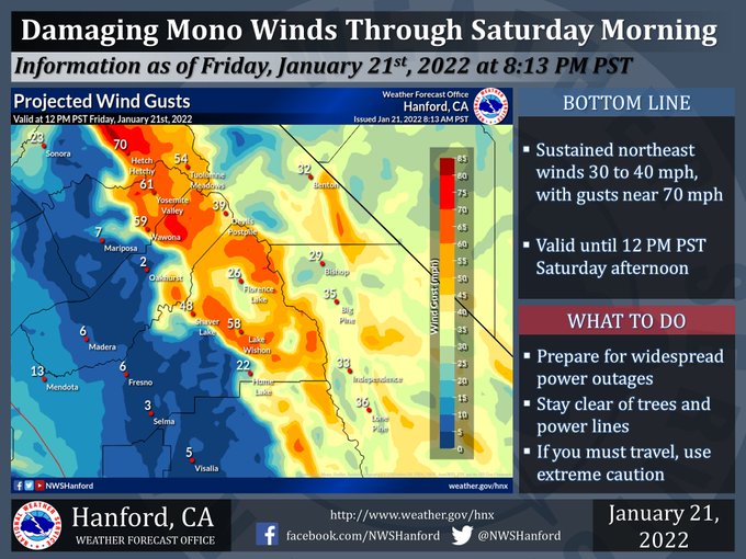
High Wind Warning for the Mariposa, Madera, and Fresno County portions of the Sierra Nevada until 12:00 P.M. Saturday afternoon. Damaging wind gusts will blow down trees and power lines. Above are projected wind gusts valid at 12:00 P.M. Friday, January 21st, 2022.
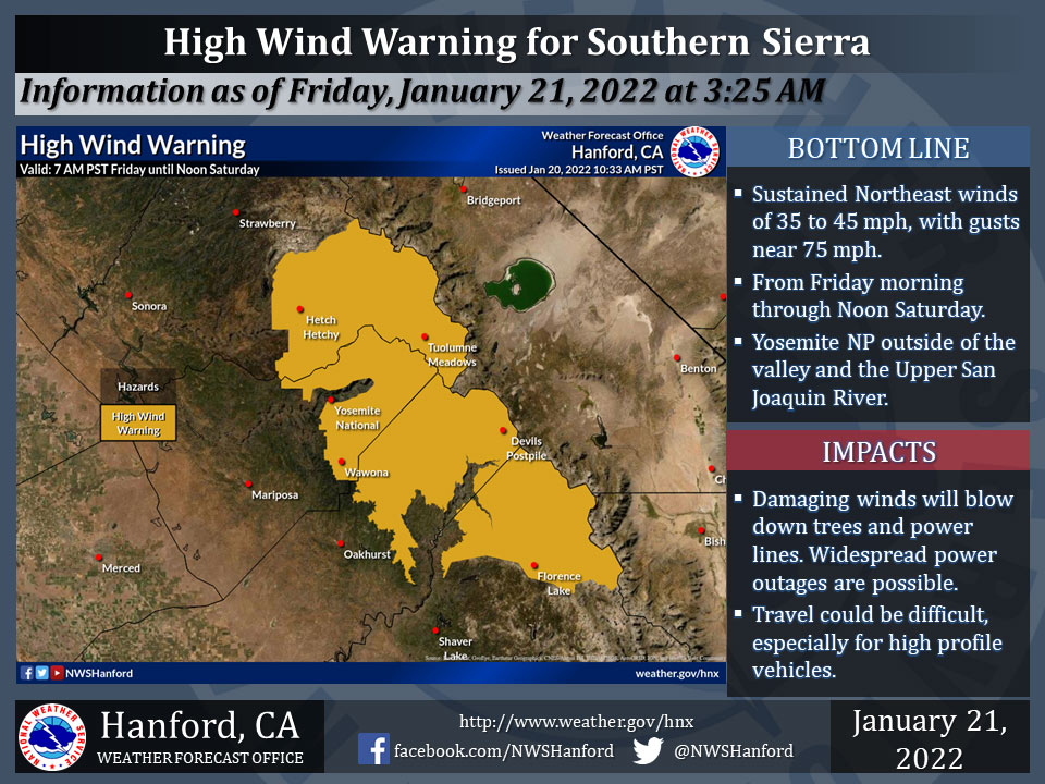
January 21, 2022 - The National Weather Service Hanford Office reports a High Wind Warning in in effect from Friday morning through Noon Saturday.
Strong wind gusts in excess of 75 mph will blow down tree branches and power lines.
Scattered power outages are likely.
Travel will be hazardous, especially for high profile vehicles.
Main area impacted will be Yosemite NP outside of the valley and across the Upper San Joaquin River.
Wind Advisory
URGENT - WEATHER MESSAGE
National Weather Service Hanford CA
439 AM PST Fri Jan 21 2022

Mariposa-Madera Lower Sierra-Yosemite Valley-
San Joaquin River Canyon-Kaiser to Rodgers Ridge-Kings Canyon NP-
Grant Grove Area-Sequoia NP-South End of the Upper Sierra-
Kern River Valley-Piute Walker Basin-Tehachapi-
Indian Wells Valley-Mojave Desert Slopes-Mojave Desert-
Including the cities of Bass Lake, Coarsegold, Fish Camp,
Oakhurst, North Fork, Yosemite Valley, Lake Wishon,
Huntington Lake, Shaver Lake, Cedar Grove, Grant Grove,
Hume Lake, Giant Forest, Lodgepole, Johnsondale, Lake Isabella,
Kernville, Tehachapi, Inyokern, Ridgecrest, Mojave, Rosamond,
California City, Randsburg, and Edwards AFB
439 AM PST Fri Jan 21 2022

...WIND ADVISORY REMAINS IN EFFECT UNTIL NOON PST SATURDAY...

* WHAT...Northeast winds 20 to 30 mph with gusts up to 55 mph
  expected.

* WHERE...Kern County mountain and desert areas, Sierra Nevada
  south of the Upper San Joaquin River, as well as the Sierra
  Nevada foothills from Mariposa to Tulare Counties.

* WHEN...From 7 AM this morning to noon PST Saturday.

* IMPACTS...Gusty winds could blow around unsecured objects.
  Tree limbs could be blown down and a few power outages may
  result.

* ADDITIONAL DETAILS...Avoid forested areas as damaging wind
  gusts will blow down trees and branches. Stay clear of power
  lines. Secure outdoor objects.

PRECAUTIONARY/PREPAREDNESS ACTIONS...

A Wind Advisory means that winds of 35 mph are expected. Winds
this strong can make driving difficult, especially for high
profile vehicles. Use extra caution.
Source: NWS
