


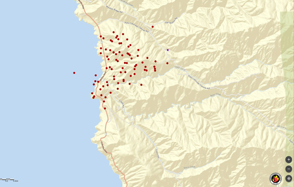
MODIS map of the Colorado Fire in Big Sur, California on Saturday Morning
Note: 1,500 Pixels Wide
MODIS Active Fire Mapping Program Frequently Asked Questions
Click here for Sunday's Information
Evening Update Per CAL FIRE: #ColoradoFire off Palo Colorado Canyon, Big Sur, south of Carmel-by-the-sea in Monterey County is at 1,050 acres, with 20% containment. Updated acreage due to better mapping. In Unified Command with CAL FIRE BEU and Mid Coast Fire.
Update 8:20 A.M. Per CAL FIRE: New Incident: #ColoradoFire off Palo Colorado Canyon, Big Sur, south of Carmel-by-the-sea in Monterey County is in the 1,500 acres range and 5% contained.
Per Caltrans District 5: Highway 1 remains closed this morning from Andrew Molera State Park in the Big Sur area to Rio Road in Carmel due to the #ColoradoFire. There is no estimate for opening. Traveler information at: Quickmap.dot.ca.gov
Per the National Weather Service:
as of 3:45 AM PST Saturday...Colorado Fire started
  last evening near Palo Colorado Rd/canyon in Big Sur. Fire has
  remained stubbornly active overnight. Pictures on social media
  suggest some pretty surreal fire behavior given the wet Oct and
  Dec that was observed across the region with multiple AR events.
  Looking at historical fire data it appears the fire is burning
  south of Palo Colorado and towards Bixby Creek along Long Ridge in
  an area with little or no fire history (the 2008 Basin, 2016
  Soberanes and 2013 Pfeiffer fire didn`t burn here and not even
  the 1977 Marble Cone or 1999 Kirk Complex). Anecdotally it seems
  as though the long term drought is acting like a chronic illness
  where even recent rains and cold winter wx isn`t helping to keep
  fires from developing.

  Looking back at last evening the fire appeared to start during the
  peak offshore winds and very low humidity. The strongest offshore
  winds have now ended in the vicinity of the Colorado Fire. As of 3
  am the current weather is showing RH values 42-52% with southerly
  winds around 5 mph. These light south winds will represent a
  potential change that residents and firefighters should monitor
  today. As these offshore wind events end (and strengthen in SoCal
  in the form of Santa Ana) we often see southerly wind reversals
  come back up the coastline. The fire is so close to the ocean that
  some locally gusty south winds could poke around Pt Sur towards
  Bixby Creek/Bridge and potentially induce the fire back towards
  Palo Colorado. Watch out for slope reversals. Winds look to turn
  back to light northeast tonight with better humidity recovery.
  Then some more light southerly winds Sunday with light offshore
  Sunday night. No rain in the forecast the next 7 days or so. Even
  a marine intrusion up Palo Colorado into the redwoods would help
  at some point early next week but too hard to pinpoint in January
  as we are not in the climatological season for marine surges. Did
  look at fuels charts and values showing near normal, which
  normally means things dont actively burn in January.
