


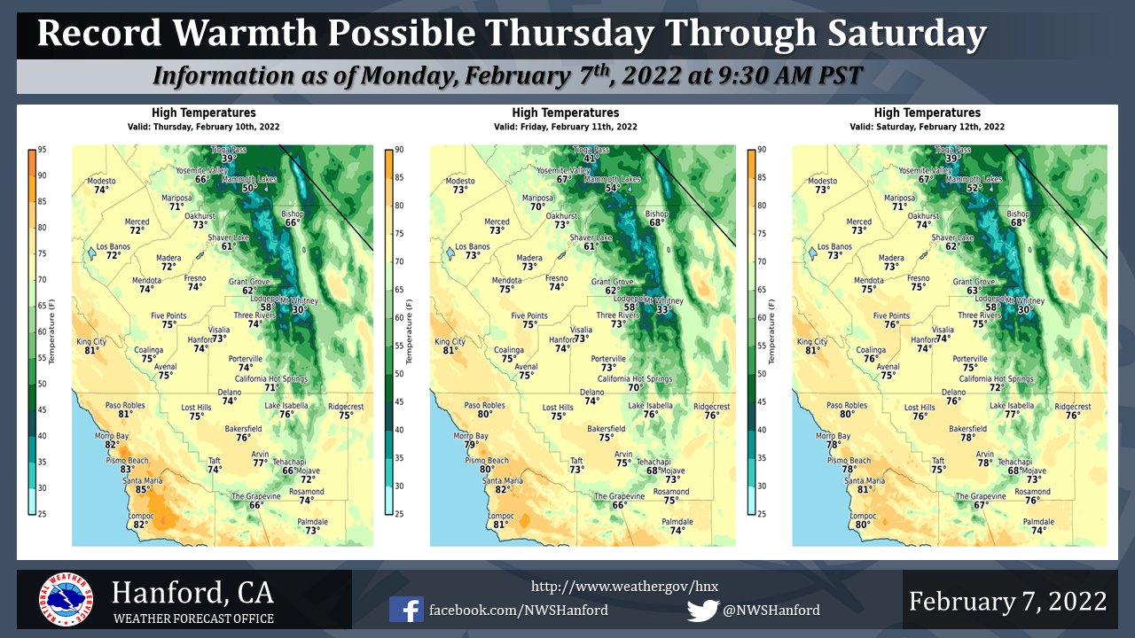
Mariposa Projected High Temperatures for Thursday, Friday and Saturday Range from 70-71 Degrees
Oakhurst Projected High Temperatures for Thursday, Friday and Saturday Range from 73-74 Degrees
Yosemite Valley Projected High Temperatures for Thursday, Friday and Saturday Range from 66-67 Degrees
February 7, 2022 - The National Weather Service Hanford Office reports high temperatures throughout Central California Thursday afternoon, Friday afternoon, and Saturday afternoon will be twelve to fourteen degrees above normal for this time of year.
Record warmth is possible in parts of the San Joaquin Valley.
  Area Forecast Discussion
  National Weather Service Hanford CA
  255 AM PST Mon Feb 7 2022


  .SYNOPSIS...
  High temperatures each afternoon through Wednesday will be around
  ten degrees above normal for this time of year. Maximum
  temperatures each afternoon Thursday through Sunday will be twelve
  to fourteen degrees above their typical values for the first half
  of February. Dry weather will persist through at least the next
  seven days.

  &&

  .DISCUSSION...
  Surface observations and satellite imagery showing a clear
  picture that a high pressure ridge is in control of the West
  Coast. While over low temperatures will continue to bottom out in
  the 30s (based on the regions dry air-mass), afternoon highs will
  progress further toward the 70s this week. Moreover, with cold air
  over the Great Basin, the orientation of the surface pressure
  gradient is providing for an easterly (offshore) wind which will
  help with areas temperatures. Even with a surface pressure
  gradient from KSFO to KLAS of about negative 4mb, will not expect
  winds to increase beyond a light breeze this afternoon. At this
  point, with probabilistic forecast all pointing in the direction
  of a blocking high over the West, can record high temperatures be
  reaching.

  Ensemble confidence has almost max-out toward the development of
  the strong ridge pattern over the West Coast this week. While
  temperature prognosis still show the possibility of reaching into
  the mid 30s, the probability of exceedance for temperatures below
  32 is dropping well below 30 percent as mid to upper 30s are now
  more likely. The to other side of the equation, probability of
  exceedance for temperatures of 70 degrees is still above the 60
  percent mark before mid-week. While isolated spots could reach the
  70 degree mark this Monday and Tuesday, afternoon high on
  Wednesday show a high probability of showing widespread 70s.
  Therefore, will maintain the trend of reaching the 70 degree mark
  this week under a strong blocking high pattern.

  Ensemble analysis still showing the ridge pattern persisting
  during the period through the weekend and into early next week.
  Unfortunately, this pattern will provide the area with no real
  chances of significant precipitation. Predictability and Cluster
  analysis both show a rather strong signal toward maintaining the
  ridge pattern in place during the extended period. Therefore, will
  expect to see dry conditions for the coming week and into the
  weekend.

  &&

  .AVIATION...
  In the San Joaquin Valley, intermittent MVFR visibilities are
  likely due to haze and mist. Otherwise, VFR conditions will
  prevail throughout Central California today through at least
  Monday morning.

  &&

  .AIR QUALITY ISSUES...
  On Monday February 7 2022...Fireplace/Wood Stove Burning Status
  is: No Burning Unless Registered in Fresno, Kern, Kings, Madera,
  Merced and Tulare Counties. Further information is available at
  Valleyair.org
Source: NWS
