


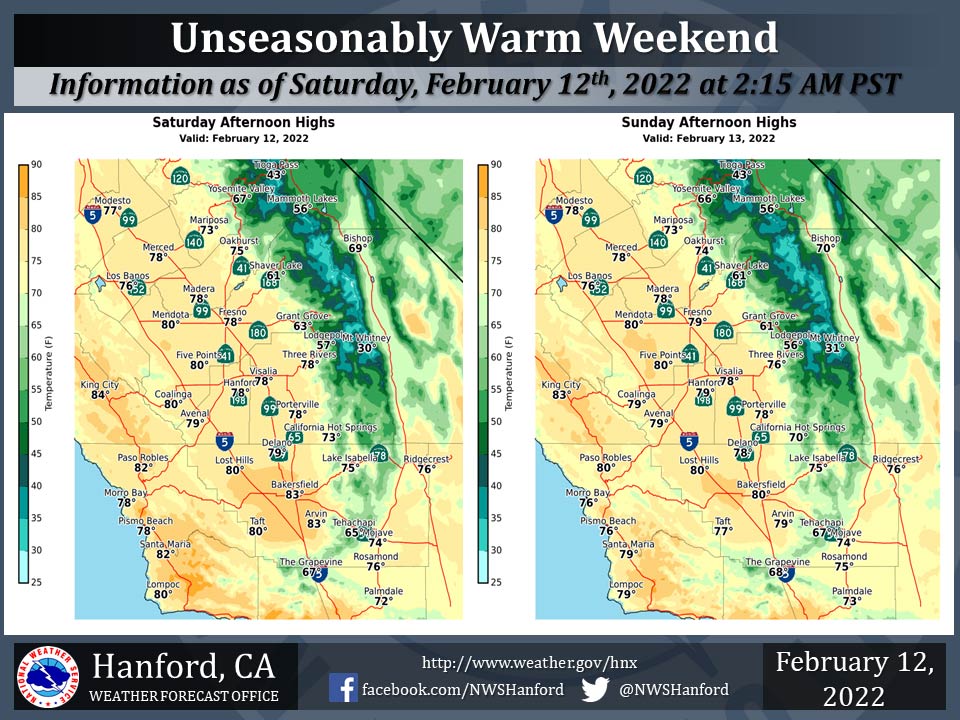
Mariposa Projected High Temperatures for Saturday-Sunday: 73 Degrees
Oakhurst Projected High Temperatures for Saturday-Sunday Range from 74-75 Degrees
Yosemite Valley Projected High Temperatures for Saturday-Sunday Range from 66-67 Degrees
February 12, 2022 - The National Weather Service Hanford Office reports high temperatures across the area will be 15 to 20 degrees above normal for this time of year today and Sunday.
Several new daily record highs are possible.
  Area Forecast Discussion
  National Weather Service Hanford CA
  1244 AM PST Sat Feb 12 2022

  .SYNOPSIS...
  Record warmth is expected throughout the San Joaquin Valley this
  afternoon. Record warmth is anticipated in most of the San Joaquin
  Valley Sunday afternoon. Record warmth is likely in parts of the
  San Joaquin Valley Monday afternoon. Much cooler weather, along
  with a chance of mountain precipitation, is expected late Monday
  night and Tuesday.

  &&

  .DISCUSSION...
  A ridge of high pressure will remain parked over California this
  weekend. This ridge of high pressure will finally translate
  eastward Monday. High temperatures throughout Central California
  this afternoon will be seventeen to nineteen degrees above normal
  for this time of year. Record warmth is expected this afternoon
  in Madera (92% probability), Merced (91% probability), Fresno (89%
  probability), Bakersfield (85% probability), and Hanford (84%
  probability). Maximum temperatures across Central California Sunday
  afternoon will be sixteen to eighteen degrees above their typical
  values for the middle of February. Record warmth is expected
  Sunday afternoon in Merced (79% probability), Madera (77%
  probability), and Fresno (70% probability). High temperatures
  throughout Central California Monday afternoon will be eleven to
  thirteen degrees above normal for this time of year. Record warmth
  is likely Monday afternoon in Madera (62% probability) and Merced
  (57% probability). Record warmth is possible Monday afternoon in
  Bakersfield (29% probability).

  A cold front will move southward through the forecast area late
  Monday night into Tuesday. Maximum temperatures across Central
  California Tuesday afternoon will be around fifteen degrees cooler
  than Monday afternoon. Although most precipitation associated
  with the aforementioned cold front will be confined to the Sierra
  Nevada and Kern County mountains, there is a slight chance of
  showers in the eastern and southern portions of the San Joaquin
  Valley Tuesday. Rain amounts, if any, will be well below one tenth
  of an inch. The snow level will start at around 6,000 feet Monday
  night, before falling to about 4,000 feet Tuesday afternoon. Snow
  amounts should be an inch or less from 4,000 feet to 6,000 feet,
  one to two inches from 6,000 feet to 7,000 feet, and two to four
  inches above 7,000 feet. West to northwest wind gusts near 50 mph
  are possible in the Kern County mountains and desert Tuesday
  afternoon into Tuesday evening. A Wind Advisory may be required
  for the Kern County mountains and desert during this time frame.

  A ridge of high pressure will move slowly eastward across the
  Eastern Pacific Ocean Wednesday through Friday. This ridge of high
  pressure should make landfall over California next weekend. A
  warming trend is expected Wednesday through Friday. By Friday
  afternoon, high temperatures in Central California will be seven
  to nine degrees above normal for this time of year.

  &&

  .AVIATION...
  MVFR visibilities, with localized IFR visibilities, are likely in
  the San Joaquin Valley due to mist and haze this morning. VFR
  conditions will prevail throughout Central California this
  afternoon. MVFR visibilities, with localized IFR visibilities, are
  possible in the San Joaquin Valley due to mist and haze tonight.

  &&

  .AIR QUALITY ISSUES...
  On Saturday, February 12th, 2022, unhealthy for sensitive groups
  in Fresno and Kern Counties. Fireplace/wood stove burning status
  is: no burning unless registered in Kings, Madera, Merced, and
  Tulare Counties. No burning for all in Fresno and Kern Counties.
  Further information is available at Valleyair.org.
Source: NWS
