


February 13, 2022 - The National Weather Service Hanford Office reports light snow is possible in the Sierra Nevada late Monday night and Tuesday.
The snow level will start at around 6,000 feet Monday night, before falling to about 4,000 feet Tuesday morning.
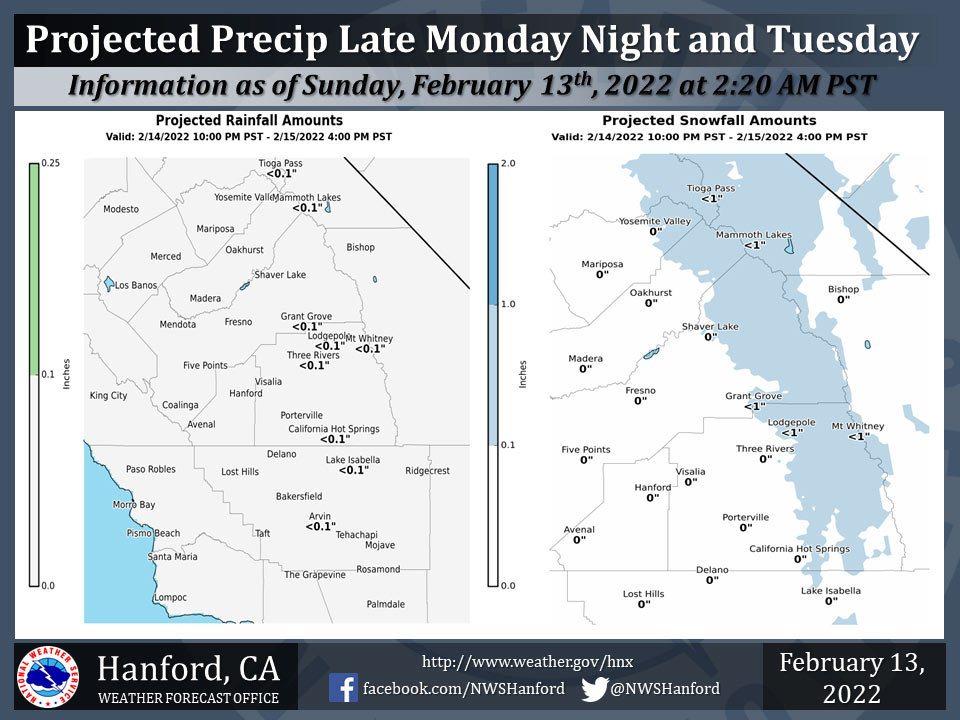
Snow amounts will be an inch or less.
There is a slight chance of light rain in the Sierra Nevada foothills late Monday night and Tuesday.
Dry weather will persist in the San Joaquin Valley.
  Area Forecast Discussion
  National Weather Service Hanford CA
  238 AM PST Sun Feb 13 2022

  .SYNOPSIS...Strong high pressure will remain over the area
  through Monday with record or near record heat. A cold low
  pressure system will then move southward through the Great Basin
  Monday night and Tuesday bringing much cooler temepratures,
  increased winds and a slight chance of light precipitation. High
  pressure will build inland later in the week for a return warmer
  than normal temperatures and dry conditions.

  &&

  .DISCUSSION...A large area of strong high pressure is maintaining
  an unseasonably warm airmass over our region and as a result,
  several new daily record maximum temperatures were set on
  Saturday across the area. With the high remaining dominant today,
  another day of near record highs are expected across our area.
  Latest NBM probabilistic guidance indicates that Fresno has a 77
  percent chance of reaching or exceeding it/s previous record for
  today (79 Deg F in 1921) and Bakersfield has a 16 percent chance
  of reaching or exceeding it/s previous record for today (83 Deg F
  in 1924).

  SREF indicating that the large high will break down as a cold low
  pressure system drops out of the Gulf of AK tonight and into the
  PAC NW on Monday. However, with the unseasonably warm airmass
  still prevalent over our area, temperatures will remain well above
  seasonal normals on Monday. The low will then drop southeast
  through the Great Basin on Tuesday with the main impacts for our
  area being increased winds on Tuesday afternoon and evening most
  noticably over the mountains and Kern County Deserts where winds
  could gust near 50 mph along the Mojave Desert Slopes as well as
  much cooler temperatures as Tuesday`s highs are expected to be
  close to seasonal normals which is 15-20 Deg F below today`s
  readings.

  Blended guidance has been trending lower with precipitation
  amounts from this system, with up to a tenth of an inch of liquid
  precipitation possible in the mountains with much of the remainder
  of our area remaining dry as this system is progged to be
  moisture deficient. Snow levels are progged to be between 3500 and
  4500 feet on Tuesday afternoon so up to an inch of new snowfall
  is possible over the higher elevations.

  The low is progged to move well to the east of our area on
  Wednesday as a large dry upper ridge amplifies just off the CA
  coast. Ensemble means show the ridge building inland Thursday
  through Saturday which will provide for daytime temperatures
  rising back up to much above normal levels for this period.
  Another low pressure system is progged to impact our area by the
  end of next weekend which will bring cooler temperatures and
  possibly some precipitation to our area by next Sunday night, but
  there is still some uncertainty dealing with it`s track and it`s
  timing.

  &&

  .AVIATION...In the San Joaquin Valley, areas of MVFR visibility,
  with local IFR visibility due to mist and haze through 18Z Sun
  and again after 08Z Mon. Otherwise, VFR conditions will prevail
  throughout the central CA interior for the next 24 hours.

  &&

  .AIR QUALITY ISSUES...On Sunday February 13 2022... Unhealthy for
  sensitive groups in Fresno... Kern and Kings Counties.
  Fireplace/Wood Stove Burning Status is: No Burning Unless
  Registered in Kings... Madera and Tulare Counties. No Burning For
  All in Fresno and Kern Counties. Further information is available
  at Valleyair.org
Source: NWS
