


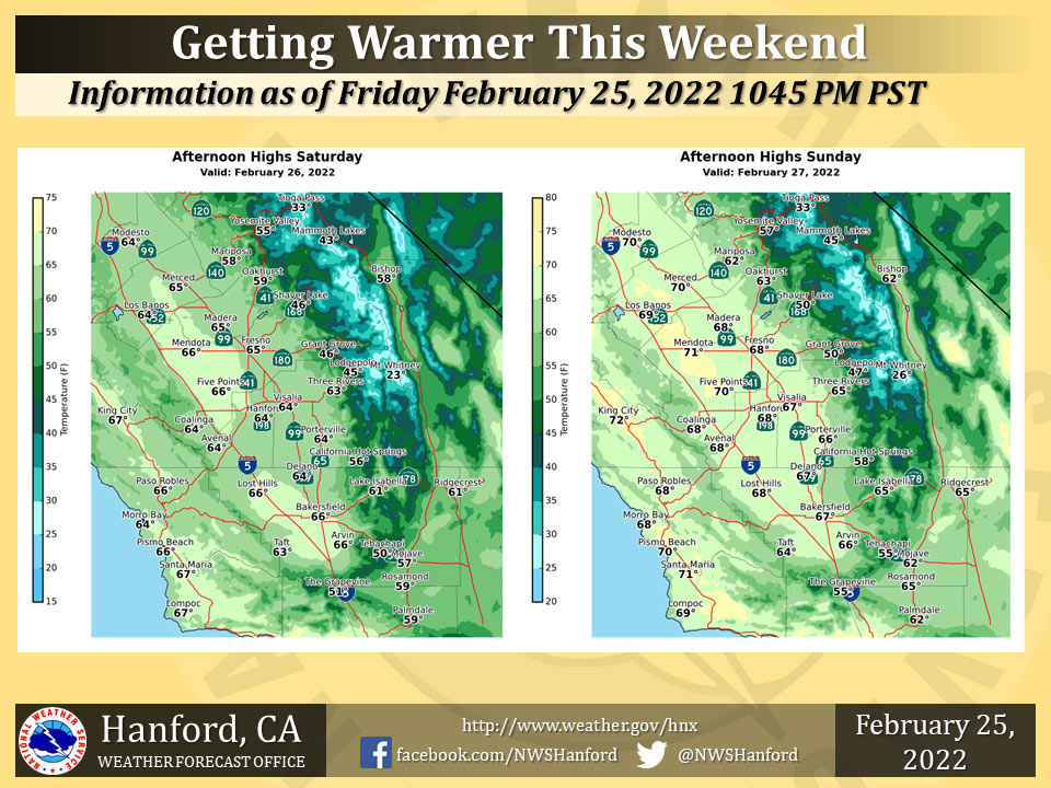
Mariposa Projected High Temp for Saturday: 58 Degrees, Sunday: 62 Degrees
Oakhurst Projected High Temp for Saturday: 59 Degrees, Sunday: 63 Degrees
Yosemite Valley Projected High Temp for Saturday: 55 Degrees, Sunday: 57 Degrees
February 26, 2022 - The National Weather Service Hanford Office reports temperatures will generally range in the mid to upper 60s across the San Joaquin Valley this weekend.
Seasonal normal high temperatures are in the mid 60s.
  Area Forecast Discussion
  National Weather Service Hanford CA
  212 AM PST Sat Feb 26 2022

  .SYNOPSIS...Widespread freezing temperatures will occur again
  in the San Joaquin Valley this morning. A slow warmup begins by
  Sunday as temperatures gradually increase back to seasonably
  normal values the to above normal levels for Monday through
  Wednesday. A weak system will bring cooler temperatures along
  with a chance for precipitation to much of the area on Thursday.

  &&

  .DISCUSSION...Northerly flow aloft continues over our area as we
  are currently situated in between an upper ridge just off the CA
  coast and a trough over the Great Basin. With clear skies and
  light surface winds prevailing over our area once again
  radiational cooling will provide for another frosty morning across
  the San Joaquin Valley although temperatures are currently running
  1-3 Deg F above yday at this time. This should be the last night
  with widespread sub-freezing temepratures in the San Joaquin
  Valley as SREF is indicating the offshore ridge builds inland
  today resulting in rises in heights and thicknesses, and a storm
  riding over the ridge pushes into the PAC NW tonight and Sunday
  spreading mid/high clouds into our area which will partially limit
  radiational cooling. Latest NBM probabilistic guidance indicates
  the chance of subfreezing temperatures in most of the San Joaquin
  Valley on Sunday morning is 2 percent or less.

  With the ridge shifting inland on Sunday, a southwest flow aloft
  will become established over central CA. This will result in a
  warming trend over our area Sunday through Wednesday with daytime
  temperatures rising to slightly above seasonal normals on Sunday
  trending upward each day through Wednesday. Dry weather will
  prevail across our area through Wednesday although storms moving
  through the PAC NW will bring some mid/high clouds to our area.

  The medium range ensemble means are trending a further northward
  track with a system which might impact our area on Wednesday
  night and Thursday. There is still some spread amongst the
  ensemble members with this system, but the latest NBM
  probabilistic guidance is now indicating just a 25 percent chance
  of measurable precipitation for Yosemite Valley on Thursday with
  most of the San Joaquin valley north of Kern County having a 15
  to 20 percent chance of measurable rain on Thursday. Guidance is
  continuing to show that temperatures are progged to cool to near
  seasonal normals for Thursday and Friday.

  &&

  .AVIATION...VFR conditions will prevail throughout the Central
  CA interior for the next 24 hours.

  &&

  .AIR QUALITY ISSUES...On Saturday February 26 2022...
  Fireplace/Wood Stove Burning Status is: No Burning Unless
  Registered in Fresno... Kern... Kings... Madera and Tulare
  Counties. Further information is available at Valleyair.org
Source: NWS
