


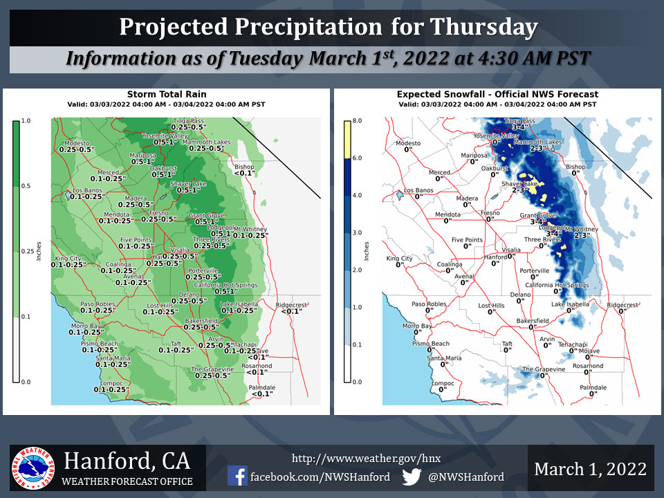
Projected Precipitation for Mariposa 0.50" to 1.00"
Projected Precipitation for Oakhurst 0.50" to 1.00"
Projected Precipitation for Yosemite Valley 0.50" to 1.00"
March 1, 2022 - The National Weather Service Hanford Office: Here are the latest forecast precipitation graphics for the period from Thursday morning until Friday morning.
The majority of this precipitation will fall Thursday afternoon and evening.
Snow levels will start at around 6,000 feet during the day on Thursday and fall to near 4000 feet by Friday morning.
  Area Forecast Discussion
  National Weather Service Hanford CA
  315 AM PST Tue Mar 1 2022


  .SYNOPSIS...
  A warming trend will continue for the next couple of days, with
  temperatures well above seasonable normals. A weather system will
  bring cooler temperatures for the latter half of the week, along
  with a chance for precipitation Thursday into the weekend.

  &&

  .DISCUSSION...
  Warm and dry trend continues today as the region observes above
  seasonal normal temperatures. While some high clouds will be
  observed today from a storm pushing through the Pacific Northwest,
  these clouds will do little to slow down todays warming. The
  ridge responsible for the current warming trend will hold over the
  region through at least the middle of the week. During that time,
  temperatures cloud reach about 10 to 15 degrees above seasonal
  normal values. Yet, change is on the way as a storm system drops
  from the Gulf of Alaska later this week.

  A change in the weather will be ushered into the region starting
  near the Thursday morning period and continuing into Friday.
  Ensembles analysis in both the realm of predictability and
  clusters show very high confidence in the transition to unsettled
  conditions near the Thursday time frame. In the short term,
  satellite water vapor and upper-air analysis show the progression
  of an Atmospheric River (AR) as it travels through the Pacific
  Northwest. While moisture from this AR will shift south toward the
  Central California area later in the week, the magnitude of its
  moisture will be much less then that needed for a full AR.
  Therefore, with no continued feed from the subtropics by Thursday,
  will see just enough moisture entering the region for light to
  moderate precipitation rates. Current projections of precipitation
  accumulation show the valley receiving between a quarter to a
  half inch through Friday afternoon. The foothills and Sierra
  Nevada could receive up to an inch of water equivalent liquid due
  to orographic enhancement for the same time frame.

  Ensembles (and cluster analysis) suggest a return to colder
  temperatures toward the end of the week and int the weekend.
  However, upper-air ensemble analysis is not projecting to return
  of below freezing temperatures. Due to the trajectory of the next
  storm, Central California may not be favor for a full AR event,
  yet, confidence in higher for probability of measurable
  precipitation.

  Any precipitation will be good news. Hopefully, ensemble
  continues in the direction of precipitation for Central
  California. Ensemble do not hint toward the return of the West
  Coast Ridge until closer to the day seven period. Therefore,
  hopefully the period of unsettled weather may be extended into the
  weekend for even more precipitation during the latter parts of
  the forecast period. Again, any additional would be a benefit to
  the region.

  &&

  .AVIATION...
  VFR conditions will prevail throughout the Central CA Interior
  for the next 24 hours.

  &&

  .AIR QUALITY ISSUES...
  None.
Source: NWS
