


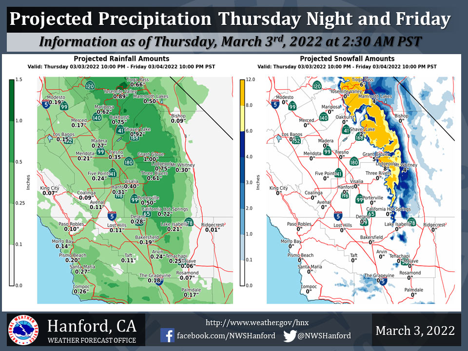
Projected Precipitation for Mariposa 0.62"
Projected Precipitation for Oakhurst 0.75"
Projected Precipitation for Yosemite Valley 0.89"
March 3, 2022 - The National Weather Service Hanford Office reports a low pressure system will move eastward across Southern California Thursday night and Friday.
The majority of precipitation associated with this storm system will fall late Thursday night and Friday.
The snow level will start at around 7,000 feet Thursday night, before dropping to about 6,000 feet Friday morning.
  Area Forecast Discussion
  National Weather Service Hanford CA
  1248 AM PST Thu Mar 3 2022

  .SYNOPSIS...
  A storm system will move eastward across Southern California
  tonight and Friday, resulting in precipitation throughout most of
  the service area. A second, colder storm system will progress
  southward down the California/Nevada border Friday night and
  Saturday. This storm system will be responsible for lower
  elevation snow.

  &&

  .DISCUSSION...
  An upper-level area of low pressure will approach the coast of
  Southern California today. High temperatures this afternoon will
  be around five degrees above normal for this time of year. The
  aforementioned area of low pressure aloft will progress eastward
  across Southern California tonight and Friday. Precipitation
  associated with this storm system will spread northward into
  Central California after midnight tonight. The snow level will
  start at around 6,000 feet tonight, before falling to about 5,000
  feet Friday morning. Four to eight inches of snow is expected
  above 5,000 feet late tonight through Friday evening. One tenth of
  an inch to one quarter of an inch of rain is likely in the San
  Joaquin Valley late tonight through Friday evening. One quarter of
  an inch to one half of an inch of rain is anticipated in the
  Sierra Nevada foothills. Less than one tenth of an inch or rain is
  expected in the Coastal Hills and Kern County desert. Westerly
  wind gusts near 55 mph are possible in the Mojave Desert Slopes
  Friday afternoon and Friday evening.

  A colder storm system will move southward down the
  California/Nevada border Friday night and Saturday. Snow levels
  will start at around 3,000 feet Friday night, before falling to
  around 1,500 feet Saturday morning. In the Sierra Nevada
  foothills, an inch or less of snow is likely from 1,500 feet to
  4,000 feet Friday night through Saturday afternoon. One to three
  inches of snow is possible in the Sierra Nevada from 4,000 feet
  to 5,000 feet Friday night through Saturday evening. Three to six
  inches of snow is conceivable in the Sierra Nevada above 5,000
  feet Friday night through Saturday evening. Rain amounts should
  remain under one tenth of an inch in the San Joaquin Valley Friday
  night through Saturday afternoon. Light snow is likely along
  Interstate 5 over Tejon Pass and along Highway 58 over Tehachapi
  Pass from about 4 AM PST early Saturday morning until 4 PM PST
  Saturday afternoon. The probability of a trace of snow ore more in
  Tehachapi is 74% and the probability of a trace of snow ore more at
  Tejon Pass is 65%. The probability of one inch of snow or more in
  Tehachapi is 37% and the probability of one inch of snow ore more
  at Tejon Pass is 21%. Finally, strong, gusty west to northwest
  winds are possible in a portion of the Kern County mountains and
  desert Saturday afternoon into early Saturday night.

  Gradually warming is expected Sunday through Wednesday as a
  Eastern Pacific ridge of high pressure remains just offshore of
  the west coast of the United States. High temperatures will
  increase by about five degrees each afternoon Sunday through
  Tuesday. By Wednesday afternoon, maximum temperatures in Central
  California will be two to four degrees above their typical values
  for the first half of March.

  &&

  .AVIATION...
  VFR conditions will prevail today into tonight. MVFR or lower
  conditions are possible after 09z tonight as precipitation spreads
  northward over Central California.

  &&

  .AIR QUALITY ISSUES...
  None.
Source: NWS
