


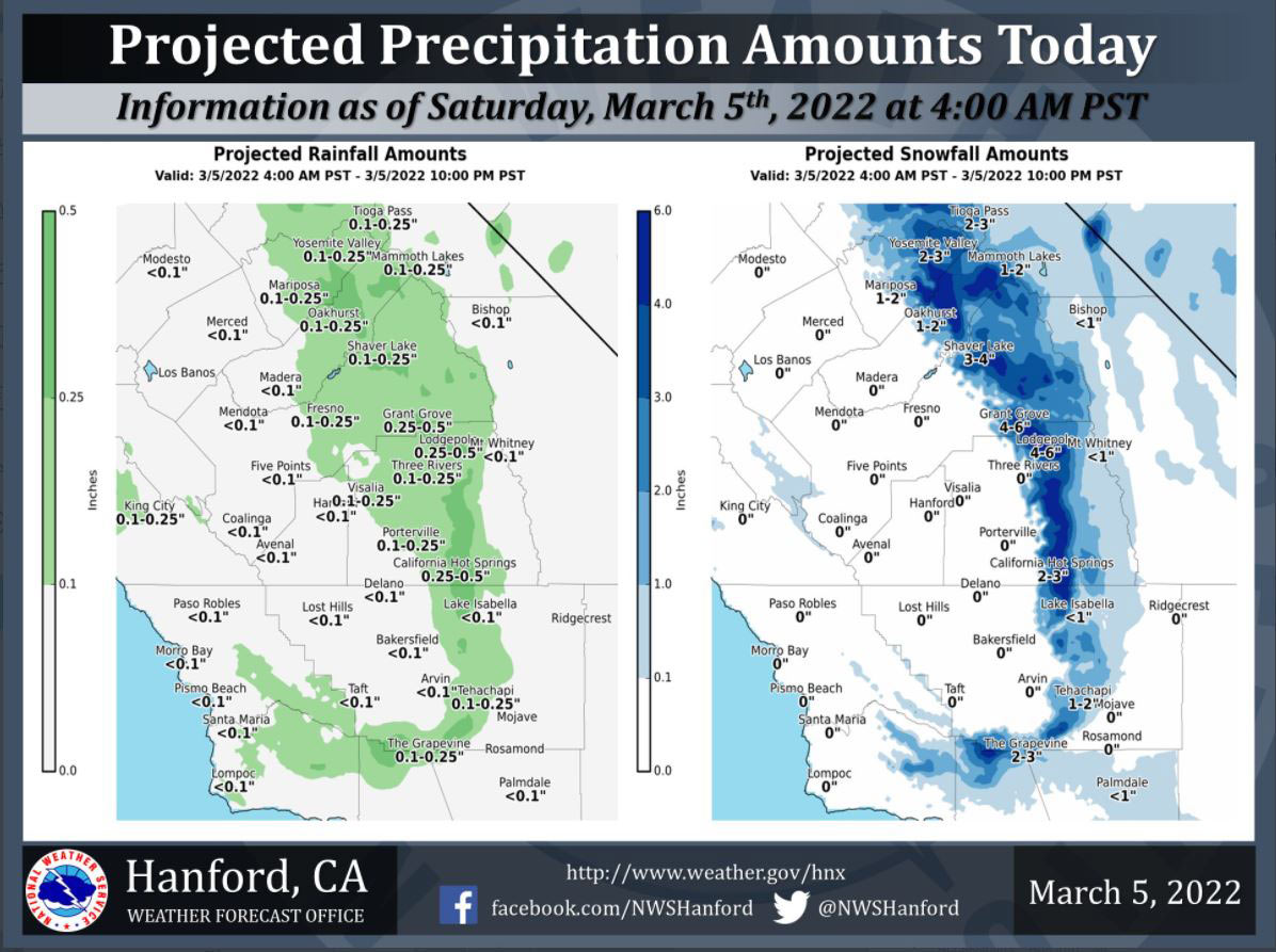
Projected Precipitation for Mariposa 0.10-0.25"
Projected Precipitation for Oakhurst 0.10"-0.25"
Projected Precipitation for Yosemite Valley 0.10-0.25"
March 5, 2022 - The National Weather Service Hanford Office reports a storm system is moving southward down the California/Nevada border this morning.
The majority of precipitation associated with this storm system will fall this morning.
The snow level will start at around 3,000 feet this morning and slowly rise to 5000 feet just before sunset today.
Accumulating snow is likely along Highway 58 over Tehachapi and Interstate 5 over Tejon Pass today.
Travel delays and/or road closures are possible. If you plan to travel, consider alternate strategies. If you must travel, allow plenty of time to reach your destination.
  National Weather Service Hanford CA
  115 AM PST Sat Mar 5 2022

  .SYNOPSIS...
  A storm system will move southward down the California/Nevada
  border today. This storm system will be responsible for low
  elevation snow and mainly light rain in the San Joaquin Valley.
  Strong, gusty west winds will persist in the Kern County desert
  today into tonight. A gradual warming trend is expected Sunday
  through Wednesday.

  &&

  .DISCUSSION...
  A low pressure system will move southward down the
  California/Nevada border today. This storm system will slide
  eastward into the Great Basin tonight. The main weather concern
  today will be accumulating snow over Kern County mountain passes.
  Two to three inches of snow is likely along Interstate 5 over
  Tejon Pass from 7 AM PST this morning until 10 PM PST this
  evening. The probability of two inches of snow or more at Tejon
  Pass is 64 percent. One to two inches of snow is probable along
  Highway 58 over Tehachapi Pass from 7 AM PST this morning until 10
  PM PST this evening. Travel delays and/or road closures are
  possible. Plan accordingly.

  In the Sierra Nevada, four to six inches of snow is expected above
  6,000 feet today. Two to four inches of snow is anticipated from
  4,000 feet to 6,000 feet today. In the Sierra Nevada foothills,
  one to two inches of snow is expected above 1,500 feet today. In
  the San Joaquin Valley, rain amounts should be one tenth of an
  inch or less. The exception could be the extreme eastern portion
  of the San Joaquin Valley where rain amounts could be between one
  tenth of an inch and one quarter of an inch. West wind gusts near
  55 mph are likely in the Kern County desert today into tonight.

  A warming trend is anticipated Sunday through Wednesday as an
  Eastern Pacific ridge of high pressure remains offshore of the
  west coast of the United States. High temperatures each afternoon
  Sunday through Tuesday should be around five degrees warmer than
  the previous day. By Wednesday afternoon, maximum temperatures
  will be a couple of degrees above normal for this time of year.
  Temperatures should remain just above seasonal values Thursday and
  Friday as the aforementioned ridge of high pressure begins to
  progress eastward.

  &&

  .AVIATION...
  Widespread mountain obscuring IFR will prevail in snow showers
  over the Sierra Nevada, adjacent foothills, and Kern County
  mountains today into early tonight. Short-lived, MVFR conditions
  are likely in and near showers in the San Joaquin Valley and
  Coastal Range today.

  &&

  .AIR QUALITY ISSUES...
  None.
Source: NWS
