


Mariposa projected high temp for Tuesday: 59 degrees
Oakhurst projected high temp for Tuesday: 61 degrees
Yosemite Valley projected high temp for Tuesday: 57 degrees
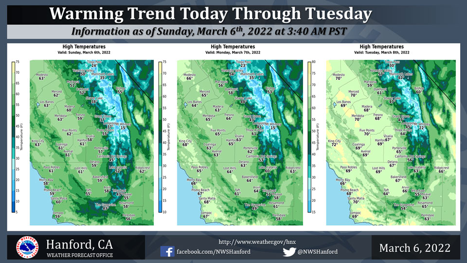
March 6, 2022 - The National Weather Service Hanford Office reports high temperatures this afternoon will be around five degrees warmer than yesterday.
Maximum temperatures Monday afternoon will be about five degrees warmer than this afternoon.
By Tuesday afternoon, high temperatures will be near normal for this time of year
  Area Forecast Discussion
  National Weather Service Hanford CA
  250 AM PST Sun Mar 6 2022


  .SYNOPSIS...
  Dry and mild conditions will be in store for next week, with
  temperatures rising to a few degrees above normal by midweek.

  &&

  .DISCUSSION...
  The second of two storms is finally exiting the region with
  lingering clouds banking up on the south and eastern side of the
  San Joaquin Valley. Other than the cloud bank along the foothills
  and the south end of the valley, will expect mostly sunny skies
  across most of the district today. The cold air-mass from the
  second storm is now entrenched over Central California as near
  freezing conditions will be observed this morning  as well as
  that of Monday morning. The cold air continues to push south and
  is filtering into the Mojave Desert. While the surface pressure
  gradient from KSFO to KLAS is still around 8mb, the trend is to
  continue relaxing the gradient as more cold air reaches into the
  desert. Therefore, allowed the Wind Advisory to expire this
  morning as the breezy winds diminish to light winds after sunrise.
  While the district will begin drying out during the next few
  days, a cyclonic flow pattern will exist over the West Coast that
  will limit the amount of warming for most of the week. Ridging
  will not dominate the region until next weekend.

  NBM point analysis along with instability analysis show clouds
  lingering over the higher terrain today. While most of the valley
  will remain clear, the south end near Bakersfield will see cloud
  through at least sunset this Sunday. Probabilistic cloud cover and
  instability analysis show the West Coast becoming very stable on
  Monday as Clear Skies are expected to dominate the Central
  California Interior. Even with the sunshine, a northerly flow
  aloft over the region will prevent any strong warm-ups. Therefore,
  slow heating will occur for most of the week and Central
  California stays near seasonal normal values. Ensemble Cluster
  Analysis is showing no strong signal toward a rapid warm-up with
  stronger confidence in the cooler temperature solution. Even-more,
  Probabilistic Minimum temperatures Index values point toward very
  cold night through Monday. The index will add value toward the
  cold temperature solution as near freezing may be observed for the
  next two mornings. As mentioned before, winds are diminishing.
  Yet, the cyclonic flow may allow for one more piece of energy to
  cut across the district on Monday for a brief increase in Desert
  winds.

  Approaching days six and seven, uncertainty in the possible
  solution increases, but, does lean toward a ridge axis over the
  West Coast. Currently, most of the uncertainty lies in the timing
  of the ridges approach onto the West Coast. If the ridge is slowed
  by the exiting disturbance moving through the Midwest, the ridge
  may have to wait to provide significant warming. Therefore, even
  going into the weekend, dry conditions will be accompanied by
  warming that is less the ten degrees from their seasonal normal.

  &&

  .AVIATION...
  Areas of mountain obscuring IFR will prevail in lingering snow
  showers over the Sierra Nevada, adjacent foothills, and Kern
  County mountains through 06Z Sunday. Westerly wind gusts up to 55
  mph are possible across the Kern County mountains and desert
  through 08Z Sunday.

  Otherwise, expect mainly VFR conditions over the Central
  California Interior for at least the next 24 hours.

  &&

  .AIR QUALITY ISSUES...
  None.
Source: NWS
