


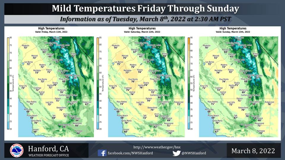
Mariposa Projected High Temp for Friday: 63 Degrees, Saturday: 67 Degrees, Sunday: 64 Degrees
Oakhurst Projected High Temp for Friday: 65 Degrees, Saturday: 67 Degrees, Sunday: 65 Degrees
Yosemite Valley Projected High Temp for Friday: 59 Degrees, Saturday: 62 Degrees, Sunday: 59 Degrees
March 8, 2022 - The National Weather Service Hanford Office reports high temperatures throughout Central California Friday afternoon will be three to five degrees above normal for this time of year.
Maximum temperatures across Central California Saturday afternoon will be five to seven degrees above their typical values for the first half of March.
High temperatures throughout Central California Sunday afternoon will be three to five degrees above normal for this time of year.
  Area Forecast Discussion
  National Weather Service Hanford CA
  1249 AM PST Tue Mar 8 2022

  .SYNOPSIS...
  A warming trend is expected today and Wednesday. Strong, gusty
  west winds are conceivable in the Kern County desert Wednesday
  afternoon and Wednesday evening ahead of an atmospheric
  disturbance. This atmospheric disturbance should brush the
  eastern portion of the forecast area Wednesday night and Thursday,
  resulting in the possibility of mountain snow showers.

  &&

  .DISCUSSION...
  An anticyclone aloft will be centered over the Eastern Pacific
  Ocean, just offshore of California today and tonight. A trough of
  low pressure will drop southward from Canada into the Pacific
  Northwest Wednesday. A warming trend is anticipated today and
  Wednesday. High temperatures this afternoon will be around five
  degrees warmer than yesterday. Maximum temperatures Wednesday
  afternoon will be a couple of degrees above normal for this time
  of year. Strong, gusty west winds are possible in the Kern County
  desert Wednesday afternoon and Wednesday evening. A Wind Advisory
  may be required for the Kern County desert Wednesday afternoon and
  Wednesday evening.

  The aforementioned trough of low pressure will progress southward
  over Nevada Wednesday night and Thursday. This will lead to the
  possibility of snow showers in the Sierra Nevada and Kern County
  mountains Wednesday night and Thursday. Snow levels will start at
  around 5,000 feet Wednesday night, before falling to around 3,000
  feet Thursday. Snow amounts will generally be an inch or less,
  with a chance of one to two inches along the Sierra Nevada crest.
  High temperatures Thursday afternoon will be around five degrees
  cooler than Wednesday afternoon.

  A ridge of high pressure will move eastward over the Eastern
  Pacific Ocean Thursday night. This ridge of high pressure will
  make landfall over the west coast of the United States Friday. The
  ridge of high pressure will progress eastward over California
  Friday night, before entering the Great Basin Saturday. A rather
  weak trough of low pressure may move eastward across Central
  California Saturday night or Sunday. This feeble atmospheric
  disturbance will have little to no impact on the local weather.
  Zonal flow aloft is expected Sunday night. A trough of low
  pressure may approach the west coast of the United States early
  next week.

  &&

  .AVIATION...
  VFR conditions will prevail across Central California through at
  least the next 24 hours.

  &&

  .AIR QUALITY ISSUES...
  None.
Source: NWS
