


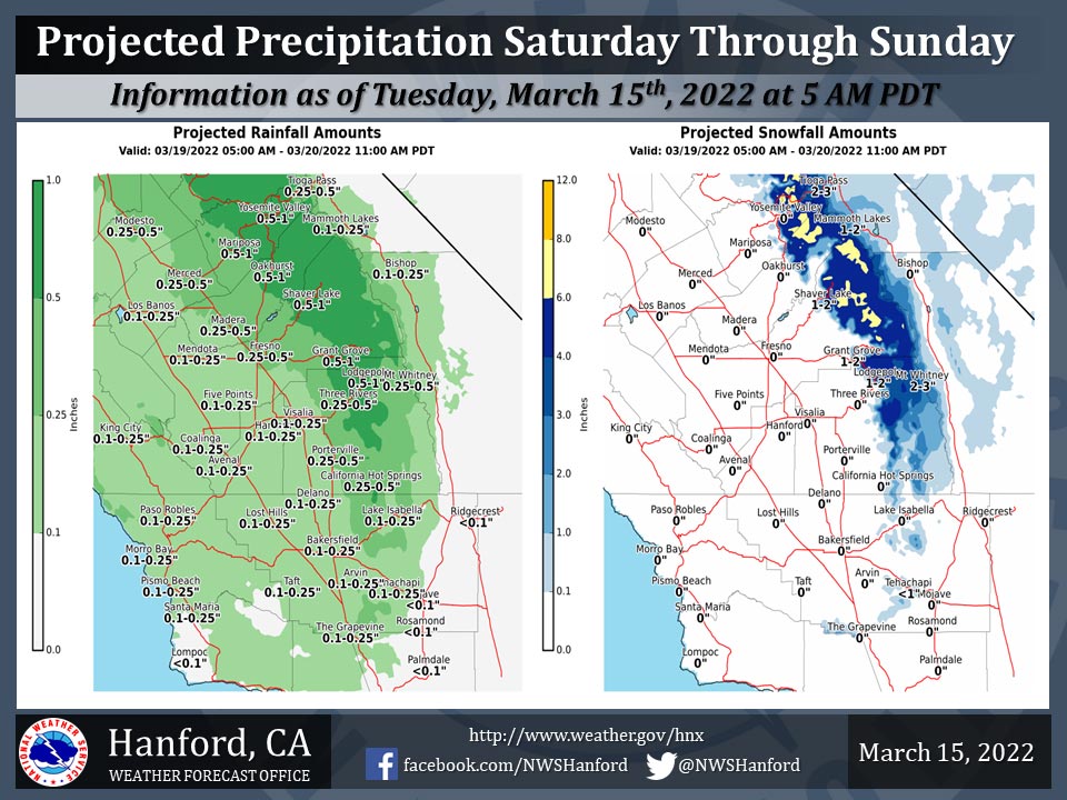
Projected Precipitation for Mariposa 0.50"- 1.00"
Projected Precipitation for Oakhurst 0.50"- 1.00"
Projected Precipitation for Yosemite Valley 0.50"- 1.00"
March 15, 2022 - The National Weather Service Hanford Office reports a storm system will impact Central California Saturday through Sunday.
The snow level will start at around 6,000 feet Saturday, before dropping to around 4,000 feet by Sunday morning.
The majority of this precipitation will fall Saturday evening and Saturday night.
Area Forecast Discussion
National Weather Service Hanford CA
336 AM PDT Tue Mar 15 2022
  .SYNOPSIS...An upper trough will bring increased clouds to our
  area today along with a chance of precipitation north of Fresno
  County. It will also bring a period of increased winds to the wind
  prone areas of Kern County. Dry weather and warmer than normal
  temperatures are expected Wednesday through Friday. A storm system
  is forecast to bring valley rain and mountain snow on Saturday
  and Saturday night.

  &&

  .DISCUSSION...IR imagery showing an upper trough to our northwest
  just beginning to push southeast into our CWFA this morning. This
  system will bring increasing clouds to our areas today along with
  increased winds most noticably along the Mojave Desert Slopes
  where a Wind Advisory remains in effect from noon PDT today until
  900 am PDT Wednesday. The deeper moisture is expected to remain
  north of Fresno County and QPF progs are only indicating one to
  two tens of in inch of liquid precipitation across Yosemite
  National Park with the snow level around 8000 feet. A few
  hundredths of an inch of precipitation are possible along the
  Sierra foothills in Mariposa and Madera Counties and in Merced
  County today. Temperatures will remain fairly mild across our
  area today with high temepratures still expected to be above
  climatological normals.

  This system is expected to move east of the area on Wednesday.
  Some upslope clouds might persist into Wednesday morning along
  the valley facing slopes of the Tehachapi Mountains and the wind
  prone areas will continue to have some strong gusts through late
  Wednesday morning. By Wednesday afternoon, skies are expected to
  clear out and winds will decrease as high pressure builds inland.
  This high will be the predominant weather system across our area
  on Thursday and Friday and keep mainly clear skies and dry
  conditions across our area along with warmer than normal
  temperatures.

  Medium range ensemble means are still showing a moist upper
  trough moving across central CA this weekend with most of the
  ensemble members in fairly good agreement. The progs are showing
  the trough will move into our area on Saturday and bring cooler
  temperatures and a period of precipitation to our area Saturday
  morning through Saturday night. QPF progs are suggesting a half
  inch to an inch of liquid precipitation over the higher Sierra
  Nevada with the snow level between 6000 and 7000 feet until
  Saturday evening when it will lower to 4000 to 5000 feet behind
  the accompanying cold front. Between 5 and 10 inches of new snow
  will be possible above 7000 feet this weekend. Between two and
  four tenths of an inch of liquid precipitation is expected over
  the Tehachapi Mountains with up to an inch of snow possible above
  4000 feet on Saturday night so adverse impacts to travel over the
  Kern County passes are possible. Between one to three tenths of
  an inch of rainfall is expected over the San Joaquin Valley and
  three to six tenths of an inch of rain are expected over the
  Sierra foothills.

  This system will move east of our area by Sunday with decreasing
  showers taking place in the morning and skies clearing out by
  afternoon. Model consensus is indicating an upper ridge
  amplifying off the western CONUS coast on Monday and pushing
  inland over CA by midweek which will result in another dry spell
  for our area and a return to warmer than normal temperatures.

  &&

  .AVIATION...Increasing areas of mountain obscuring IFR in low
  clouds and precipitation over the Sierra Nevada north of Kings
  Canyon through 18Z today when mainly IFR thru 24Z today with
  gradual improvement to VFR by 06Z Wed. Increasing areas of MVFR
  with local mountain obscuring IFR over the remainder of the Sierra
  Nevada and the Tehachapi Mountains and valley facing slopes in
  upslope clouds after 21Z today. Otherwise, VFR conditions will
  prevail over the central CA interior for the next 24 hours.

  &&

  .AIR QUALITY ISSUES...None.
Source: NWS
