


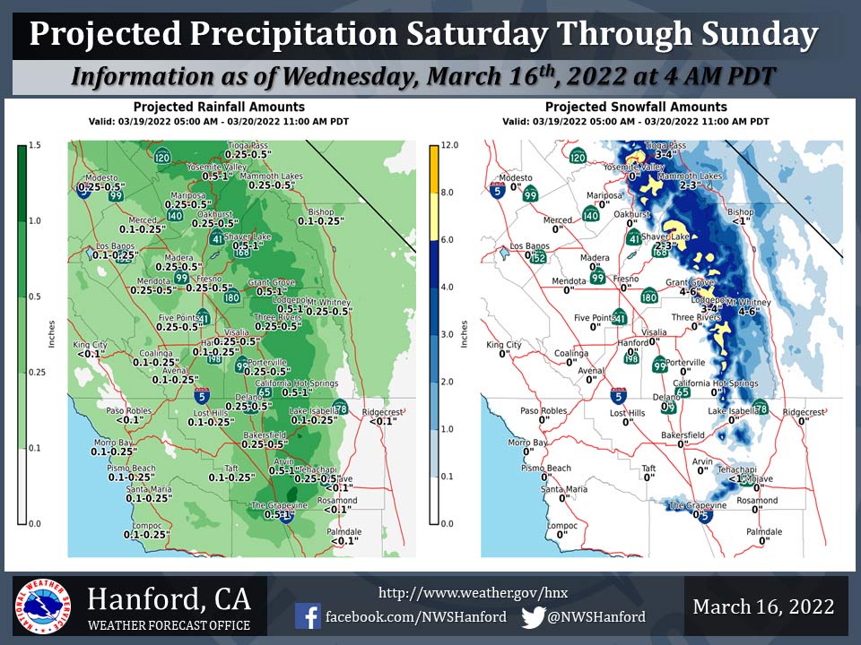
Projected Precipitation for Mariposa 0.25"- 0.50" Lowered from 0.50"- 1.00"
Projected Precipitation for Oakhurst 0.25"- 0.50" Lowered from 0.50"- 1.00"
Projected Precipitation for Yosemite Valley 0.50"- 1.00" No Change
March 16, 2022 - The National Weather Service Hanford Office reports a storm system will impact Central California Saturday through Sunday.
The snow level will start at around 6,000 feet Saturday, before dropping to around 4,000 feet by Sunday morning.
The majority of this precipitation will fall Saturday evening and Saturday night.
  Area Forecast Discussion
  National Weather Service Hanford CA
  423 AM PDT Wed Mar 16 2022


  .SYNOPSIS...
  Upper level trough will continue to bring an increase in winds
  across the area through this morning as the system exits the
  region later today. Strongest wind gusts will occur in wind favored
  locations such as through and below the mountain passes in Kern
  County. Dry weather will continue through Friday, before a storm
  system brings valley rain and mountain snow this weekend. Warm and
  dry weather will then return by the beginning of next week.

  &&

  .DISCUSSION...
  An upper level disturbance over the southern half of California
  will continue to bring increased westerly winds to the area with
  the strongest gusty conditions occurring in the wind favored
  locations such as through and below the mountain passes of Kern
  County through this morning. Gusts just over 50 mph have already
  occurred over the last several hours near Cache Creek along State
  Route 58 in the Tehachapi mountains of Kern County. A wind
  advisory remains in effect until 9AM this morning due to this wind
  threat.

  Shortwave ridging in the wake of this disturbance will bring a
  warming trend with above normal temperatures through Friday. By
  Friday high temperatures across the area will run about 5 to 9
  degrees above the normal levels which currently sit at 67 for
  Fresno and 70 degrees at Bako. However, cooling temperatures and
  wetter weather will not be far behind as a digging Pacific
  Northwest trough moves southeastward into the region early on
  Saturday.

  As this trough digs into the southwest CONUS, it will quickly
  begin to strengthen as it moves eastward into the central US on
  Sunday but not before it increases winds and the chances of
  precipitation for our area along with a return to slightly below
  normal temperatures. A trace to a quarter of an inch in rainfall
  for most parts of the San Joaquin Valley with the lesser amounts
  in the western parts of the valley. One quarter to about a half of
  an inch in rainfall could fall in the far eastern parts of the
  SJV and the lower foothills, while a half on an inch to around
  three quarters of an inch is a good bet in the higher elevations.
  Snow levels will start out around 6000 feet with the onset of
  precipitation on Saturday and then fall to around 3500 to 4000
  feet by Sunday morning when the precipitation begins to taper off.
  The Grapevine and Tehachapi city areas look to see mainly the
  liquid variety of precipitation for most of the event but by early
  Sunday morning a change over to the frozen variety could cause
  travel issues on the Tehachapi and Grapevine passes. Snow amounts
  in these locations look to be less than an inch, however we know
  that even small amounts of snowfall in these areas make for
  difficult travel situations. In the higher elevations of the
  Sierra snow will range from a trace to six inches in depth, with a
  few localized accumulations up to 8 inches possible. Winds will
  once again be highest through and below the wind favored passes
  and canyons. At this time the stronger winds will take place early
  Sunday.

  By Monday, in the wake of this strengthening low by then sitting
  over the Texas panhandle region, a very large Pacific ridge will
  begin to move into the western CONUS. Very warm high temperatures,
  about 13 to 20 degrees above normal levels, will develop over the
  region by Tuesday and Wednesday of next week. Fresno and
  Bakersfield will see high temperatures in the lower to mid 80s for
  those two days. There currently is a 96 percent chance of a high
  temperature of at least 80 degrees for Fresno next Wednesday.
  Bakersfield that chance sits at 92 percent. Early summer-like
  warmth returns.

  On a personal note, a promotion will take me back a bit closer to
  my birthplace, the little quaint village called Chicago, and will
  be stationed in the Hoosier state. So time to dust off my snow
  boots and sharpen my snow shovel once again. As this may likely be
  my last discussion here before I leave, I do want to thank all of
  the public and partners that I have gotten a chance to meet and
  talk meteorology with over the last 10 and a half years or so here
  in central California. You have all been great hosts. So I say
  farewell at least for now, who knows what the future will bring.
  Thanks for the great memories.

  &&

  .AVIATION...VFR conditions will prevail over the central CA
  interior for the next 24 hours.

  &&

  .AIR QUALITY ISSUES...
  None.
Source: NWS
