


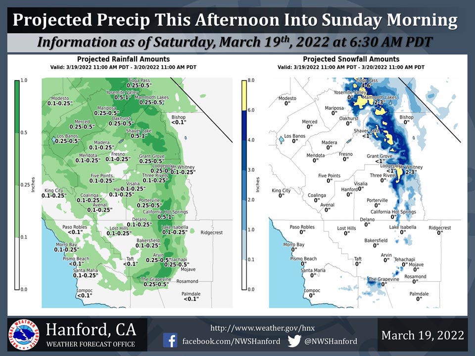
Projected Precipitation for Mariposa 0.25"- 0.50"
Projected Precipitation for Oakhurst 0.25"- 0.50"
Projected Precipitation for Yosemite Valley 0.50"- 1.00"
March 19, 2022 - The National Weather Service Hanford Office reports a storm system will impact Central California this afternoon into early Sunday morning.The snow level will start at around 7,000 feet today, before dropping to around 5,000 feet tonight.
The majority of this precipitation will fall this evening.
  Area Forecast Discussion
  National Weather Service Hanford CA
  116 AM PDT Sat Mar 19 2022

  .SYNOPSIS...
  Precipitation associated with a low pressure system will
  overspread Central California late this morning through this
  afternoon. Precipitation will persist tonight, before dissipating
  early Sunday morning. A warming trend is expected Monday and
  Tuesday. Near record warmth is likely Wednesday afternoon and
  Thursday afternoon.

  &&

  .DISCUSSION...
  An Eastern Pacific trough of low pressure will approach the west
  coast of the United States this morning, prior to making landfall
  this afternoon. Precipitation ahead of this trough of low pressure
  will overspread Central California late this morning and this
  afternoon. The trough of low pressure will move east of the Golden
  State early Sunday morning, which will bring an end to
  precipitation chances.

  The snow level will start to around 7,000 feet today, before
  falling to about 5,000 feet tonight. In the Sierra Nevada, snow
  amounts of three to six inches are anticipated above 7,000 feet
  this afternoon into early Sunday morning. Snow amounts of one to
  three inches are likely from 6,000 feet to 7,000 feet this
  afternoon into early Sunday morning. Snow amounts of an inch or
  less are expected from 5,000 feet to 6,000 feet this afternoon
  into early Sunday morning. Rain amounts will be less than one
  tenth of an inch in the Coastal Range and western portion of the
  San Joaquin Valley this afternoon into early Sunday morning. Rain
  amounts will be one tenth of an inch to one quarter of an inch in
  the central and eastern portions of the San Joaquin Valley this
  afternoon into early Sunday morning. Rain amounts will be one
  quarter of an inch to one half of an inch in the Sierra Nevada
  foothills this afternoon into early Sunday morning.

  Strong, gusty west winds are expected in the Mojave Desert Slopes
  this afternoon through Sunday morning. A Wind Advisory is in
  effect for the Mojave Desert Slopes for this time frame. Damaging
  northeast wind gusts are possible in the higher elevations of the
  Mariposa, Madera, and Fresno County portions of the Sierra
  Nevada from late Sunday morning through Sunday evening. As a
  result, a High Wind Watch is in effect.

  An anticyclone will be centered near latitude 30 North, longitude
  130 West Monday and Monday night. A ridge of high pressure will
  build northward across Northern California Tuesday. This ridge of
  high pressure will shift southward Tuesday night through Thursday.
  Zonal flow aloft is expected Friday. A warming trend is expected
  Monday and Tuesday. High temperatures Monday afternoon will be
  around five degrees warmer than Sunday afternoon. Maximum
  temperatures Tuesday afternoon will be about ten degrees warmer
  than Monday afternoon. High temperatures Wednesday afternoon and
  Thursday afternoon will be sixteen to eighteen degrees above
  normal for this time of year. Record warmth is expected in Fresno
  (86% probability), Madera (86% probability), and Merced (85%
  probability) Wednesday afternoon. Record warmth is likely in
  Hanford (73% probability) Wednesday afternoon. Record warmth is
  possible in Bakersfield (43% probability) Wednesday afternoon.
  Record warmth is expected in Merced (95% probability), Fresno (91%
  probability), and Madera (91% probability) Thursday afternoon.
  Record warmth is likely in Bakersfield (67% probability) and
  Hanford (60% probability) Thursday afternoon.

  &&

  .AVIATION...
  A low pressure system will spread precipitation southward across
  central California, beginning 18z this morning. This will result
  in intermittent MVFR conditions, along with local IFR conditions
  and mountain obscurations in the Sierra Nevada.

  &&

  .AIR QUALITY ISSUES...
  None.
Source: NWS
