


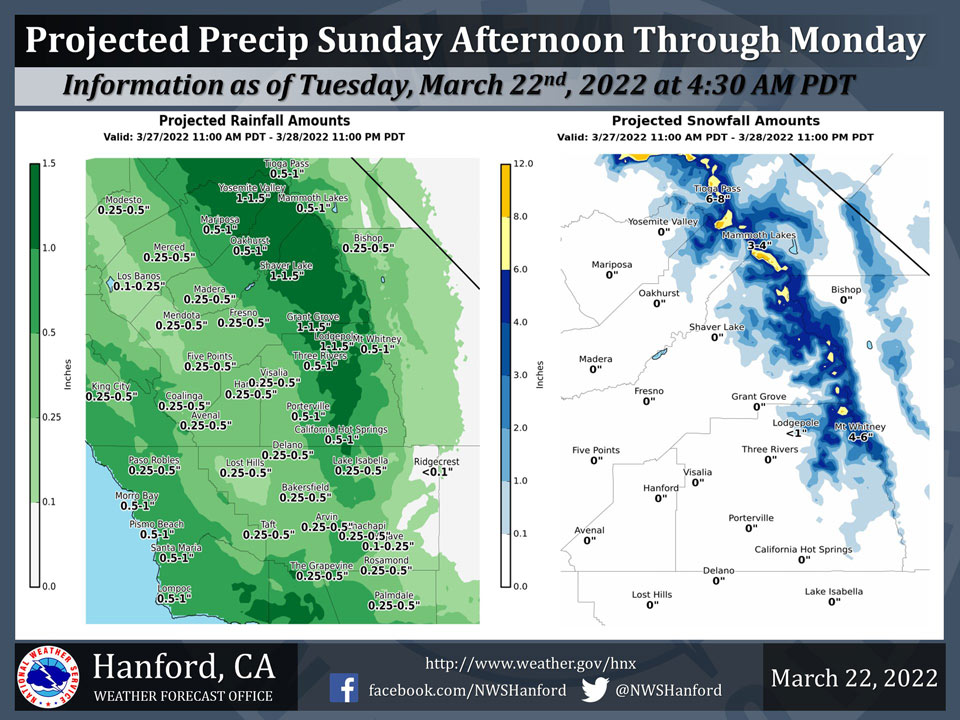
Projected Precipitation for Mariposa 0.50" - 1.00"
Projected Precipitation for Oakhurst 0.50" - 1.00"
Projected Precipitation for Yosemite Valley 1.00" - 1.50"
March 22, 2022 -The National Weather Service Hanford Office reports a storm system will approach Central California late this weekend into early next week, resulting in the possibility of precipitation.
Snow levels will start at around 8,000 feet Sunday afternoon, before falling to about 6,000 feet by Monday morning.
The best chance of precipitation is expected Sunday night and Monday morning. Forecast certainty is low at this time.
  Area Forecast Discussion
  National Weather Service Hanford CA
  338 AM PDT Tue Mar 22 2022


  .SYNOPSIS...
  A significant warming trend is forecast to take place across the
  forecast area over the next few days as a ridge of high pressure
  builds. Record heat will be possible, especially Wednesday through
  Friday for several locations in the San Joaquin Valley. Cooler
  later this weekend as a trough of low pressure could cool things
  back to normal and bring a slight chance of precip to the area.

  &&

  .DISCUSSION...
  Satellite loops show clear skies prevail throughout the central
  California interior this morning as an east Pacific ridge of high
  pressure begins to build over the west coast. High temperatures
  climbed back to near normal on Monday and the warming trend will
  ramp up today with temperatures climbing another 5 to 10 degrees
  warmer. Maximum temperatures across the San Joaquin Valley this
  afternoon are forecast to be in the lower 80s. The ridge builds
  farther inland on Wednesday and becomes more positively tilted
  with the axis extending from the central California coast to the
  northern Rockies. Temperatures will climb several more degrees on
  Wednesday putting forecast highs into the middle to upper 80s for
  the San Joaquin Valley. Little changes are expected on Thursday
  with maximum temperatures remaining around 15 to 18 degrees above
  normal for this time of the year. Confidence is high that record
  high temperatures will be reached across parts of the SJ Valley
  both on Wednesday and Thursday. Temperatures nudge down slightly
  on both Friday and Saturday as the ridge starts to shift to the
  east. Probabilities remain fairly high for some record highs on
  Friday then drop off and become less likely on Saturday but are
  not out of the question.

  Ensemble guidance continues to show a Pacific trough approaching
  the coast next weekend with potential for a return to wet weather
  by Sunday. But there are some notable differences as models show
  a splitting system leading to a slower arrival. NBM guidance has
  pushed precipitation chances back to Sunday afternoon but latest
  deterministic ECMWF is about 48 hours slower as it doesn`t bring
  it in until Tuesday afternoon. So the level of certainty is low
  for precipitation arriving by Sunday. The system is not very cold
  with snow levels expected to be above 6000 feet.

  &&

  .AVIATION...
  VFR conditions will prevail across Central California through at
  least the next 24 hours.

  &&

  .AIR QUALITY ISSUES...
  None.
Source: NWS
