


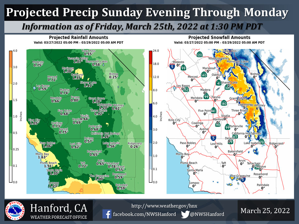
Projected Precipitation for Mariposa: 1.38"
Projected Precipitation for Oakhurst: 1.37"
Projected Precipitation for Yosemite Valley: 1.07"
March 26, 2022 -The National Weather Service Hanford Office reports a storm system will move over Central California late this weekend into early next week bringing widespread precipitation.
Snow levels are expected to be around 6,000 feet and above Sunday evening through Monday.
Area Forecast Discussion
National Weather Service
Hanford CA
218 AM PDT Sat Mar 26 2022
  .SYNOPSIS...
  Well above average temperatures will continue today, with some
  records possible in the San Joaquin Valley. Valley rain and high
  elevation snow are likely mainly Sunday evening into Monday with
  some lingering showers possible Tuesday. Otherwise, dry weather
  and mainly seasonal temperatures are expected by the middle of
  next week.

  &&

  .DISCUSSION...
  Record highs were reached at quite a few locations in the San
  Joaquin Valley once again yesterday. Bakersfield did not report a
  record high, but was four degrees shy of the record. At least one
  more day of warm weather is in store, as high temperatures will
  likely remain in the 80`s in much of the San Joaquin Valley and
  the Kern County desert. The high pressure ridging currently in
  place will weaken and shift eastward by Sunday. This will give way
  to the approaching trough that will likely provide Central
  California with some precipitation and a return to cooler weather.
  The probability that a record high will be reached in the San
  Joaquin Valley today ranges from 15 to 20 percent at Madera and
  Merced to near 35 percent in Fresno. Locations to the south, such
  as Bakersfield and Hanford, may get near their record highs, or
  within a couple of degrees.

  Sunday is expected to be a bit cooler, though still with well
  above average temperatures. Southwesterly flow ahead of the low
  pressure system will increase as the upper-level low moves closer
  to the Central CA coast on Sunday. This could bring some gusty
  winds to the typical prone areas, such as the West Side Hills and
  west side of the San Joaquin Valley, as well as the Kern County
  mountains and desert. Precipitation chances will begin towards
  the western side of our forecast area by Sunday afternoon and will
  spread over much of the region from Sunday evening into Monday.
  During Sunday night into Monday, the upper-level low will move
  onshore, so another possible concern will be increased southerly
  winds through the Grapevine. On Monday afternoon, as the upper-
  level low moves over the Central Valley, there is a slight chance
  of thunderstorms due to cold air instability. By Monday night,
  winds may ramp back up over the Kern County mountains and desert,
  as the flow turns back to westerly with the center of the upper-
  level low to the east of our forecast area. Rain and mountain snow
  will likely last until at least Monday evening, though lingering
  showers and low clouds are possible into Tuesday morning over the
  mountains. Snow levels will likely remain above 5,500 feet for the
  duration of this system. From Sunday until Monday, total
  precipitation amounts range from around 0.25 to 0.50 inch for the
  Kern County desert, 0.50 to 0.80 inch for the San Joaquin Valley
  and West Side Hills, and around 0.75 to 1.25 inches in the
  mountains and foothills. Probabilities of reaching these
  thresholds is about 70 percent. Snow accumulations are projected
  to be several inches to over a foot, mainly in the Sierra Nevada.
  The bulk of this precipitation will be during the daytime on
  Monday.

  Outside of the mountain areas and south end of the San Joaquin
  Valley, expect gradual clearing on Tuesday with near average or
  slightly cooler temperatures to prevail throughout Central
  California. After the trough moves east of the area, a gradual
  warming and drying trend will begin by Wednesday. However, we do
  not expect the strong high pressure ridging to return, and
  temperatures are projected to rise to a few degrees above average
  through the end of next week. Overall, a more typical early
  springtime pattern will prevail after early next week, at least in
  terms of temperatures.

  &&


  .AVIATION...
  VFR conditions will prevail across Central California through at
  least the next 24 hours.

  &&

  .AIR QUALITY ISSUES...
  None.
Source: NWS
