


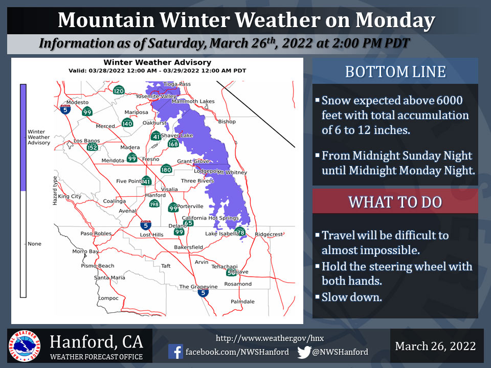
March 27, 2022 -The National Weather Service Hanford Office reports a Winter Weather Advisory will go into effect for the period from Midnight on Sunday Night and go through Midnight on Monday Night.
Snow expected above 6000 feet. Total snow accumulations of 6 to 12 inches. Isolated amounts up to 18 inches possible over the highest elevations.
Winds gusting as high as 45 mph.
Travel could be very difficult to impossible.
The latest road conditions for the state you are calling from can be obtained by calling 5 1 1. (Caltrans at 1-800-427-7623).
  Area Forecast Discussion
  National Weather Service Hanford CA
  210 AM PDT Sun Mar 27 2022

  .SYNOPSIS...
  High pressure will give way to an approaching low pressure system
  tonight through Monday night. Rain and mountain snow will begin
  tonight and persist into Tuesday morning before the storm system
  moves east of the area. High pressure will rebuild beginning later
  Tuesday with a warming and drying trend through the week.

  &&

  .DISCUSSION...
  Water vapor imagery shows the strong ridge of high pressure over
  California now beginning to shift the the east as an incoming
  Pacific low pressure system drops southeast along 38N/137W. This
  incoming system will bring a big change to cooler and wet weather
  for the Central California Interior beginning tonight and lasting
  through Monday night.

  Latest deterministic runs of the GFS and ECMWF models bring the
  onset of precipitation into Merced County between 11 PM this
  evening and 5 AM Monday morning with the most likely time period
  of concentrated rain and mountain snow during the morning hours on
  Monday. During the afternoon on Monday the center of low pressure
  is projected to move into the Central Coast and across Kern County
  in the late afternoon and evening hours. The cold pool aloft will
  rapidly increase instability with the threat of thunderstorms
  through the afternoon and early evening hours spreading from
  northwest to southeast.

  As for expected precipitation amounts, ensemble modeling continues
  to forecast a consistent 0.50" of rain give or take a little and
  Fresno and most SJV locations. Of course, heavier amounts will be
  observed at locations that get thunderstorms. Small hail is likely
  with some of the storms along with brief heavy rain.

  In the Sierra, the Winter Weather Advisory looks to be on track as
  latest ensemble modeling cranks out up to 16" of snow over the
  higher terrain in a few spots and a much more widespread 6-12"
  at elevation above 6000 feet. This storm system will most likely
  not drop any widespread snow at pass level in Kern County,
  however a heavier thunderstorm may bring enough cold air to the
  surface to produce a quick shower of snow pellets (graupel) in a
  few places on Monday afternoon and evening.

  For later today and tonight winds will be on the increase as
  pressure gradients increase and Wind Advisories are posted for the
  West Side Mountains and the Mojave Desert Slopes. Expect gusty
  winds to continue on Monday as the front passes through the
  region.

  All of the precipitation will come to an end early Tuesday as the
  low moves to the east and high pressure builds over the West.
  Forecast models keep the ridge of high pressure in place for much
  of the upcoming week however the ridge will not be nearly as
  strong as the previous event and although temperatures will
  warm up in the wake of Monday`s cold low, no records will be
  approached.

  Using probabilistic forecasting methodology from the NBM (National
  Blend of Models) gives both Fresno and Bakersfield a 50-55% chance
  of 0.75" of rain on Monday. This has actually has trended up over
  the past couple of days and any "bonus" rainfall is certainly
  needed in this continued drier than normal winter.

  &&

  .AVIATION...
  VFR conditions will prevail across Central California through 06Z
  then incoming precipitation will bring areas of MVFR ceilings and
  mountain obscurations there after.

  &&

  .AIR QUALITY ISSUES...
  None.
Source: NWS
