


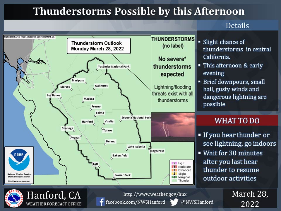
Includes Mariposa, Oakhurst, and Yosemite National Park
March 28, 2022 - The National Weather Service Hanford Office reports a few thunderstorms are possible in much of central California this afternoon into the early evening.
Small hail and wind gusts near 40 mph may accompany thunderstorms.
In addition to dangerous cloud to ground lightning strikes, any thunderstorm can produce intense rainfall rates, leading to localized flooding.
  Area Forecast Discussion
  National Weather Service Hanford CA
  213 AM PDT Mon Mar 28 2022


  .SYNOPSIS...
  An approaching low pressure system will continue to move further
  inland and bring rain and mountain snow along with a slight
  chance for thunderstorms today. Precipitation will continue until
  Tuesday morning before the storm system moves east of the area.
  High pressure will rebuild beginning later Tuesday with a warming
  and drying trend through the week.

  &&

  .DISCUSSION...
  The storm will continue to progress inland during tonight and into
  the daylight hours today. Based on latest radar imagery, the
  outer band of showers are currently over western portions of the
  San Joaquin Valley, including over Merced and western Fresno
  Counties. This band, and the main band currently along the coast,
  will continue to progress eastward tonight and into the daylight
  hours later this morning. Precipitation can be expected
  throughout interior Central California for much of today, as well
  as higher elevation snow. There also remains a slight chance of
  thunderstorms with small hail possible for mainly this afternoon,
  and the possibility exists at any location in our forecast area.
  There will be sufficient ingredients for potential development of
  thunderstorms, including cold air aloft, moisture, and dynamics.
  In addition, cooler than normal temperatures are on tap for today,
  as highs struggle to top the mid-60`s at the warmest spots. Storm
  activity will likely taper off during this evening, though
  chances remain until at least Tuesday morning, including over the
  mountain areas.

  The storm generally remains on track in terms of precipitation
  amounts through Tuesday morning, though the latest blended
  guidance has shown some downward trend in probabilities for the
  forecast amounts. Locations in the Sierra Nevada will likely
  observe 0.75 to 1.25 inches of rain at elevations mainly below
  5,500 feet and several inches to over a foot of snow above this
  level, with some localized amounts around 15 to 18 inches
  possible. For the San Joaquin Valley, forecast amounts are around
  0.50 to 0.75 inch, though the latest probability for 0.50 inch of
  precipitation is at around 30 to 50 percent depending on
  location while the best chances for this amount are over Kern
  County. There is around a 30 to 40 percent chance of 0.25 inch of
  rainfall for the Kern County desert. Thus, it is more likely
  these areas could observe lower amounts than forecast. However,
  if a location observes a thunderstorm, it is conceivable that
  precipitation amounts could be a bit heavier. Most of the shower
  activity will likely taper off by this evening.

  Tuesday is expected to be warmer with near seasonal temperatures,
  as the storm moves into the Desert Southwest. However, some showers
  may continue over the mountains with gradual clearing through the
  afternoon. After this storm exits, it is likely we won`t observe
  additional precipitation for the remainder of March.

  A return to seasonal temperatures and mostly clear skies is in
  store for Wednesday and Thursday. We do not expect a major warming
  trend through the remainder of the week, although daytime high
  temperatures could rise back to around 10 degrees above seasonal
  averages by Saturday. There is the potential for another low
  pressure system to brush the area late on Sunday or next Monday
  with another cooling trend and possibly some showers over the
  mountains. However, any amounts could be very light. Overall, a
  typical springtime pattern will prevail.

  &&


  .AVIATION...
  Incoming precipitation will bring areas of MVFR ceilings and
  IFR conditions in the Sierra Nevada and Kern County mountains due
  to mountain obscurations through the period. Otherwise, VFR
  conditions can be expected for the next 24 hours.

  &&

  .AIR QUALITY ISSUES...
  None.
Source: NWS
